Geo-information data analysis on rivers and catchments
SamSamWater collected and analysed all (freely) available geo-information for a large Water Project in the Kajiado District of Kenya.
Topographical, geological and soil maps, as well as GIS information on surface level elevation, satellite imagery and topographical features was aquired. The data has been combined in several maps used for further hydrological assessment, on for example rivers and catchments.


Project details
| Project location: | Kajiado district, Kenya |
| (find climate data for this location) | |
| Project manager: | Sander de Haas |
| External website: | http://www.amref.org |
| Period: | 2009 - 2010 |
Data for this project
Detail of the satellite imagery map near Bisil (Ilbisil)
Scale 1:25,000
| Size: | 12.84 MB |
| Date: | 2011-04-06 |
| Author: | Sander de Haas |
| Contact: | sanderdehaas@samsamwater.com |
| Reference: |

Water supply and borehole map of Bisil (Ilbisil)
Scale 1:20,000
| Size: | 7.05 MB |
| Date: | 2011-04-06 |
| Author: | Sander de Haas |
| Contact: | sanderdehaas@samsamwater.com |
| Reference: |

Detail of the elevation map near Bisil (Ilbisil)
Scale 1:25,000
| Size: | 364.03 KB |
| Date: | 2011-04-06 |
| Author: | Sander de Haas |
| Contact: | sanderdehaas@samsamwater.com |
| Reference: |

Detail of the soil map near Bisil (Ilbisil)
Scale 1:25,000
| Size: | 1.48 MB |
| Date: | 2011-04-06 |
| Author: | Sander de Haas |
| Contact: | sanderdehaas@samsamwater.com |
| Reference: |

Satellite imagery map of the Kajiado project area
Scale 1:200,000
| Size: | 17.97 MB |
| Date: | 2009-02-25 |
| Author: | Sander de Haas |
| Contact: | sanderdehaas@samsamwater.com |
| Reference: |

Detail of the satellite imagery map of the Kajiado project area
Scale 1:25,000
| Size: | 6.38 MB |
| Date: | 2009-02-25 |
| Author: | Sander de Haas |
| Contact: | sanderdehaas@samsamwater.com |
| Reference: |

The elevation map of the Kajiado project area
Scale 1:200,000
| Size: | 1.63 MB |
| Date: | 2009-02-25 |
| Author: | Sander de Haas |
| Contact: | sanderdehaas@samsamwater.com |
| Reference: |

Detail of the elevation map of the Kajiado project area
Scale 1:25,000
| Size: | 514.64 KB |
| Date: | 2009-02-25 |
| Author: | Sander de Haas |
| Contact: | sanderdehaas@samsamwater.com |
| Reference: |

Soil map of the Kajiado project area
Scale 1:200,000
| Size: | 15.92 MB |
| Date: | 2009-02-25 |
| Author: | Sander de Haas |
| Contact: | sanderdehaas@samsamwater.com |
| Reference: |

Detail of the soil map of the Kajiado project area
Scale 1:25,000
| Size: | 1.77 MB |
| Date: | 2009-02-25 |
| Author: | Sander de Haas |
| Contact: | sanderdehaas@samsamwater.com |
| Reference: |

Topographic overview map of the Kajiado project area
Scale 1:200,000
| Size: | 6.36 MB |
| Date: | 2009-02-25 |
| Author: | Sander de Haas |
| Contact: | sanderdehaas@samsamwater.com |
| Reference: |

Topographic overview map
Scale 1:1,000,000
| Size: | 5.82 MB |
| Date: | 1967-01-01 |
| Author: | Survey of Kenya |
| Contact: | sanderdehaas@samsamwater.com |
| Reference: |

Preliminary soil map of Kajiado District
Scale 1:250,000
| Size: | 10.60 MB |
| Date: | 1977-04-01 |
| Author: | UNDP FAO Wildlife Management Project & Kenya Soil Survey |
| Contact: | sanderdehaas@samsamwater.com |
| Reference: |

Geological map of the Kajiado area
Scale 1:125,000
| Size: | 2.92 MB |
| Date: | 1964-01-01 |
| Author: | Minitry of Natural Resources, Kenya |
| Contact: | sanderdehaas@samsamwater.com |
| Reference: |

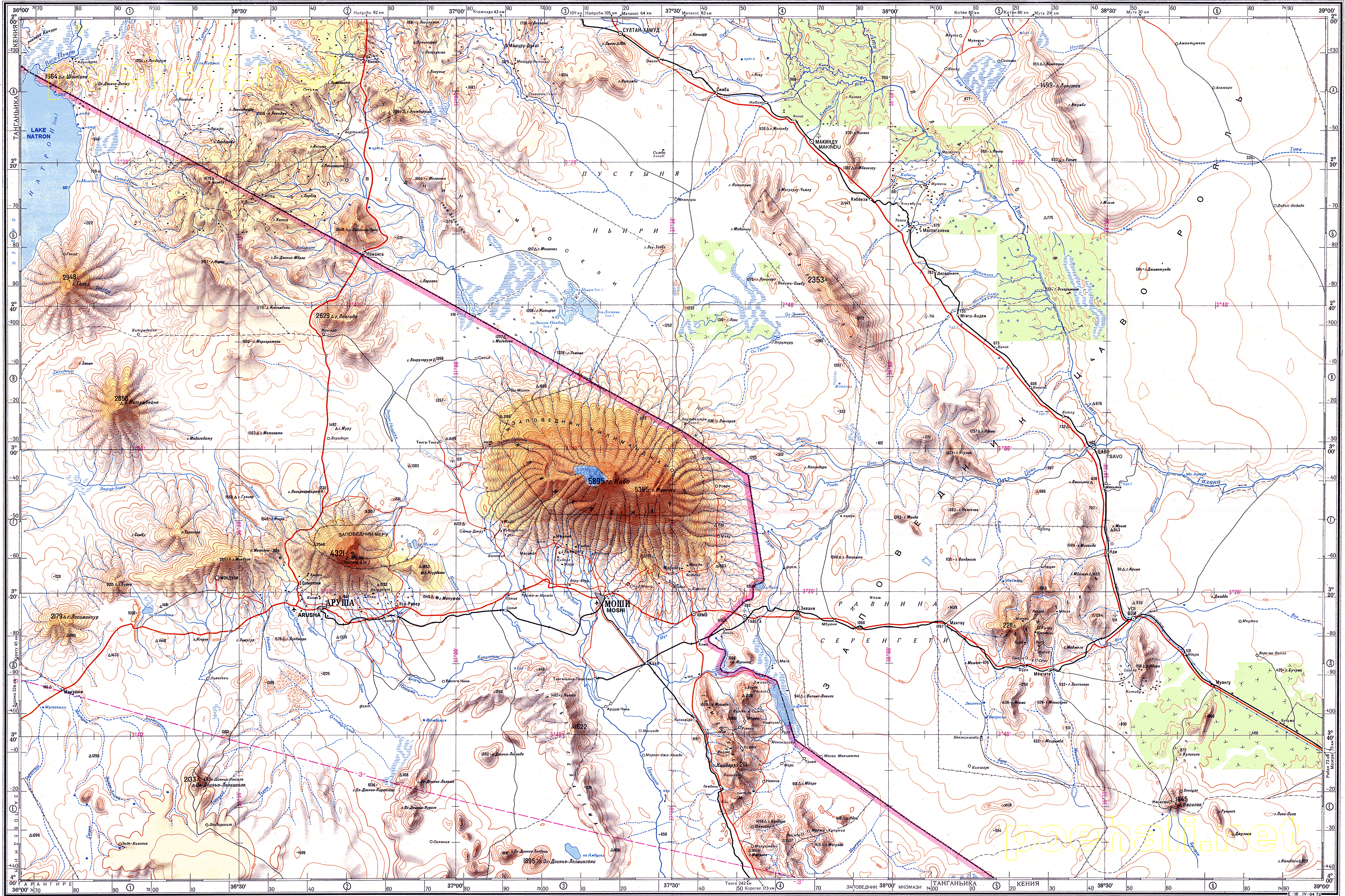
Topographic map of the Kajiado area
Scale 1:500,000
| Size: | 2.50 MB |
| Date: | 0000-00-00 |
| Author: | Soviet |
| Contact: | sanderdehaas@samsamwater.com |
| Reference: |