
Filter op categorie
Of zoek
Zoekformulier wordt geladen...
Toelichting
SamSamWater maakt informatie over water en sanitatie beschikbaar en toegankelijk voor iedereen.
Hierom hebben we een database opgezet, die via deze pagina geraadpleegd kan worden. De database bevat allerlei informatie, bijvoorbeeld 'best practices' (bewezen technieken), kaarten, geo-informatie en achtergrondinformatie. De informatie is afkomstig van verschillende bronnen, waaronder onderzoeksinstituten, bedrijven, organisaties en overheidsinstellingen.
Als u informatie heeft die wij in onze database kunnen opnemen, of als u opmerkingen of vragen heeft, dan horen wij dit graag!
N.B. De documenten en beschrijvingen op deze pagina zijn vooralsnog alleen beschikbaar in het Engels. Als u behoefte heeft aan een Nederlandse vertaling dan kunt u rechtsboven op deze pagina op "Overige talen" klikken. Vervolgens kunt u "Nederlands" selecteren in het pull down menu, waarna deze pagina via een automatische vertaling naar het Nederlands vertaald zal worden.
14 items gevonden in de categorieën:
Geologie en bodem
Verwijder zoekfilter.
Bureau of Reclamation, U.S. Department of the Interior (1998)
ICS, IUGS, ICS (2008)
Geologie en bodem
Verwijder zoekfilter.
ArcGIS Services Directory
Directory of the ESRI basemaps, with links to open them in ESRI software (e.g. ArcMAP) or in Google Earth (not available for every map).
Engineering Geology Field Manual
Bureau of Reclamation, U.S. Department of the Interior (1998)
The manual etablishes common guidelines, procedures and concepts for the collection, evaluation and presentation of geologic information. How to use geological information to obtain site charateristics and risk evaluation. (source)
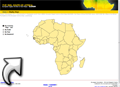
European Digital Archive of Soil Maps of Africa
An impressive collection of soil maps from all over Africa (over 2000!). All maps can be viewed and downloaded in high resolution. Contains also some topographical maps. Searchable by country, scale, year, of keyword.
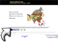
European Digital Archive of Soil Maps of Asia
A large collection of soil maps of Asia. Searchable by country, scale, year, of keyword.
European Digital Archive of Soil Maps of the World
Soil maps of the world, a large collection of scanned soil maps from all over the world.
IGRAC Global Groundwater Information System
Global Groundwater Information System, with maps on groundwater quality, quantity, development, artificial recharge and more. But it only shows averages per country. Only works in Internet Explorer.
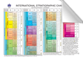
International Stratigraphic Chart
ICS, IUGS, ICS (2008)
The classic 'geological time scale' is a hierarchical ordinal system, in which the eras are ranked: 'stages' nest within 'series'within 'systems' within 'eras' within 'eons'. The ICS publishes a representation of the geologic timescale as a coloured stratigraphic chart, showing the order and names of the elements of the time scale, and the dates of the boundaries as fixed through GSSP where available. (source)
ISRIC - World Soil Information Database
ISRIC - World Soil Information Database, you can search the database using the menu on the left. Some of the reports and maps can be viewed online and downloaded.
OneGeology Portal
A beautiful web-viewer with a lot of digital geological maps all over the World. Some maps have a very large scale (continent), others are more detailed (country). You can export the maps from their portal as KML files to view in Google Earth. Background information and a 'Getting started' guide can be found here: http://www.onegeology.org/portal/home.html.
Search Alterra maps
A collection of maps from the Alterra Institute (Wageningen University). Use the searchform on the right, the 'Region thesaurus' on the left doesn't work properly.
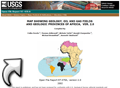
USGS geology, oil and gas map of Africa
Maps showing geology, oil and gas fields and geologic provinces of Africa.

