
WRAP Regional Water Resources Studies, Kenya (1981–1990)
The Water Resources Assessment and Planning (WRAP) project was a joint effort between Kenya’s Ministry of Water Development (now the Ministry of Water, Sanitation and Irrigation) and the TNO-DGV Institute of Applied Geoscience in the Netherlands (now GDN, the Geological Survey of the Netherlands, part of TNO). The project ran from 1981 to 1991 and was funded by the Dutch Directorate-General for International Cooperation (DGIS).
Water Resources Assessment (WRA) studies were carried out in nine Kenyan districts (now counties). The WRA reports are still a key data source for water professionals working in Kenya. They contain a wealth of original data on the quantity and quality of groundwater and surface water, compiled, checked and mapped in a single set of documents.
The surface water fieldwork included rehabilitating rain gauges, installing additional evaporation pans, stream gauging, a water permit survey, and water sampling for chemical analysis. The groundwater fieldwork included geological analysis (remote sensing and ground surveys), geophysical surveys, water level monitoring, and water sampling.
For some districts, the project also produced District Water Development Plans (DWDP). These plans are interesting, but less relevant today than the WRA reports.
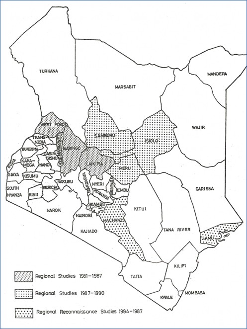
Areas covered
WRAP-1 and WRAP-2 (1981–1987): Water Resources Assessment studies
WRAP-4 (1991 onwards)
After 1991, the project continued as WRAP-4, carried out by DHV (now Haskoning). The phase IV proposal (Water Resources Assessment and Planning Phase IV, project proposal, Nairobi, April 1990) planned further WRA and DWDP studies for Marsabit, Wajir, Garissa, Tana River and Kajiado. So far, we have not found any reports from this phase.
About these copies
Copies of the WRAP reports have become hard to find, so we have made them available online.
Some of the reports come from the archives of the GDN-TNO Geological Survey of the Netherlands. We are very grateful to TNO for preserving these valuable reports for so many years and for making them available.
Complete sets of reports for Kerio Valley, Laikipia, Baringo and West Pokot came from my former colleague Slávek Vasak. Sadly, Slávek passed away in May 2026. He was a wonderful person and one of the best Dutch geologists, and he had the foresight to keep these reports in his home library. PWN drinking water company kindly digitized them. Many thanks to PWN.
Reports and maps
Click a link to open a report (PDF) or scanned map (JPG). Some reports are over 100 MB. Use the Google Earth buttons for georeferenced maps (.kmz).
Kiambu
Back to areasNdeiya and Karai locations
- PDFWRA study for the Ndeiya and Karai locations, annex 6.1, Integrated Water Supply and distribution system (DHV Consultants) October 1982 2.1 MB
- MissingWRA study for the Ndeiya and Karai locations. Main Report. Min of Water Development Nairobi 1983Not yet available
- PaperHeederik, J.P. (1984) Water resources assessment study in Kiambu District, Kenya. Challenges in African Hydrology and water Resources, Proceedings of the Harare Symposium, July 1984, IAHS Publ. no. 144. 809 KB
Kerio Valley
Back to areasElgeyo Marakwet and Baringo districts
- PDFWRA Study Kerio Valley. (TNO IS-84-014), 1984 124 MB
- MapGeology 9.4 MB
- MissingGeophysicsNot yet available
- MapHydrometric network 16 MB
- MapIsohyetal map, longterm average annual rainfall 17 MB
- MapHydrogeological map (northern sheet) 13 MBGoogle Earth 13 MB
- MapHydrogeological map (southern sheet) 17 MBGoogle Earth 17 MB
- MapExisting water supplies 15 MB
- MapWater availability 24 MB
West Pokot
Back to areas- PDFWRA Study West Pokot District. (TNO IS-84-013), 1984 117 MB
- MapGeology 5.8 MBGoogle Earth 5.8 MB
- MapHydrology 19 MB
- MapIsohyetal map, longterm average annual rainfall 21 MB
- MapHydrogeological map 22 MB
- MapWater availability 4.1 MBGoogle Earth 20 MB
- PDFShort note on prospects for water development 7.2 MB
Laikipia
Back to areas- PDFWRA Study in Laikipia District. (TNO IS-87-003), 1987 71 MB
- PDFExecutive summary 16 MB
- PDFAppendices 103 MB
- MapGeology 21 MB
- MapGeological work (locations) 8.3 MB
- MapPiezometric 19 MB
- MapHydrogeology 29 MBGoogle Earth 29 MB
- MapExisting water supplies 17 MB
- MapGroundwater availability 18 MBGoogle Earth 18 MB
- MapMean annual rainfall 17 MB
Baringo
Back to areas- MissingWRA Study in Baringo District. Main Report; Nairobi, 1987.Not yet available
- PDFWRA study in Baringo district. Executive summary (TNO IS-87-04) 18 MB
- PDFWRA study in Baringo district appendices may 1987 75 MB
- MapWater supplies 1.6 MB
- MapSurface water availability 2.6 MB
- MapGroundwater availability 2.6 MBGoogle Earth 2.6 MB
Samburu
Back to areasWater Resources Assessment study
- PDFWRA Study in Samburu District. (TNO IS-91-002), 1991 63 MB
- PDFWRA Study in Samburu District. Appendices 136 MB
- MapGeology 24 MB
- MapHydrometeorological Network 4.8 MB
- MapMedian Annual Rainfall 6.2 MB
- MapMedian Rainfall - Long Rains 5.5 MB
- MapMedian Rainfall - Short Rains 5.2 MB
- MapHydrogeology 35 MBGoogle Earth 35 MB
- MapGroundwater availability 4.9 MBGoogle Earth 4.9 MB
District Water Development study
- PDFSamburu District Water Development study 1991, executive summary 28 MB
- PDFPart 1 Water demand and Water resources 221 MB
- MapSchools, health facilities 6.0 MB
- MapWater demand 6.2 MB
- MapProposed supply development 6.2 MB
- PDFPart 2 Existing supply, technology options and costs 92 MB
- MapWater supply coverage 5.8 MB
- PDFPart 3 Guidelines and recommendations for investment packages 127 MB
- MapProposed water development. Investment package 1B 3.6 MB
- MapProposed water development. Investment package 2B 3.7 MB
- MapProposed water development. Investment package 3B 3.6 MB
Isiolo
Back to areasWater Resources Assessment study
- PDFWRA Study in Isiolo District. (TNO IS-91-004), 1991 118 MB
- MapGeology (west) 2.4 MB
- MapGeology (east) 10 MBGoogle Earth 12 MB
- MapHydrogeology (west) 2.3 MBGoogle Earth 2.3 MB
- MapHydrogeology (east) 4.5 MBGoogle Earth 4.5 MB
- MapGroundwater quality - Merti Area 3.1 MB
District Water Development study
Meru
Back to areasWater Resources Assessment study
- PDFWRA Study in Meru District. (TNO-IS-91-008-A-4) 1991. 60 MB
- PDFWRA Study in Meru District. Appendices 160 MB
- MapGeology 9.3 MBGoogle Earth 9.3 MB
- MapDepth to Basement 7.7 MBGoogle Earth 7.7 MB
- MapHydrogeology 19 MB
District Water Development study
- PDFWater Development study in Meru District 1991. Executive summary 45 MB
- PDFPart 1 Water demand and Water resources 263 MB
- PDFPart 2 Existing supply, technology options and costs 115 MB
- MapExisting water supplies 5.6 MBGoogle Earth 5.6 MB
- PDFPart 3 Guidelines and recommendations for investment packages 94 MB
- MapDomestic and livestock development 9.5 MB
- MapPotential area for irrigation 8.2 MB
Machakos
Back to areasReconnaissance study
- MissingWater Resources Reconnaissance Study in Machakos District. TNO IS-86-002Not yet available
Lamu
Back to areasReconnaissance study
South Nyanza
Back to areasGeophysical survey
Topographic maps of Kenya can be found here.
Geological maps of Kenya can be found here.
