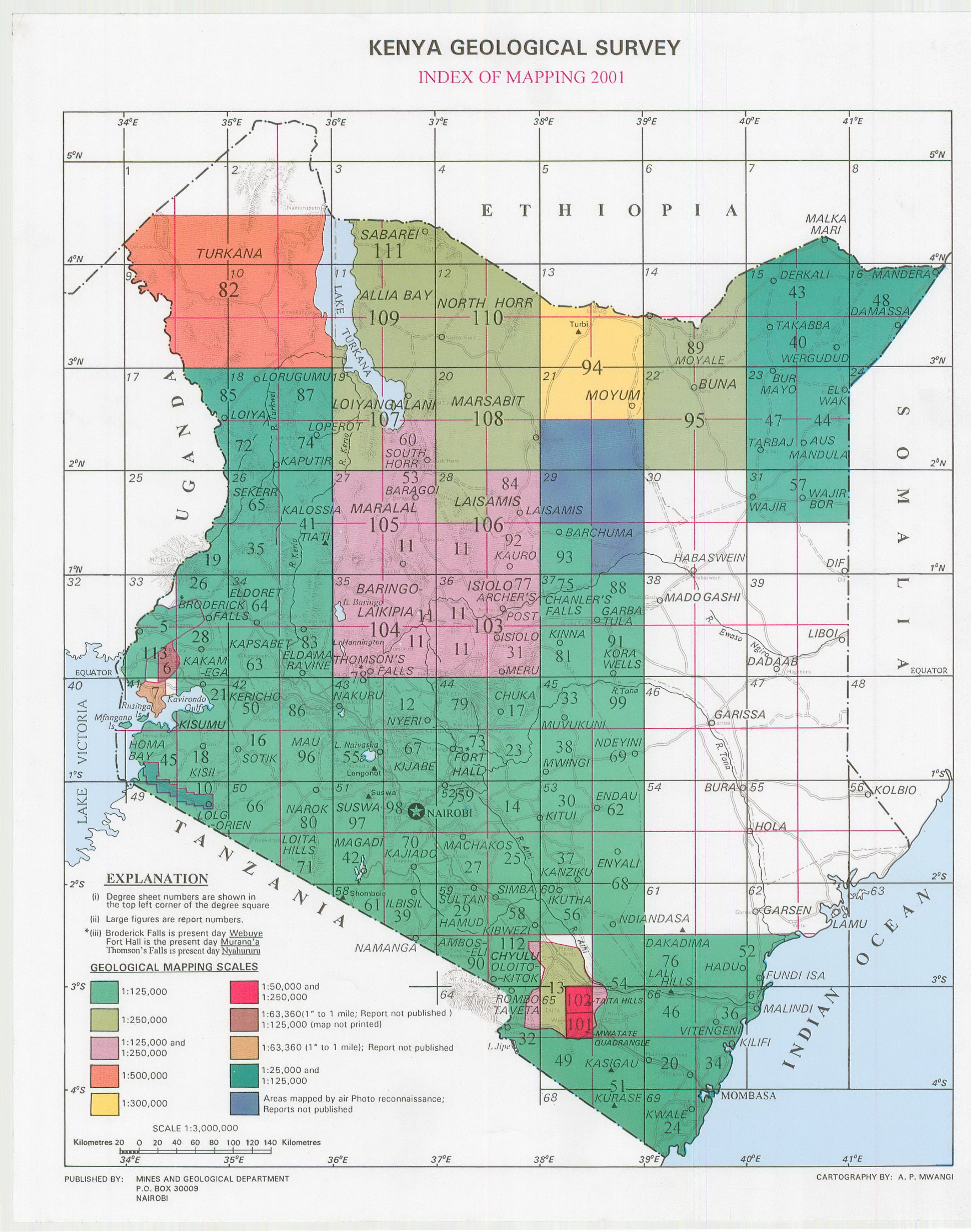
Geological maps of Kenya
Geological information is often essential for many water and sanitation projects. On this page we've published the geological maps of Kenya so that others can make use of this information in their projects or research.
An index map with the sheet numbers can be viewed to the right, or in high resolution here.
If you own the rights to any of these maps and don't want them to be published here, please contact us and we will remove them from this website.
Topographic maps of Kenya can be found here.
If you have other maps (e.g. topographical, geological, hydrological) which you would like to make available to others, please contact us so we can help you to publish them.
Geological Survey Notes on the Geological Succession, Tectonics and Economic of the Western half of Kenya colony
Year of publication: 1933
Filesize: 0,4 MB
Filesize: 0,4 MB
Geological Survey of Kenya Preliminary Report on the Geology of the No 1 Area ,North and Central Kavirondo
Year of publication: 1936
Filesize: 0,8 MB
Filesize: 0,8 MB
Geological map of Allia Bay (Degree square 11)
Scale: 1:250000,
Sheet number/quarter: Degree square 11
Year of publication: 1988
Filesize: 7,3 MB
Sheet number/quarter: Degree square 11
Year of publication: 1988
Filesize: 7,3 MB
Map coordinates
Top left: 4° 00' N, 36° 00' E
Top right: 4° 00' N, 37° 00' E
Bottom left: 3° 00' N, 36° 00' E
Bottom right: 3° 00' N, 37° 00' E
Top left: 4° 00' N, 36° 00' E
Top right: 4° 00' N, 37° 00' E
Bottom left: 3° 00' N, 36° 00' E
Bottom right: 3° 00' N, 37° 00' E

Geological map of the Amboseli area (59 SW)
Scale: 1:125000,
Sheet number/quarter: 59 SW
Year of publication: 1967
Filesize: 5 MB
Sheet number/quarter: 59 SW
Year of publication: 1967
Filesize: 5 MB
Map coordinates
Top left: 2° 30' S, 37° 00' E
Top right: 2° 30' S, 37° 30' E
Bottom left: N/A
Bottom right: N/A
Top left: 2° 30' S, 37° 00' E
Top right: 2° 30' S, 37° 30' E
Bottom left: N/A
Bottom right: N/A

Geological map of the Amboseli area (59 SW)
Scale: 1:125000,
Sheet number/quarter: 59 SW
Year of publication: 1967
Filesize: 35,2 MB
Sheet number/quarter: 59 SW
Year of publication: 1967
Filesize: 35,2 MB
Map coordinates
Top left: 2° 30' S, 37° 00' E
Top right: 2° 30' S, 37° 30' E
Bottom left: N/A
Bottom right: N/A
Top left: 2° 30' S, 37° 00' E
Top right: 2° 30' S, 37° 30' E
Bottom left: N/A
Bottom right: N/A

Geological map of Angata Salei (39)
Scale: 1:125000,
Sheet number/quarter: 39
Year of publication: 1961
Filesize: 8 MB
Sheet number/quarter: 39
Year of publication: 1961
Filesize: 8 MB
Map coordinates
Top left: 2° 30' S, 35° 30' E
Top right: 2° 30' S, 35° 30' E
Bottom left: 3° 00' S, 36° 00' E
Bottom right: 3° 00' S, 35° 30' E
Top left: 2° 30' S, 35° 30' E
Top right: 2° 30' S, 35° 30' E
Bottom left: 3° 00' S, 36° 00' E
Bottom right: 3° 00' S, 35° 30' E

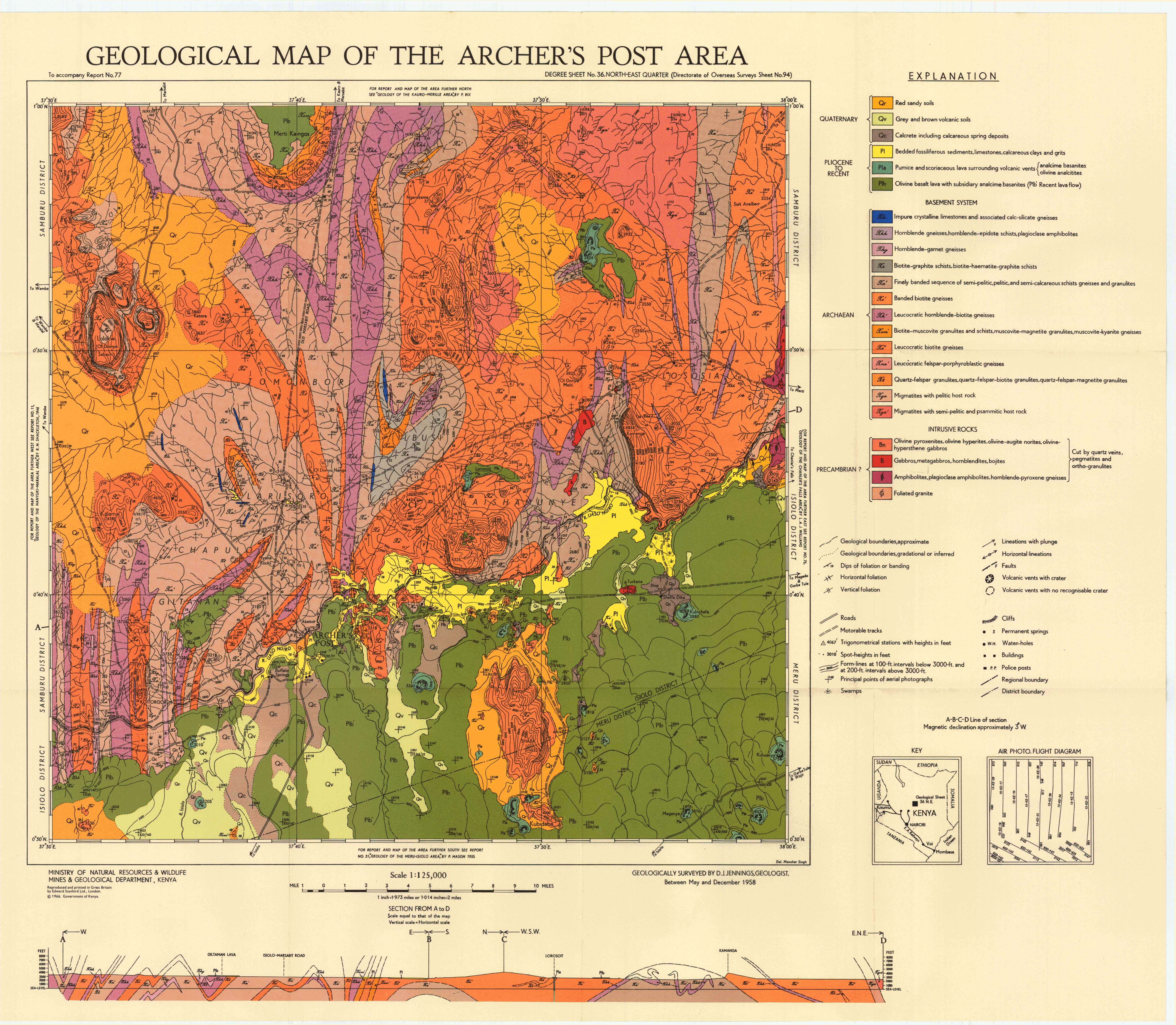
Geological map of the Archer's Post area (36 NE)
Scale: 1:125000,
Sheet number/quarter: 36 NE
Year of publication: 1966
Filesize: 6,9 MB
Sheet number/quarter: 36 NE
Year of publication: 1966
Filesize: 6,9 MB
Map coordinates
Top left: 1° 00' N, 37° 30' E
Top right: 1° 00' N, 38° 00' E
Bottom left: 0° 30' N, 38° 00' E
Bottom right: 0° 30' N, 37° 30' E
Top left: 1° 00' N, 37° 30' E
Top right: 1° 00' N, 38° 00' E
Bottom left: 0° 30' N, 38° 00' E
Bottom right: 0° 30' N, 37° 30' E
Geological map of the Aus Mandula area (23 SE)
Scale: 1:125000,
Sheet number/quarter: 23 SE
Year of publication: 1955
Filesize: 6,5 MB
Sheet number/quarter: 23 SE
Year of publication: 1955
Filesize: 6,5 MB
Map coordinates
Top left: 2° 30' N, 40° 30' E
Top right: 2° 30' N, 41° 00' E
Bottom left: 2° 00' N, 41° 00' E
Bottom right: 2° 00' N, 40° 30' E
Top left: 2° 30' N, 40° 30' E
Top right: 2° 30' N, 41° 00' E
Bottom left: 2° 00' N, 41° 00' E
Bottom right: 2° 00' N, 40° 30' E

Geological map of the Baragoi area (27 NE)
Scale: 1:125000,
Sheet number/quarter: 27 NE
Year of publication: 1955
Filesize: 8,6 MB
Sheet number/quarter: 27 NE
Year of publication: 1955
Filesize: 8,6 MB
Map coordinates
Top left: 2° 00' N, 36° 30' E
Top right: 2° 00' N, 37° 00' E
Bottom left: 1° 30' N, 37° 00' E
Bottom right: 1° 30' N, 36° 30' E
Top left: 2° 00' N, 36° 30' E
Top right: 2° 00' N, 37° 00' E
Bottom left: 1° 30' N, 37° 00' E
Bottom right: 1° 30' N, 36° 30' E

Geological map of the Baragoi area (27 NE)
Scale: 1:125000,
Sheet number/quarter: 27 NE
Year of publication: 1955
Filesize: 3,3 MB
Sheet number/quarter: 27 NE
Year of publication: 1955
Filesize: 3,3 MB
Map coordinates
Top left: 2° 00' N, 36° 30' E
Top right: 2° 00' N, 37° 00' E
Bottom left: 1° 30' N, 36° 30' E
Bottom right: 1° 30' N, 36° 30' E
Top left: 2° 00' N, 36° 30' E
Top right: 2° 00' N, 37° 00' E
Bottom left: 1° 30' N, 36° 30' E
Bottom right: 1° 30' N, 36° 30' E

Structural map of the Baragoi area
Scale: 1:125000,
Sheet number/quarter:
Year of publication: n/a
Filesize: 1 MB
Sheet number/quarter:
Year of publication: n/a
Filesize: 1 MB
Map coordinates
Top left: 2° 00' N, 36° 30' E
Top right: 2° 00' N, 37° 00' E
Bottom left: 1° 30' N, 37° 00' E
Bottom right: 1° 30' N, 36° 30' E
Top left: 2° 00' N, 36° 30' E
Top right: 2° 00' N, 37° 00' E
Bottom left: 1° 30' N, 37° 00' E
Bottom right: 1° 30' N, 36° 30' E
Geological map of the Barchuma - Kom area (29 SW)
Scale: 1:125000,
Sheet number/quarter: 29 SW
Year of publication: 1967
Filesize: 5,6 MB
Sheet number/quarter: 29 SW
Year of publication: 1967
Filesize: 5,6 MB
Map coordinates
Top left: 1° 30' N, 38° 00' E
Top right: 1° 30' N, 38° 30' E
Bottom left: 1° 00' N, 38° 30' E
Bottom right: 1° 00' N, 38° 00' E
Top left: 1° 30' N, 38° 00' E
Top right: 1° 30' N, 38° 30' E
Bottom left: 1° 00' N, 38° 30' E
Bottom right: 1° 00' N, 38° 00' E

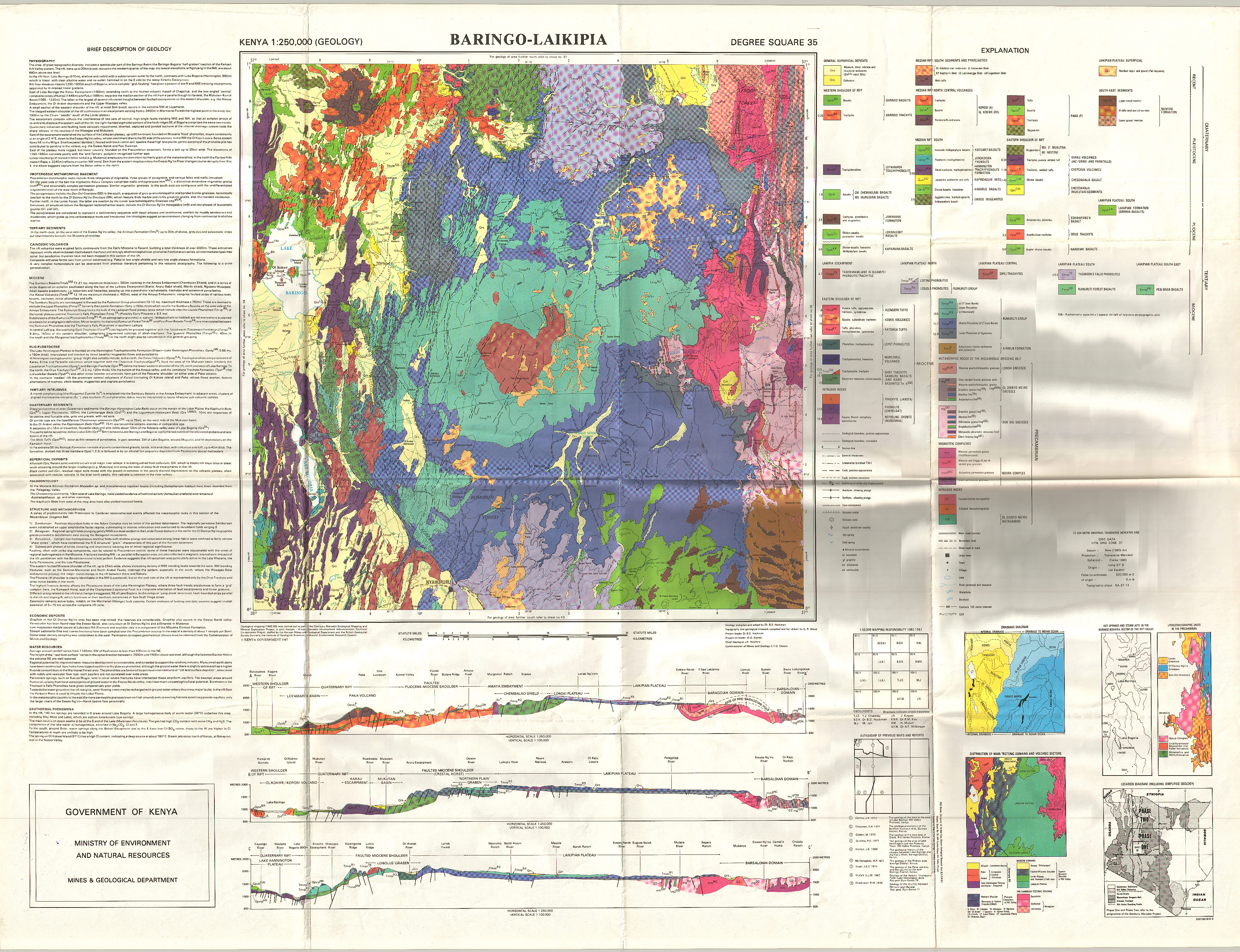
Geological map of Baringo - Laikipia (Degree square 35)
Scale: 1:250000,
Sheet number/quarter: Degree square 35
Year of publication: 1987
Filesize: 14,3 MB
Sheet number/quarter: Degree square 35
Year of publication: 1987
Filesize: 14,3 MB
Map coordinates
Top left: 1° 00' N, 36° 00' E
Top right: 1° 00' N, 37° 00' E
Bottom left: 0° 00' N, 37° 00' E
Bottom right: 0° 00' N, 36° 00' E
Top left: 1° 00' N, 36° 00' E
Top right: 1° 00' N, 37° 00' E
Bottom left: 0° 00' N, 37° 00' E
Bottom right: 0° 00' N, 36° 00' E
Mineral exploration and assesment of geological materials and geotourism sites in Alrmp project area, Baringo and East Pokot Districts
Year of publication: 2009
Filesize: 3,7 MB
Filesize: 3,7 MB
Geological map of Baringo - Laikipia
Scale: 1:250000,
Sheet number/quarter:
Year of publication: 1987
Filesize: 4,3 MB
Sheet number/quarter:
Year of publication: 1987
Filesize: 4,3 MB
Map coordinates
Top left: 3° 00' N, 37° 00' E
Top right: 3° 00' N, 38° 00' E
Bottom left: 0° 00' N, 37° 00' E
Bottom right: 2° 00' N, 37° 00' E
Top left: 3° 00' N, 37° 00' E
Top right: 3° 00' N, 38° 00' E
Bottom left: 0° 00' N, 37° 00' E
Bottom right: 2° 00' N, 37° 00' E
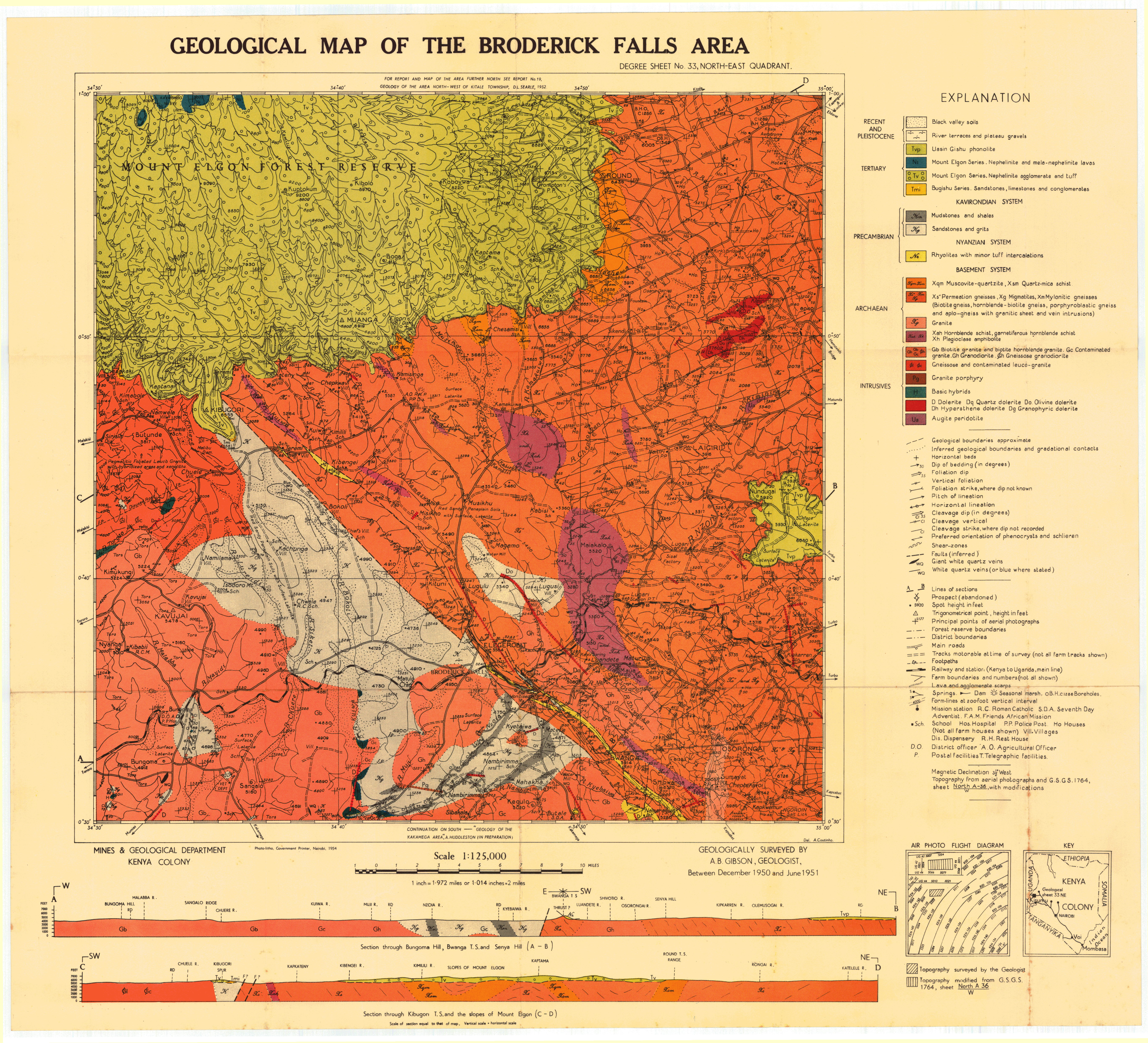
Geological map of the Broderick Falls area (33 NE)
Scale: 1:125000,
Sheet number/quarter: 33 NE
Year of publication: 1954
Filesize: 7,8 MB
Sheet number/quarter: 33 NE
Year of publication: 1954
Filesize: 7,8 MB
Map coordinates
Top left: 1° 00' N, 34° 30' E
Top right: 1° 00' N, 35° 00' E
Bottom left: 0° 30' N, 35° 00' E
Bottom right: 0° 30' N, 34° 30' E
Top left: 1° 00' N, 34° 30' E
Top right: 1° 00' N, 35° 00' E
Bottom left: 0° 30' N, 35° 00' E
Bottom right: 0° 30' N, 34° 30' E
Geological map of the Buna area (22)
Scale: 1:250000,
Sheet number/quarter: 22
Year of publication: 1970
Filesize: 5,8 MB
Sheet number/quarter: 22
Year of publication: 1970
Filesize: 5,8 MB
Map coordinates
Top left: 3° 00' N, 39° 00' E
Top right: 3° 00' N, 40° 00' E
Bottom left: 2° 00' N, 40° 00' E
Bottom right: 2° 00' N, 39° 00' E
Top left: 3° 00' N, 39° 00' E
Top right: 3° 00' N, 40° 00' E
Bottom left: 2° 00' N, 40° 00' E
Bottom right: 2° 00' N, 39° 00' E

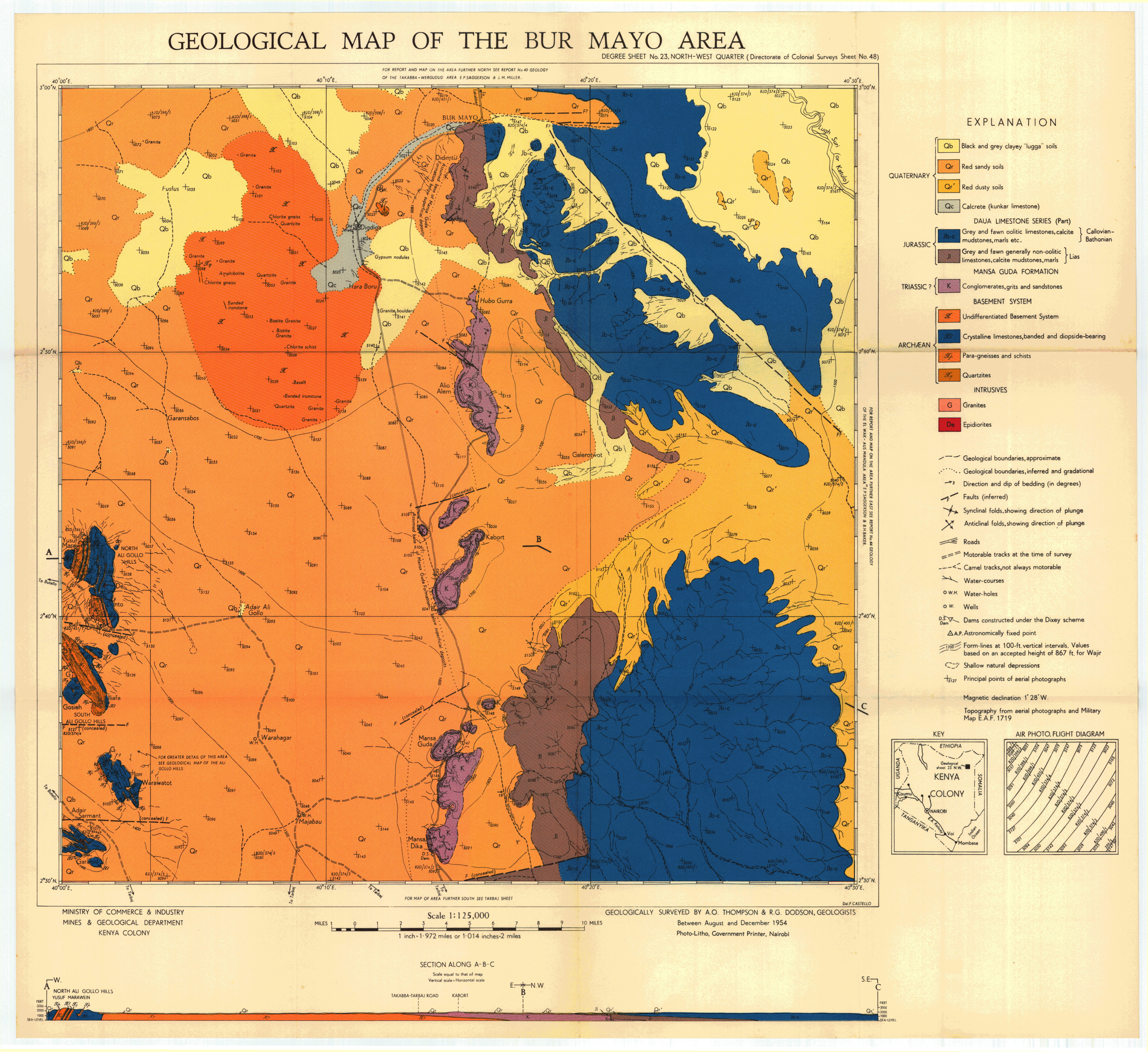
Geological map of the Bur Mayo area (23 NW)
Scale: 1:125000,
Sheet number/quarter: 23 NW
Year of publication: 1954
Filesize: 6,8 MB
Sheet number/quarter: 23 NW
Year of publication: 1954
Filesize: 6,8 MB
Map coordinates
Top left: 3° 00' N, 40° 00' E
Top right: 3° 00' N, 40° 30' E
Bottom left: 2° 30' N, 40° 30' E
Bottom right: 2° 30' N, 40° 00' E
Top left: 3° 00' N, 40° 00' E
Top right: 3° 00' N, 40° 30' E
Bottom left: 2° 30' N, 40° 30' E
Bottom right: 2° 30' N, 40° 00' E
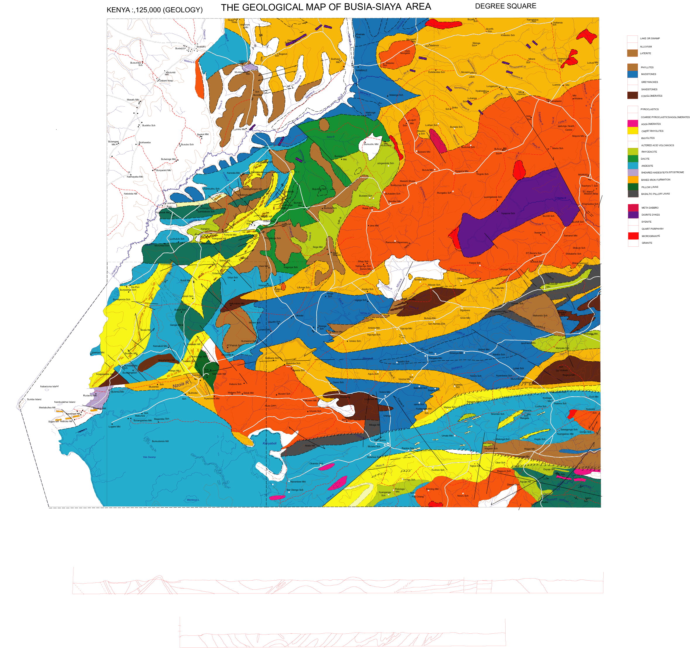
Geological map of Busia - Siaya area
Scale: 1:125000,
Sheet number/quarter:
Year of publication: n/a
Filesize: 1 MB
Sheet number/quarter:
Year of publication: n/a
Filesize: 1 MB
Map coordinates
Top left: N/A
Top right: N/A
Bottom left: N/A
Bottom right: N/A
Top left: N/A
Top right: N/A
Bottom left: N/A
Bottom right: N/A
Geological map of the Chanler's Falls area (37 NW)
Scale: 1:125000,
Sheet number/quarter: 37 NW
Year of publication: Between 1958 and 1959
Filesize: 7,9 MB
Sheet number/quarter: 37 NW
Year of publication: Between 1958 and 1959
Filesize: 7,9 MB
Map coordinates
Top left: 1° 00' N, 38° 00' E
Top right: 1° 00' N, 38° 30' E
Bottom left: 0° 30' N, 38° 30' E
Bottom right: 0° 30' N, 38° 00' E
Top left: 1° 00' N, 38° 00' E
Top right: 1° 00' N, 38° 30' E
Bottom left: 0° 30' N, 38° 30' E
Bottom right: 0° 30' N, 38° 00' E

Geological map of the Cherangani Hills area (26 SW)
Scale: 1:125000,
Sheet number/quarter: 26 SW
Year of publication: 1954
Filesize: 6,2 MB
Sheet number/quarter: 26 SW
Year of publication: 1954
Filesize: 6,2 MB
Map coordinates
Top left: 1° 30' N, 35° 00' E
Top right: 1° 30' N, 35° 30' E
Bottom left: 1° 00' N, 35° 30' E
Bottom right: 1° 00' N, 35° 00' E
Top left: 1° 30' N, 35° 00' E
Top right: 1° 30' N, 35° 30' E
Bottom left: 1° 00' N, 35° 30' E
Bottom right: 1° 00' N, 35° 00' E
Geological map of the Chyulu - Oloitoktok area (59 SE)
Scale: 1:125000,
Sheet number/quarter: 59 SE
Year of publication: 1988
Filesize: 5,3 MB
Sheet number/quarter: 59 SE
Year of publication: 1988
Filesize: 5,3 MB
Map coordinates
Top left: 2° 30' N, 37° 30' E
Top right: 2° 30' S, 38° 00' E
Bottom left: 3° 00' S, 38° 00' E
Bottom right: 3° 00' N, 37° 30' E
Top left: 2° 30' N, 37° 30' E
Top right: 2° 30' S, 38° 00' E
Bottom left: 3° 00' S, 38° 00' E
Bottom right: 3° 00' N, 37° 30' E
Geological map of the Chyulu - Oloitoktok area (59 SE)
Scale: 1:125000,
Sheet number/quarter: 59 SE
Year of publication: 1988
Filesize: 31,7 MB
Sheet number/quarter: 59 SE
Year of publication: 1988
Filesize: 31,7 MB
Map coordinates
Top left: 2° 30' N, 37° 30' E
Top right: 2° 30' S, 38° 00' E
Bottom left: 3° 00' S, 38° 00' E
Bottom right: 3° 00' N, 37° 30' E
Top left: 2° 30' N, 37° 30' E
Top right: 2° 30' S, 38° 00' E
Bottom left: 3° 00' S, 38° 00' E
Bottom right: 3° 00' N, 37° 30' E
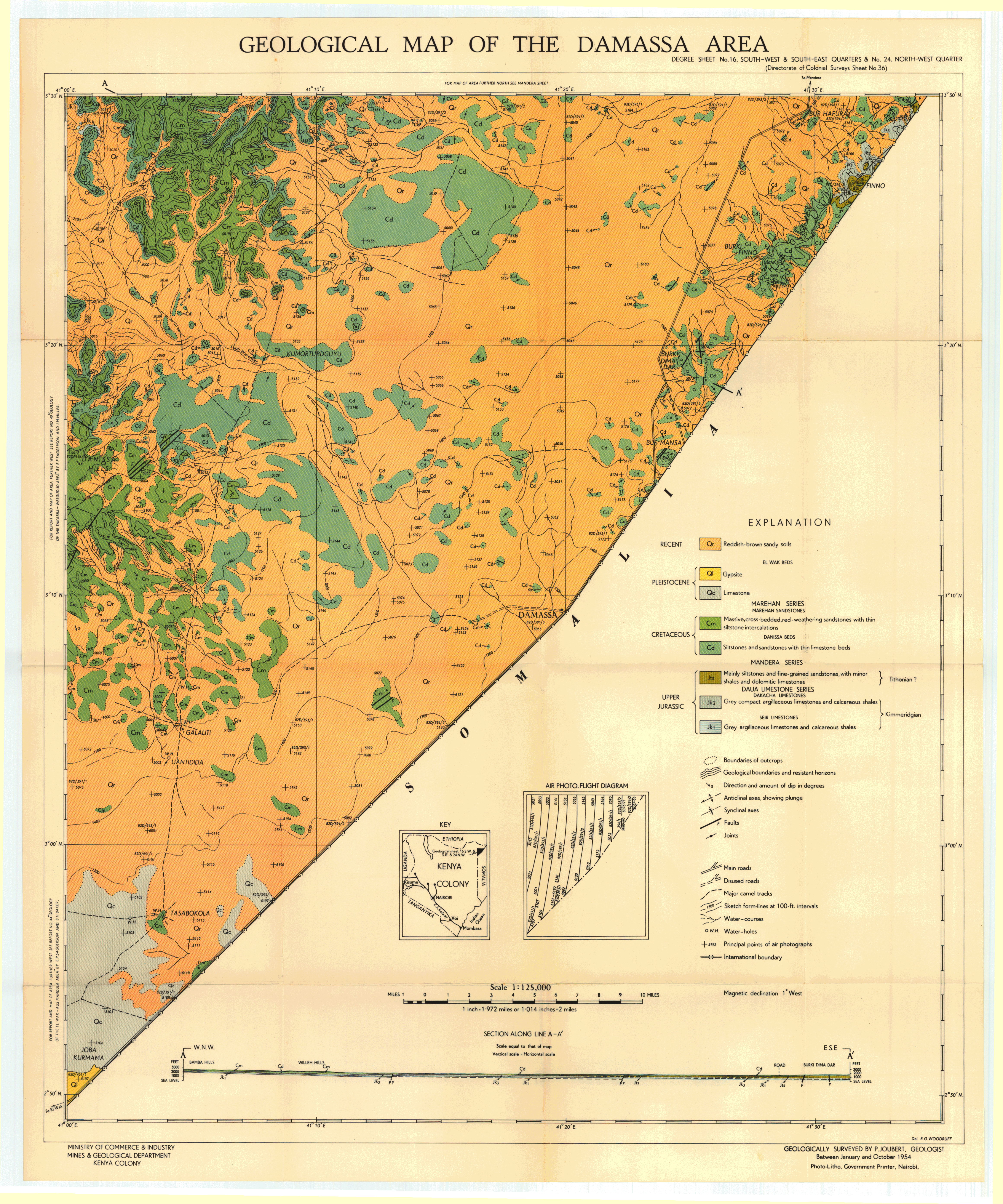
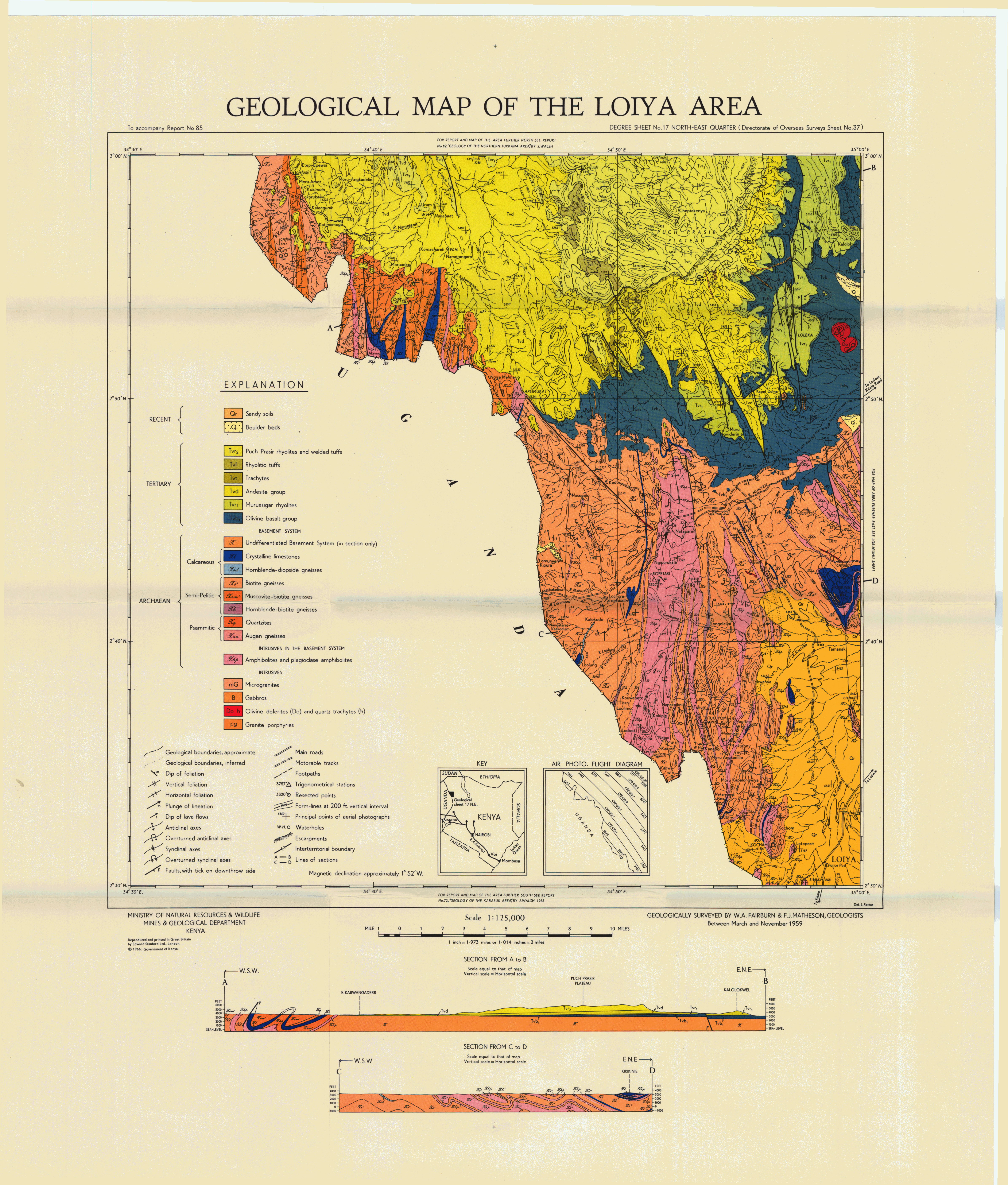
Geological map of the Damassa area (16 SW)
Scale: 1:125000,
Sheet number/quarter: 16 SW
Year of publication: 1954
Filesize: 7,3 MB
Sheet number/quarter: 16 SW
Year of publication: 1954
Filesize: 7,3 MB
Map coordinates
Top left: 3° 30' N, 41° 00' E
Top right: N/A
Bottom left: N/A
Bottom right: 2° 50' N, 41° 00' E
Top left: 3° 30' N, 41° 00' E
Top right: N/A
Bottom left: N/A
Bottom right: 2° 50' N, 41° 00' E
Geological map of the Derkali area (15 NW)
Scale: 1:125000,
Sheet number/quarter: 15 NW
Year of publication: 1953
Filesize: 6,3 MB
Sheet number/quarter: 15 NW
Year of publication: 1953
Filesize: 6,3 MB
Map coordinates
Top left: 4° 10' N, 40° 00' E
Top right: 4° 10' N, 40° 30' E
Bottom left: 3° 30' N, 40° 30' E
Bottom right: 3° 30' N, 40° 00' E
Top left: 4° 10' N, 40° 00' E
Top right: 4° 10' N, 40° 30' E
Bottom left: 3° 30' N, 40° 30' E
Bottom right: 3° 30' N, 40° 00' E

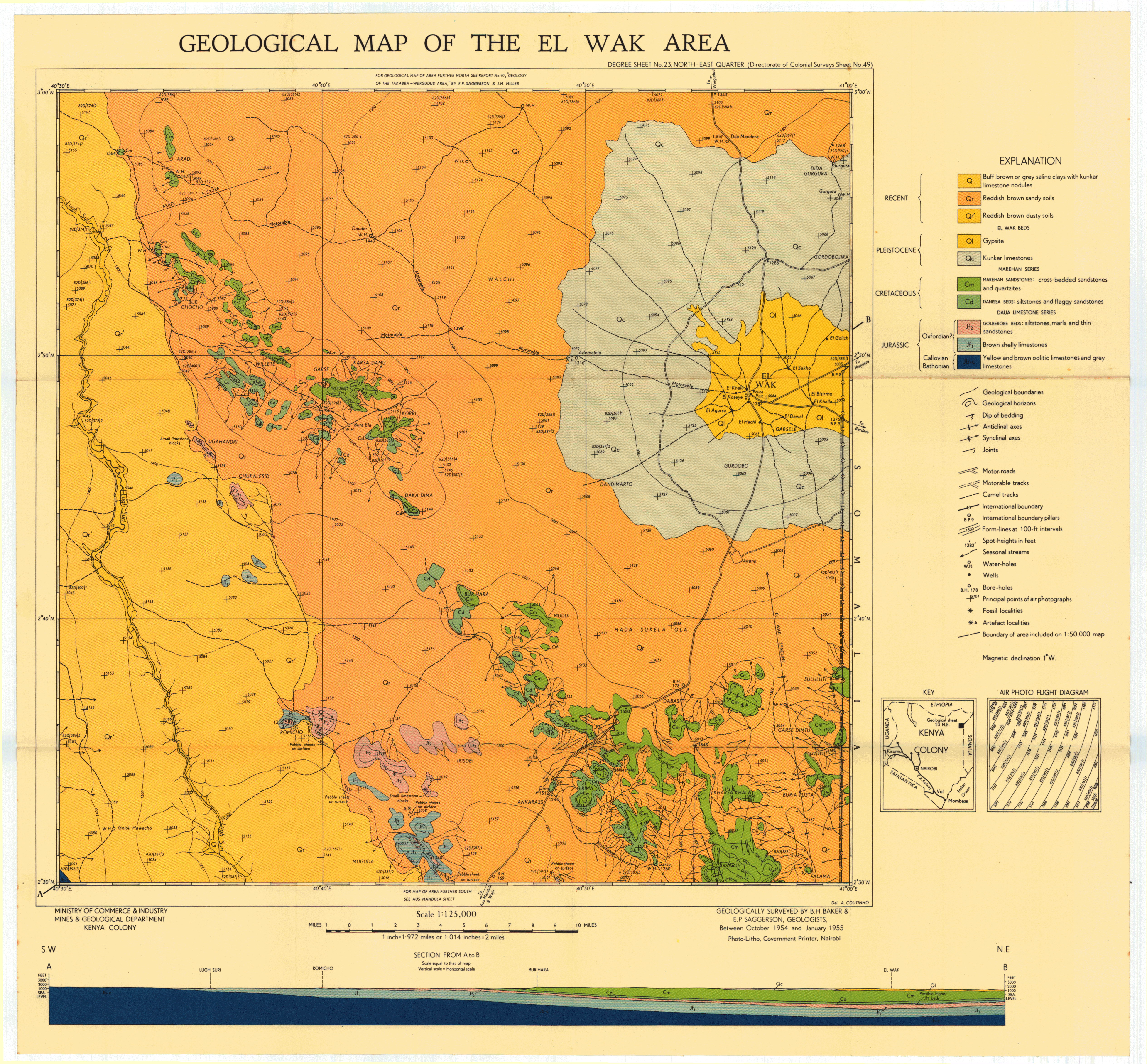
Geological map of the El Wak area (23 NE)
Scale: 1:125000,
Sheet number/quarter: 23 NE
Year of publication: 1955
Filesize: 6,8 MB
Sheet number/quarter: 23 NE
Year of publication: 1955
Filesize: 6,8 MB
Map coordinates
Top left: 3° 00' N, 40° 30' E
Top right: 3° 00' N, 41° 00' E
Bottom left: 2° 30' N, 41° 00' E
Bottom right: 2° 30' N, 40° 30' E
Top left: 3° 00' N, 40° 30' E
Top right: 3° 00' N, 41° 00' E
Bottom left: 2° 30' N, 41° 00' E
Bottom right: 2° 30' N, 40° 30' E
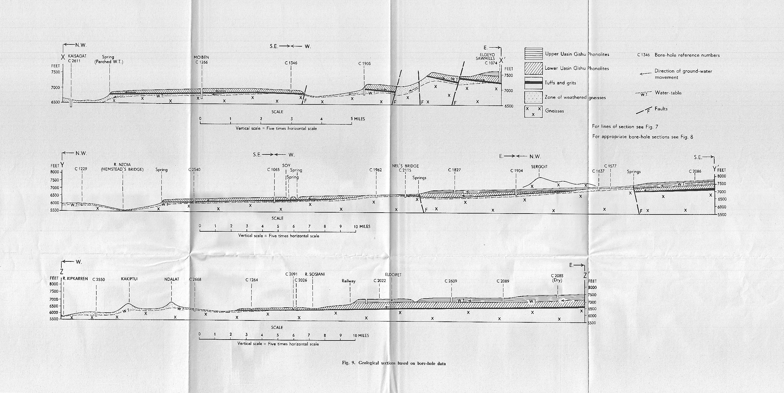
Geological map of the Eldama Ravine - Kabarnet area (34 SE)
Scale: 1:125000,
Sheet number/quarter: 34 SE
Year of publication: 1966
Filesize: 45,9 MB
Sheet number/quarter: 34 SE
Year of publication: 1966
Filesize: 45,9 MB
Map coordinates
Top left: 0° 30' N, 35° 30' E
Top right: 0° 30' N, 36° 00' E
Bottom left: 0° 00' N, 36° 00' E
Bottom right: 0° 00' N, 35° 30' E
Top left: 0° 30' N, 35° 30' E
Top right: 0° 30' N, 36° 00' E
Bottom left: 0° 00' N, 36° 00' E
Bottom right: 0° 00' N, 35° 30' E
Geological map of the Eldama Ravine - Kabarnet area (35 SE)
Scale: 1:125000,
Sheet number/quarter: 35 SE
Year of publication: 1966
Filesize: 7,4 MB
Sheet number/quarter: 35 SE
Year of publication: 1966
Filesize: 7,4 MB
Map coordinates
Top left: 0° 30' N, 35° 30' E
Top right: 0° 30' N, 36° 00' E
Bottom left: 0° 00' N, 36° 00' E
Bottom right: 0° 00' N, 35° 30' E
Top left: 0° 30' N, 35° 30' E
Top right: 0° 30' N, 36° 00' E
Bottom left: 0° 00' N, 36° 00' E
Bottom right: 0° 00' N, 35° 30' E
Geological map of the Eldama Ravine - Kabarnet area (34 SE)
Scale: 1:125000,
Sheet number/quarter: 34 SE
Year of publication: 1966
Filesize: 3 MB
Sheet number/quarter: 34 SE
Year of publication: 1966
Filesize: 3 MB
Map coordinates
Top left: 0° 30' N, 35° 30' E
Top right: 0° 30' N, 36° 00' E
Bottom left: 0° 00' N, 36° 00' E
Bottom right: 0° 00' N, 35° 30' E
Top left: 0° 30' N, 35° 30' E
Top right: 0° 30' N, 36° 00' E
Bottom left: 0° 00' N, 36° 00' E
Bottom right: 0° 00' N, 35° 30' E

Geological map of the Eldama Ravine - Kabarnet area (34 SE)
Scale: 1:125000,
Sheet number/quarter: 34 SE
Year of publication: 1966
Filesize: 10,1 MB
Sheet number/quarter: 34 SE
Year of publication: 1966
Filesize: 10,1 MB
Map coordinates
Top left: 0° 30' N, 35° 30' E
Top right: 0° 30' N, 36° 00' E
Bottom left: 0° 00' N, 36° 00' E
Bottom right: 0° 00' N, 35° 30' E
Top left: 0° 30' N, 35° 30' E
Top right: 0° 30' N, 36° 00' E
Bottom left: 0° 00' N, 36° 00' E
Bottom right: 0° 00' N, 35° 30' E
Geological map of the Eldama Ravine - Kabarnet area (34 SE)
Scale: 1:125000,
Sheet number/quarter: 34 SE
Year of publication: 1966
Filesize: 5,7 MB
Sheet number/quarter: 34 SE
Year of publication: 1966
Filesize: 5,7 MB
Map coordinates
Top left: 0° 30' N, 35° 30' E
Top right: 0° 30' N, 36° 00' E
Bottom left: 0° 00' N, 36° 00' E
Bottom right: 0° 00' N, 35° 30' E
Top left: 0° 30' N, 35° 30' E
Top right: 0° 30' N, 36° 00' E
Bottom left: 0° 00' N, 36° 00' E
Bottom right: 0° 00' N, 35° 30' E
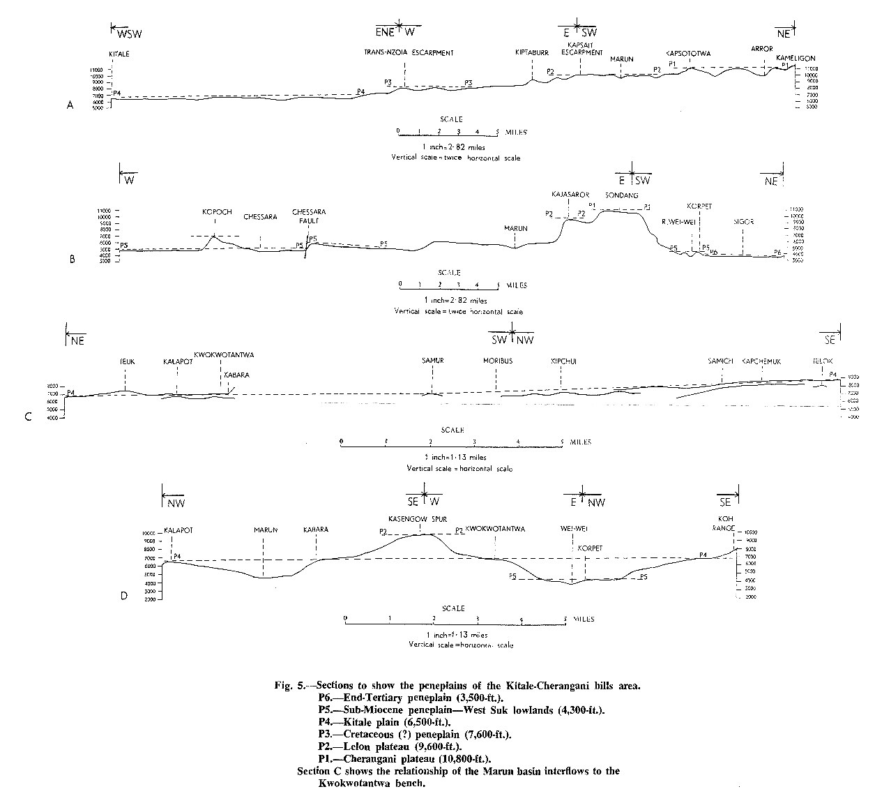
Eldoret - Sections to show the Peneplains of the Kitale-Cherangani Hills Area
Year of publication: N/A
Filesize: 0,2 MB
Filesize: 0,2 MB
Geological map of the Eldoret area (34 NW)
Scale: 1:125000,
Sheet number/quarter: 34 NW
Year of publication: 1964
Filesize: 6,3 MB
Sheet number/quarter: 34 NW
Year of publication: 1964
Filesize: 6,3 MB
Map coordinates
Top left: 1° 00' N, 35° 00' E
Top right: 1° 00' N, 35° 30' E
Bottom left: 0° 30' N, 35° 30' E
Bottom right: 0° 30' N, 35° 00' E
Top left: 1° 00' N, 35° 00' E
Top right: 1° 00' N, 35° 30' E
Bottom left: 0° 30' N, 35° 30' E
Bottom right: 0° 30' N, 35° 00' E

Geological map of the Eldoret area (34 NW)
Scale: 1:125000,
Sheet number/quarter: 34 NW
Year of publication: 1964
Filesize: 44,9 MB
Sheet number/quarter: 34 NW
Year of publication: 1964
Filesize: 44,9 MB
Map coordinates
Top left: 1° 00' N, 35° 00' E
Top right: 1° 00' N, 35° 30' E
Bottom left: 0° 30' N, 35° 30' E
Bottom right: 0° 30' N, 35° 00' E
Top left: 1° 00' N, 35° 00' E
Top right: 1° 00' N, 35° 30' E
Bottom left: 0° 30' N, 35° 30' E
Bottom right: 0° 30' N, 35° 00' E
Geological map of the Eldoret area (34 NW)
Scale: 1:125000,
Sheet number/quarter: 34 NW
Year of publication: 1964
Filesize: 2,7 MB
Sheet number/quarter: 34 NW
Year of publication: 1964
Filesize: 2,7 MB
Map coordinates
Top left: 1° 00' N, 35° 00' E
Top right: 1° 00' N, 35° 30' E
Bottom left: 0° 30' N, 35° 30' E
Bottom right: 0° 30' N, 35° 00' E
Top left: 1° 00' N, 35° 00' E
Top right: 1° 00' N, 35° 30' E
Bottom left: 0° 30' N, 35° 30' E
Bottom right: 0° 30' N, 35° 00' E

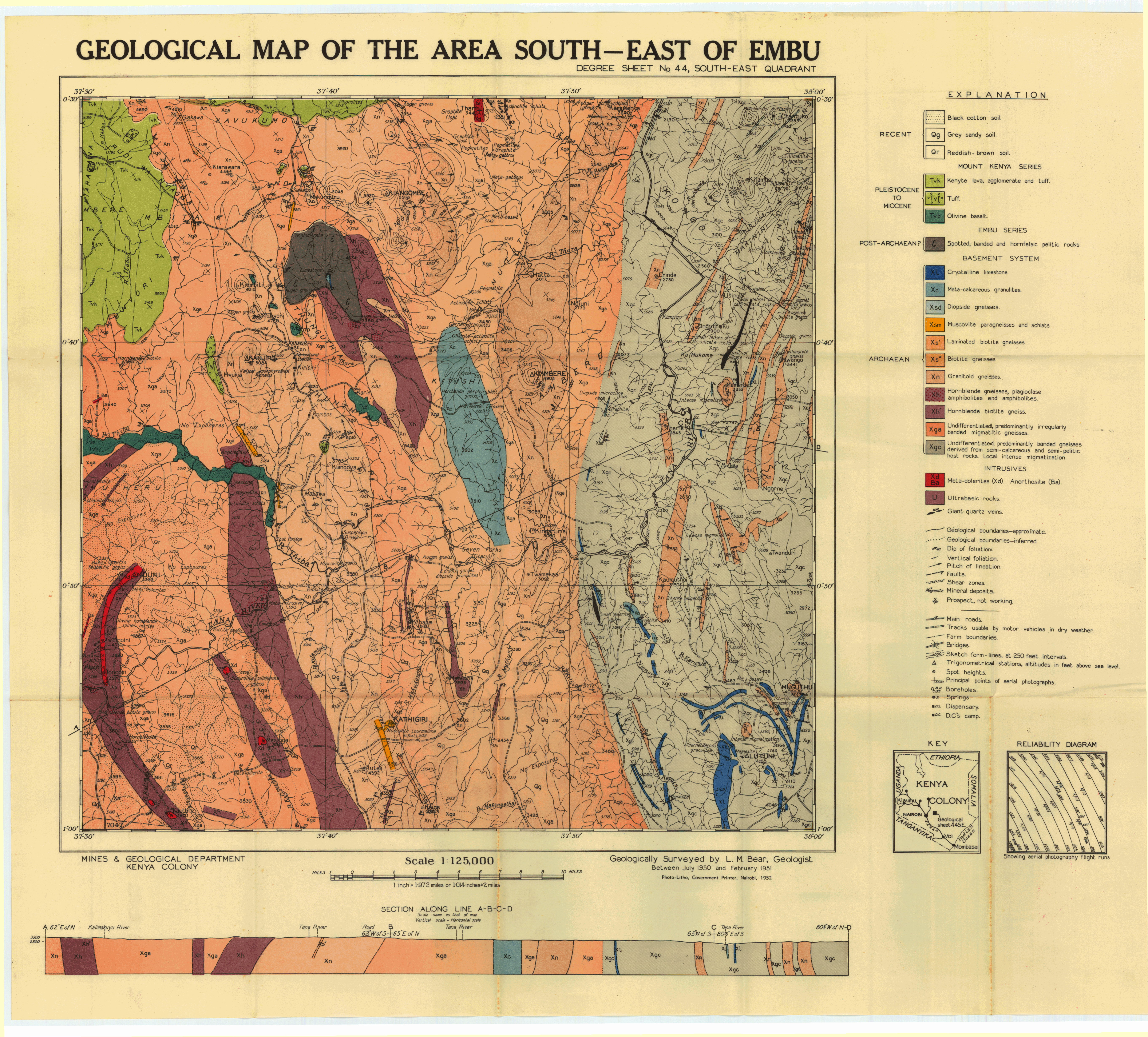
Geological map of the area South East of Embu (44 SE)
Scale: 1:125000,
Sheet number/quarter: 44 SE
Year of publication: 1952
Filesize: 45,4 MB
Sheet number/quarter: 44 SE
Year of publication: 1952
Filesize: 45,4 MB
Map coordinates
Top left: 0° 30' S, 37° 30' E
Top right: 0° 30' S, 38° 00' E
Bottom left: 1° 00' S, 38° 00' E
Bottom right: 1° 00' S, 37° 30' E
Top left: 0° 30' S, 37° 30' E
Top right: 0° 30' S, 38° 00' E
Bottom left: 1° 00' S, 38° 00' E
Bottom right: 1° 00' S, 37° 30' E

Geological map of the area South East of Embu (44 SE)
Scale: 1:125000,
Sheet number/quarter: 44 SE
Year of publication: 1952
Filesize: 6,5 MB
Sheet number/quarter: 44 SE
Year of publication: 1952
Filesize: 6,5 MB
Map coordinates
Top left: 0° 30' S, 37° 30' E
Top right: 0° 30' S, 38° 00' E
Bottom left: 1° 00' S, 38° 00' E
Bottom right: 1° 00' S, 37° 30' E
Top left: 0° 30' S, 37° 30' E
Top right: 0° 30' S, 38° 00' E
Bottom left: 1° 00' S, 38° 00' E
Bottom right: 1° 00' S, 37° 30' E
Geological reconnaissance of the country between embu and meru
Year of publication: 1951
Filesize: 2,6 MB
Filesize: 2,6 MB
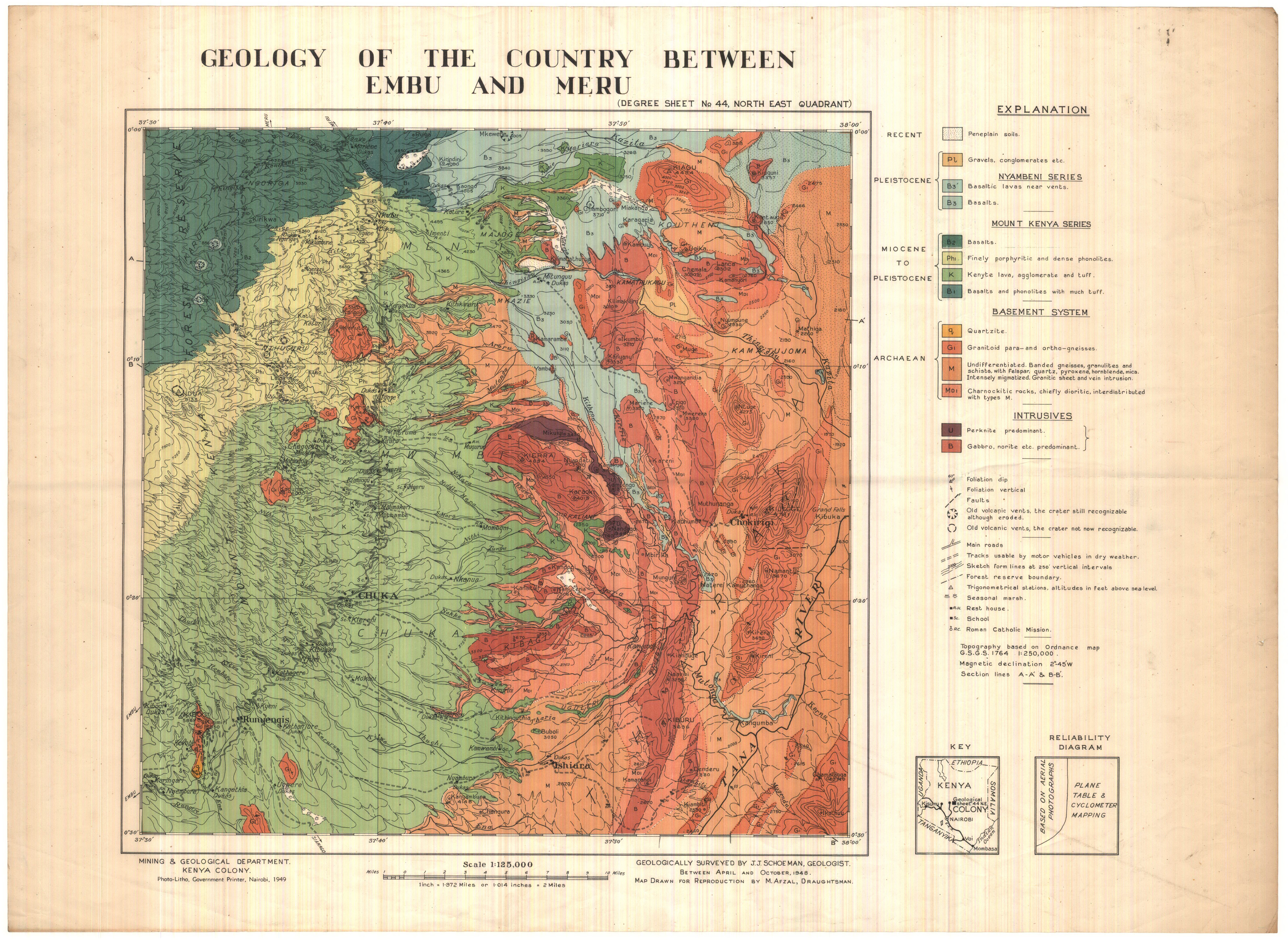
Geology of the country between Embu and Meru (44 NE)
Scale: 1:125000,
Sheet number/quarter: 44 NE
Year of publication: 1949
Filesize: 5,1 MB
Sheet number/quarter: 44 NE
Year of publication: 1949
Filesize: 5,1 MB
Map coordinates
Top left: 0° 00' S, 37° 30' E
Top right: 0° 00' S, 38° 00' E
Bottom left: 0° 30' S, 38° 00' E
Bottom right: 0° 30' S, 37° 30' E
Top left: 0° 00' S, 37° 30' E
Top right: 0° 00' S, 38° 00' E
Bottom left: 0° 30' S, 38° 00' E
Bottom right: 0° 30' S, 37° 30' E
Geological map of the Endau area (53 NE)
Scale: 1:125000,
Sheet number/quarter: 53 NE
Year of publication: 1964
Filesize: 5,6 MB
Sheet number/quarter: 53 NE
Year of publication: 1964
Filesize: 5,6 MB
Map coordinates
Top left: 1° 00' S, 38° 30' E
Top right: 1° 00' S, 39° 00' E
Bottom left: 1° 30' S, 39° 00' E
Bottom right: 1° 30' S, 38° 30' E
Top left: 1° 00' S, 38° 30' E
Top right: 1° 00' S, 39° 00' E
Bottom left: 1° 30' S, 39° 00' E
Bottom right: 1° 30' S, 38° 30' E

Geological map of the Enyali (Nyali) area (53 SE)
Scale: 1:125000,
Sheet number/quarter: 53 SE
Year of publication: 1964
Filesize: 7,2 MB
Sheet number/quarter: 53 SE
Year of publication: 1964
Filesize: 7,2 MB
Map coordinates
Top left: 1° 30' S, 38° 30' E
Top right: 1° 30' S, 39° 00' E
Bottom left: 2° 00' S, 38° 30' E
Bottom right: 2° 00' S, 39° 00' E
Top left: 1° 30' S, 38° 30' E
Top right: 1° 30' S, 39° 00' E
Bottom left: 2° 00' S, 38° 30' E
Bottom right: 2° 00' S, 39° 00' E

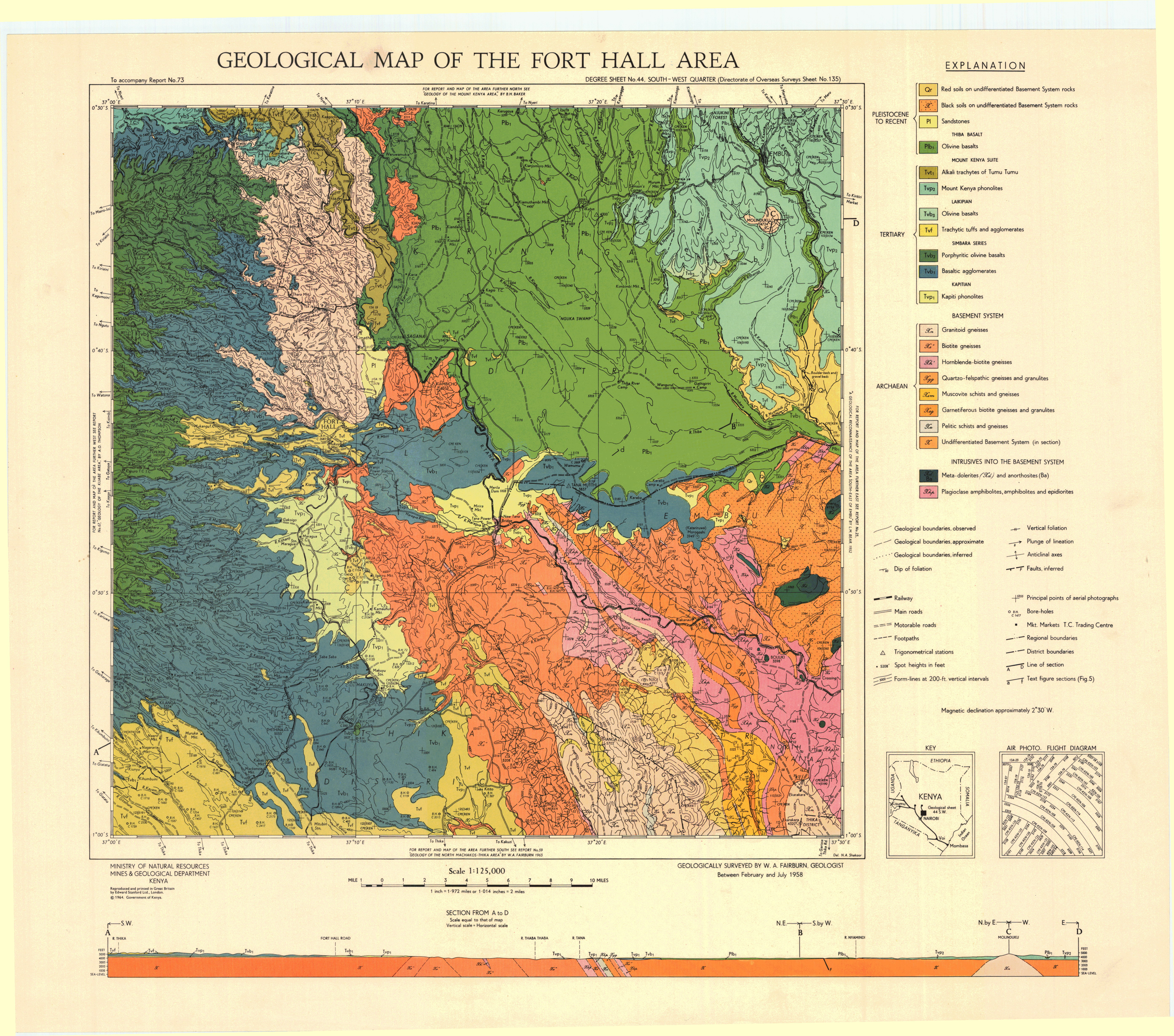
Geological map of the Fort Hall area (44 SW)
Scale: 1:125000,
Sheet number/quarter: 44 SW
Year of publication: 1964
Filesize: 7,7 MB
Sheet number/quarter: 44 SW
Year of publication: 1964
Filesize: 7,7 MB
Map coordinates
Top left: 0° 30' S, 37° 00' E
Top right: 0° 30' S, 37° 30' E
Bottom left: 1° 00' S, 37° 30' E
Bottom right: 1° 00' S, 37° 00' E
Top left: 0° 30' S, 37° 00' E
Top right: 0° 30' S, 37° 30' E
Bottom left: 1° 00' S, 37° 30' E
Bottom right: 1° 00' S, 37° 00' E
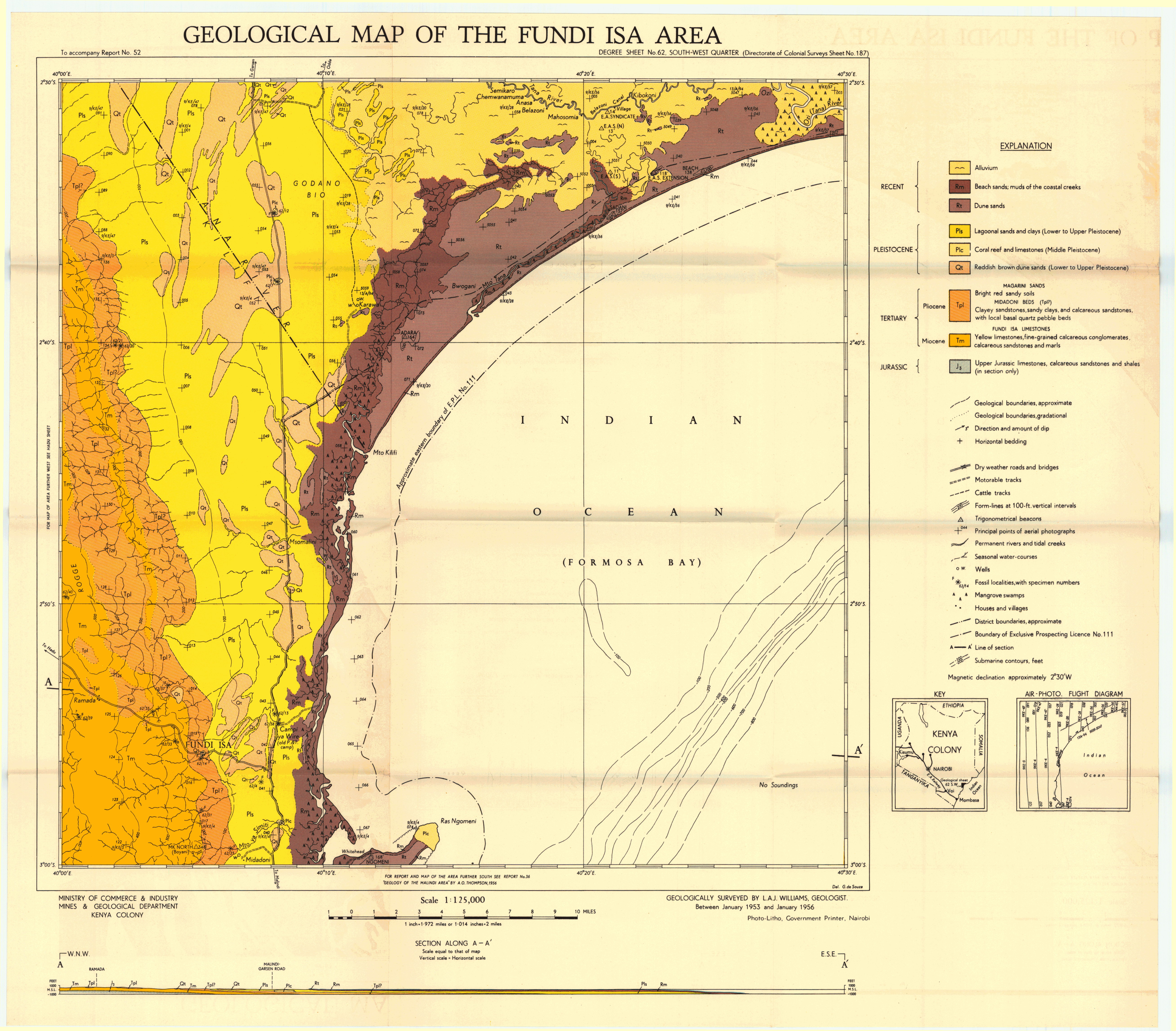
Geological map of the Fundi Isa area (62 SW)
Scale: 1:125000,
Sheet number/quarter: 62 SW
Year of publication: Between 1953 and 1956
Filesize: 4,6 MB
Sheet number/quarter: 62 SW
Year of publication: Between 1953 and 1956
Filesize: 4,6 MB
Map coordinates
Top left: 2° 30' S, 40° 00' E
Top right: 2° 30' S, 40° 30' E
Bottom left: 3° 00' S, 40° 30' E
Bottom right: 3° 00' S, 40° 00' E
Top left: 2° 30' S, 40° 00' E
Top right: 2° 30' S, 40° 30' E
Bottom left: 3° 00' S, 40° 30' E
Bottom right: 3° 00' S, 40° 00' E
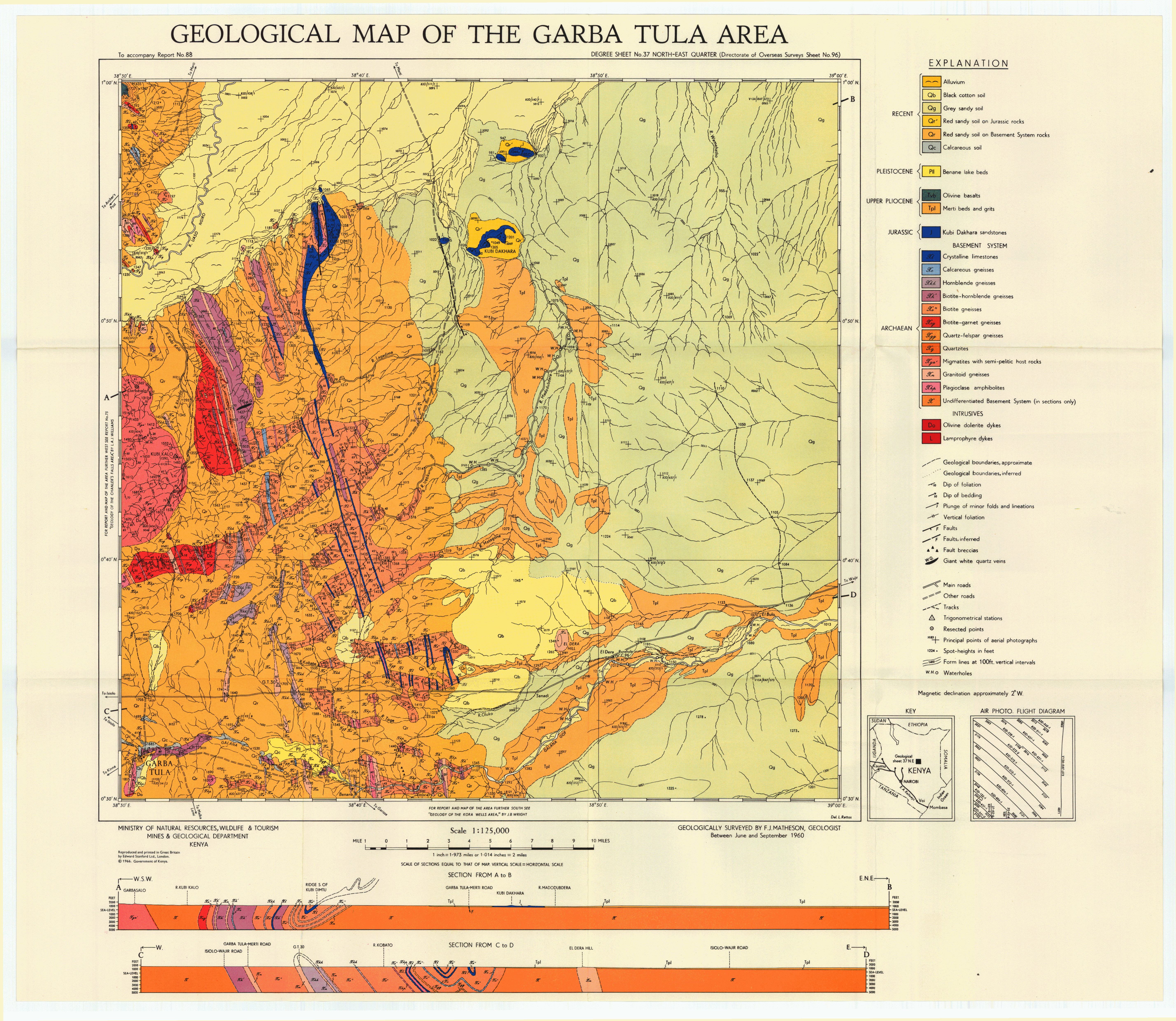
Geological map of the Garba Tula area (37 NE)
Scale: 1:125000,
Sheet number/quarter: 37 NE
Year of publication: 1966
Filesize: 6,7 MB
Sheet number/quarter: 37 NE
Year of publication: 1966
Filesize: 6,7 MB
Map coordinates
Top left: 1° 00' N, 38° 30' E
Top right: 1° 00' N, 39° 00' E
Bottom left: 0° 30' N, 39° 00' E
Bottom right: 0° 30' N, 38° 00' E
Top left: 1° 00' N, 38° 30' E
Top right: 1° 00' N, 39° 00' E
Bottom left: 0° 30' N, 39° 00' E
Bottom right: 0° 30' N, 38° 00' E
Gwasi - Diagramatic sketch ,illustrating the evolution of the Rangwa complex and the Kisingiri volcano
Year of publication: N/A
Filesize: 0,4 MB
Filesize: 0,4 MB

Gwasi - Fig 1. Panorama of the Rangwa vent taken from Sagarumi, in the North East. Fig 2. Sketch of the panorama of fig 1, showing the rock types
Year of publication: N/A
Filesize: 0,8 MB
Filesize: 0,8 MB

Gwasi - Fig 10. Panorama of Rangwaand Gembe looking east from Bukula point. Fig 11. Diagramatic section of the Rangwa alkaline ring complex
Year of publication: N/A
Filesize: 0,5 MB
Filesize: 0,5 MB

Geological map of the Gwasi area (41 SW)
Scale: 1:125000,
Sheet number/quarter: 41 SW
Year of publication: 1954
Filesize: 7,9 MB
Sheet number/quarter: 41 SW
Year of publication: 1954
Filesize: 7,9 MB
Map coordinates
Top left: 0° 20' S, 34° 00' E
Top right: 0° 20' S, 34° 30' E
Bottom left: 1° 00' S, 34° 30' E
Bottom right: 1° 00' S, 34° 00' E
Top left: 0° 20' S, 34° 00' E
Top right: 0° 20' S, 34° 30' E
Bottom left: 1° 00' S, 34° 30' E
Bottom right: 1° 00' S, 34° 00' E

Geological map of the Gwasi area (41 SW)
Scale: 1:125000,
Sheet number/quarter: 41 SW
Year of publication: 1954
Filesize: 2,8 MB
Sheet number/quarter: 41 SW
Year of publication: 1954
Filesize: 2,8 MB
Map coordinates
Top left: 0° 20' S, 34° 00' E
Top right: 0° 20' S, 34° 30' E
Bottom left: 1° 00' S, 34° 30' E
Bottom right: 1° 00' S, 34° 00' E
Top left: 0° 20' S, 34° 00' E
Top right: 0° 20' S, 34° 30' E
Bottom left: 1° 00' S, 34° 30' E
Bottom right: 1° 00' S, 34° 00' E

Geological map of the Hadu area (61 SE)
Scale: 1:125000,
Sheet number/quarter: 61 SE
Year of publication: Between 1953 and 1956
Filesize: 6,9 MB
Sheet number/quarter: 61 SE
Year of publication: Between 1953 and 1956
Filesize: 6,9 MB
Map coordinates
Top left: 2° 30' S, 39° 30' E
Top right: 2° 30' S, 40° 00' E
Bottom left: 3° 00' S, 40° 00' E
Bottom right: 3° 00' S, 39° 30' E
Top left: 2° 30' S, 39° 30' E
Top right: 2° 30' S, 40° 00' E
Bottom left: 3° 00' S, 40° 00' E
Bottom right: 3° 00' S, 39° 30' E

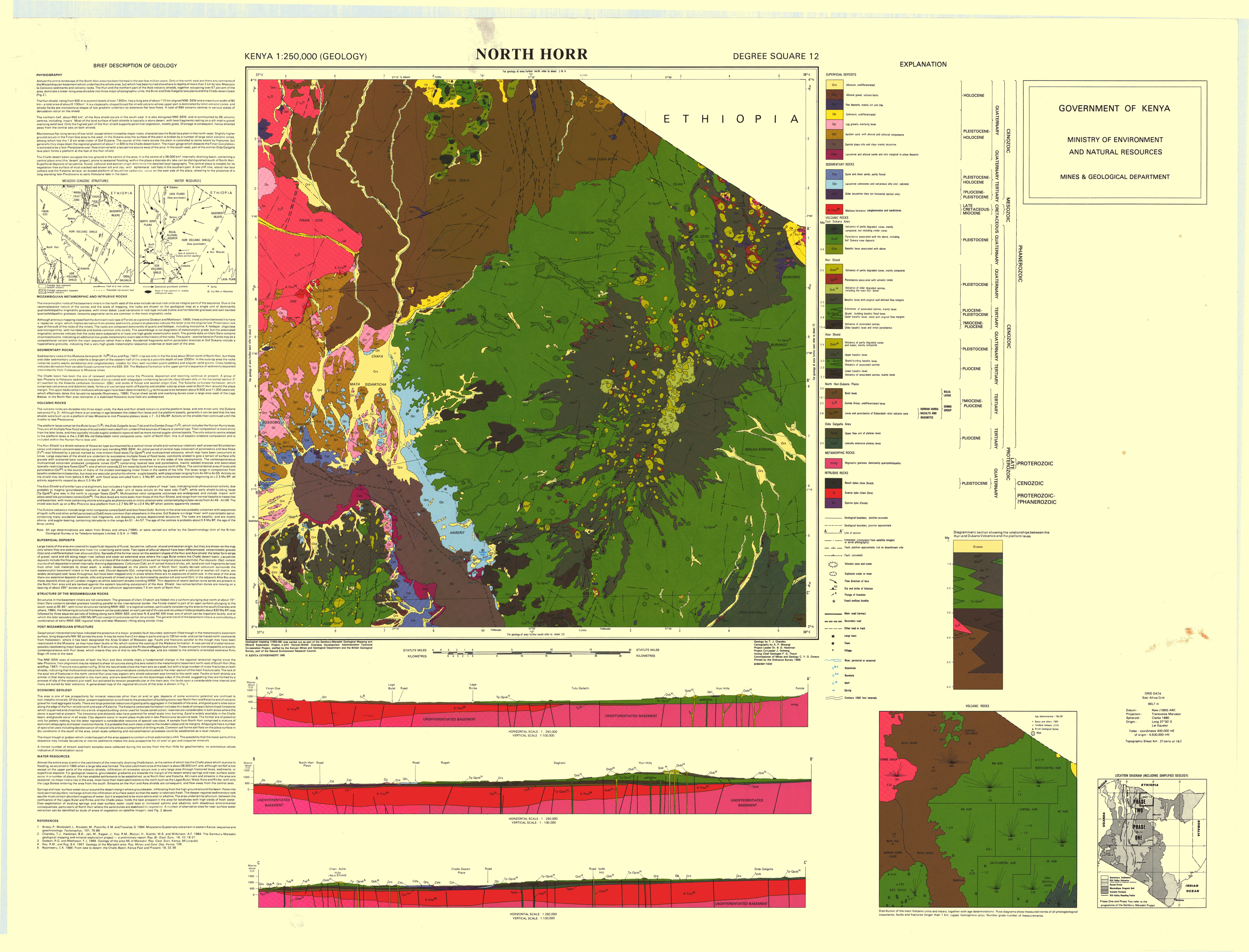
North Horr (Degree square 12)
Scale: 1:250000,
Sheet number/quarter: Degree square 12
Year of publication: 1988
Filesize: 7,6 MB
Sheet number/quarter: Degree square 12
Year of publication: 1988
Filesize: 7,6 MB
Map coordinates
Top left: 4° 00' N, 37° 00' E
Top right: 4° 00' N, 38° 00' E
Bottom left: 3° 00' N, 38° 00' E
Bottom right: 3° 00' N, 37° 00' E
Top left: 4° 00' N, 37° 00' E
Top right: 4° 00' N, 38° 00' E
Bottom left: 3° 00' N, 38° 00' E
Bottom right: 3° 00' N, 37° 00' E
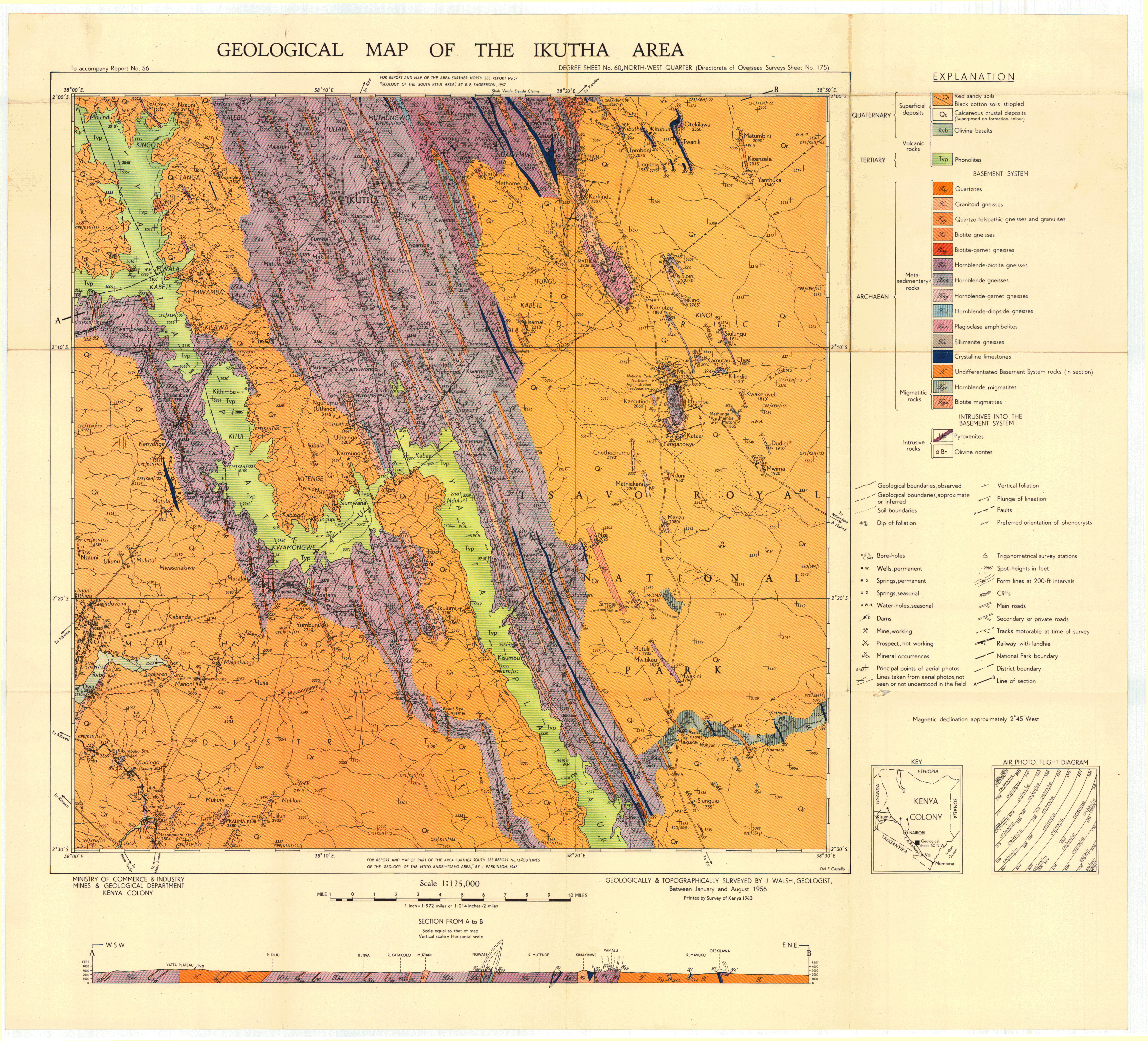
Geological map of the Ikutha area (60 NW)
Scale: 1:125000,
Sheet number/quarter: 60 NW
Year of publication: 1956
Filesize: 8,5 MB
Sheet number/quarter: 60 NW
Year of publication: 1956
Filesize: 8,5 MB
Map coordinates
Top left: 2° 00' S, 38° 00' E
Top right: 2° 00' S, 38° 30' E
Bottom left: 2° 30' S, 38° 30' E
Bottom right: 2° 30' S, 38° 00' E
Top left: 2° 00' S, 38° 00' E
Top right: 2° 00' S, 38° 30' E
Bottom left: 2° 30' S, 38° 30' E
Bottom right: 2° 30' S, 38° 00' E
Isiolo (Degree Square 36)
Scale: 1:250000,
Sheet number/quarter: Degree Square 36
Year of publication: 1986
Filesize: 11,2 MB
Sheet number/quarter: Degree Square 36
Year of publication: 1986
Filesize: 11,2 MB
Map coordinates
Top left: 1° 00' N, 37° 00' E
Top right: 1° 00' N, 38° 00' E
Bottom left: 0° 00' N, 38° 00' E
Bottom right: 0° 00' N, 37° 00' E
Top left: 1° 00' N, 37° 00' E
Top right: 1° 00' N, 38° 00' E
Bottom left: 0° 00' N, 38° 00' E
Bottom right: 0° 00' N, 37° 00' E

Geological map of the Kajiado area (51 SE)
Scale: 1:125000,
Sheet number/quarter: 51 SE
Year of publication: 1964
Filesize: 6,6 MB
Sheet number/quarter: 51 SE
Year of publication: 1964
Filesize: 6,6 MB
Map coordinates
Top left: 1° 30' S, 36° 27' E
Top right: 1° 30' S, 37° 00' E
Bottom left: 2° 00' S, 36° 27' E
Bottom right: 2° 00' S, 37° 00' E
Top left: 1° 30' S, 36° 27' E
Top right: 1° 30' S, 37° 00' E
Bottom left: 2° 00' S, 36° 27' E
Bottom right: 2° 00' S, 37° 00' E

Geological map of the Kajiado area (51 SE)
Scale: 1:125000,
Sheet number/quarter: 51 SE
Year of publication: 1964
Filesize: 2,9 MB
Sheet number/quarter: 51 SE
Year of publication: 1964
Filesize: 2,9 MB
Map coordinates
Top left: 2° 30' S, 36° 27' E
Top right: 2° 30' S, 37° 00' E
Bottom left: 3° 00' S, 36° 27' E
Bottom right: 3° 00' S, 37° 00' E
Top left: 2° 30' S, 36° 27' E
Top right: 2° 30' S, 37° 00' E
Bottom left: 3° 00' S, 36° 27' E
Bottom right: 3° 00' S, 37° 00' E

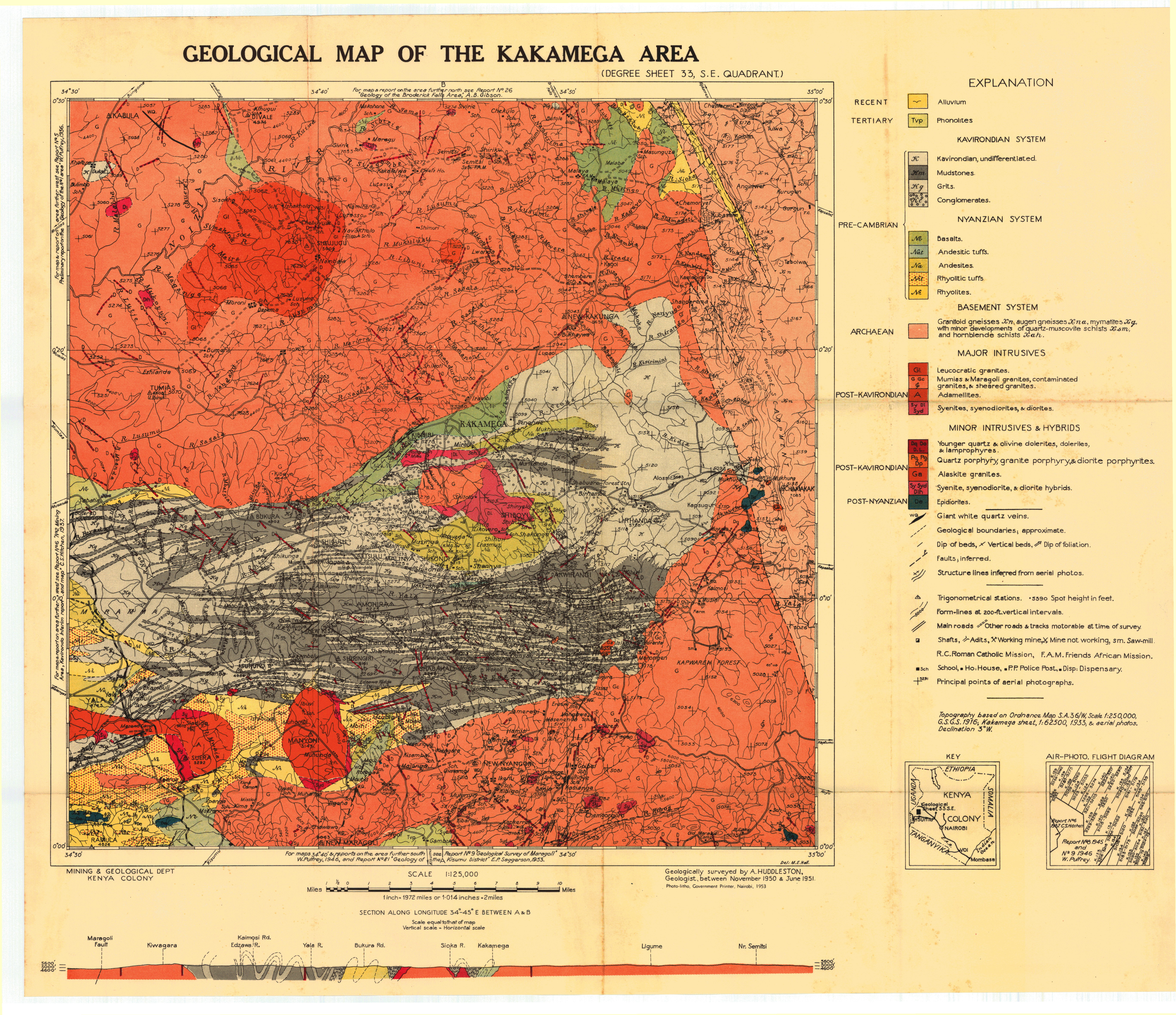
Geological map of the Kakamega area (33SE)
Scale: 1:125000,
Sheet number/quarter: 33SE
Year of publication: 1953
Filesize: 2,8 MB
Sheet number/quarter: 33SE
Year of publication: 1953
Filesize: 2,8 MB
Map coordinates
Top left: 0° 30' N, 34° 30' E
Top right: 0° 30' N, 35° 00' E
Bottom left: 0° 00' N, 35° 00' E
Bottom right: 0° 00' N, 34° 30' E
Top left: 0° 30' N, 34° 30' E
Top right: 0° 30' N, 35° 00' E
Bottom left: 0° 00' N, 35° 00' E
Bottom right: 0° 00' N, 34° 30' E
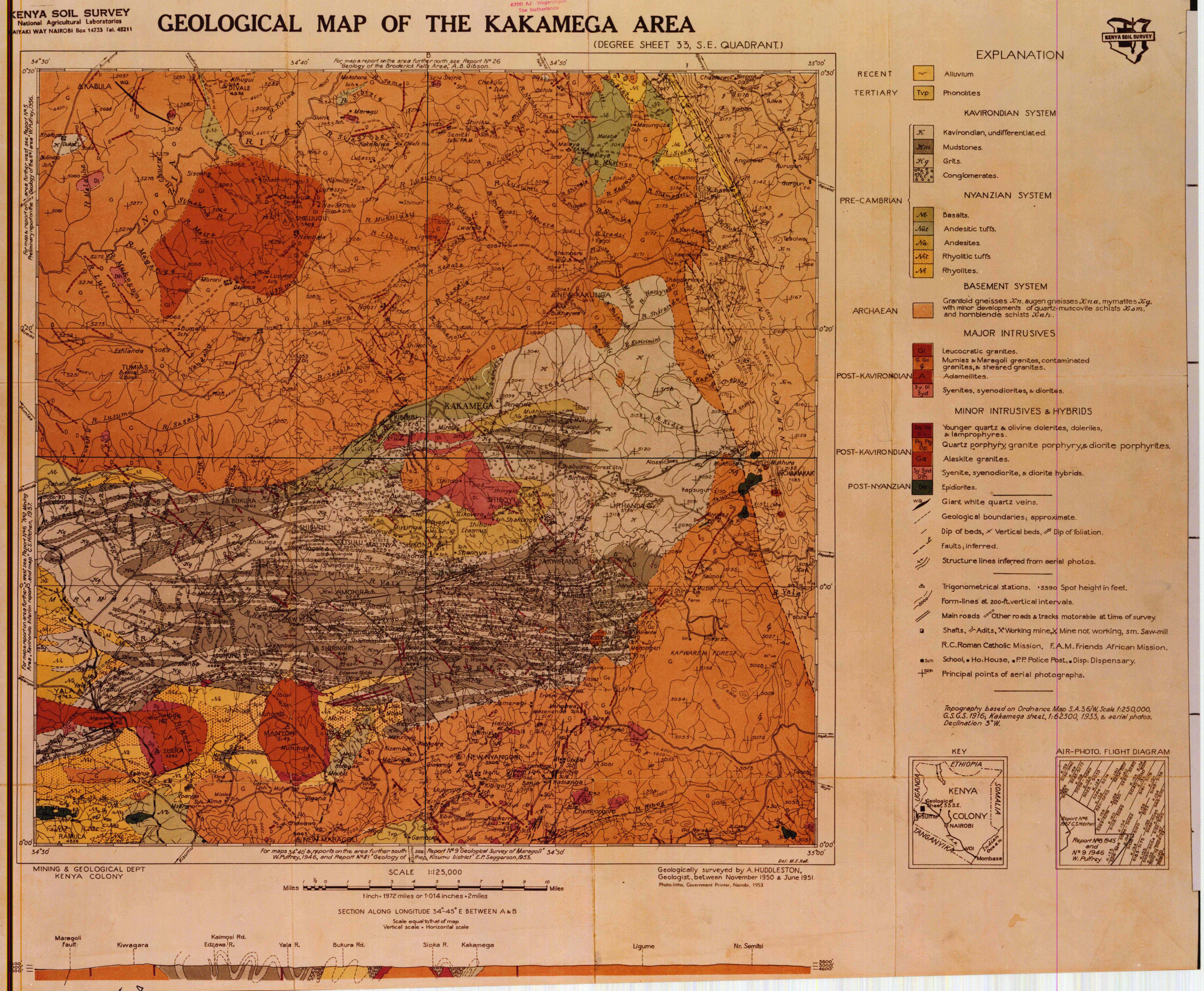
Geological map of the Kakamega area (33 SE)
Scale: 1:125000,
Sheet number/quarter: 33 SE
Year of publication: 1953
Filesize: 7,6 MB
Sheet number/quarter: 33 SE
Year of publication: 1953
Filesize: 7,6 MB
Map coordinates
Top left: 0° 30' N, 34° 30' E
Top right: 0° 30' N, 35° 00' E
Bottom left: 0° 00' N, 35° 00' E
Bottom right: 0° 00' N, 34° 30' E
Top left: 0° 30' N, 34° 30' E
Top right: 0° 30' N, 35° 00' E
Bottom left: 0° 00' N, 35° 00' E
Bottom right: 0° 00' N, 34° 30' E
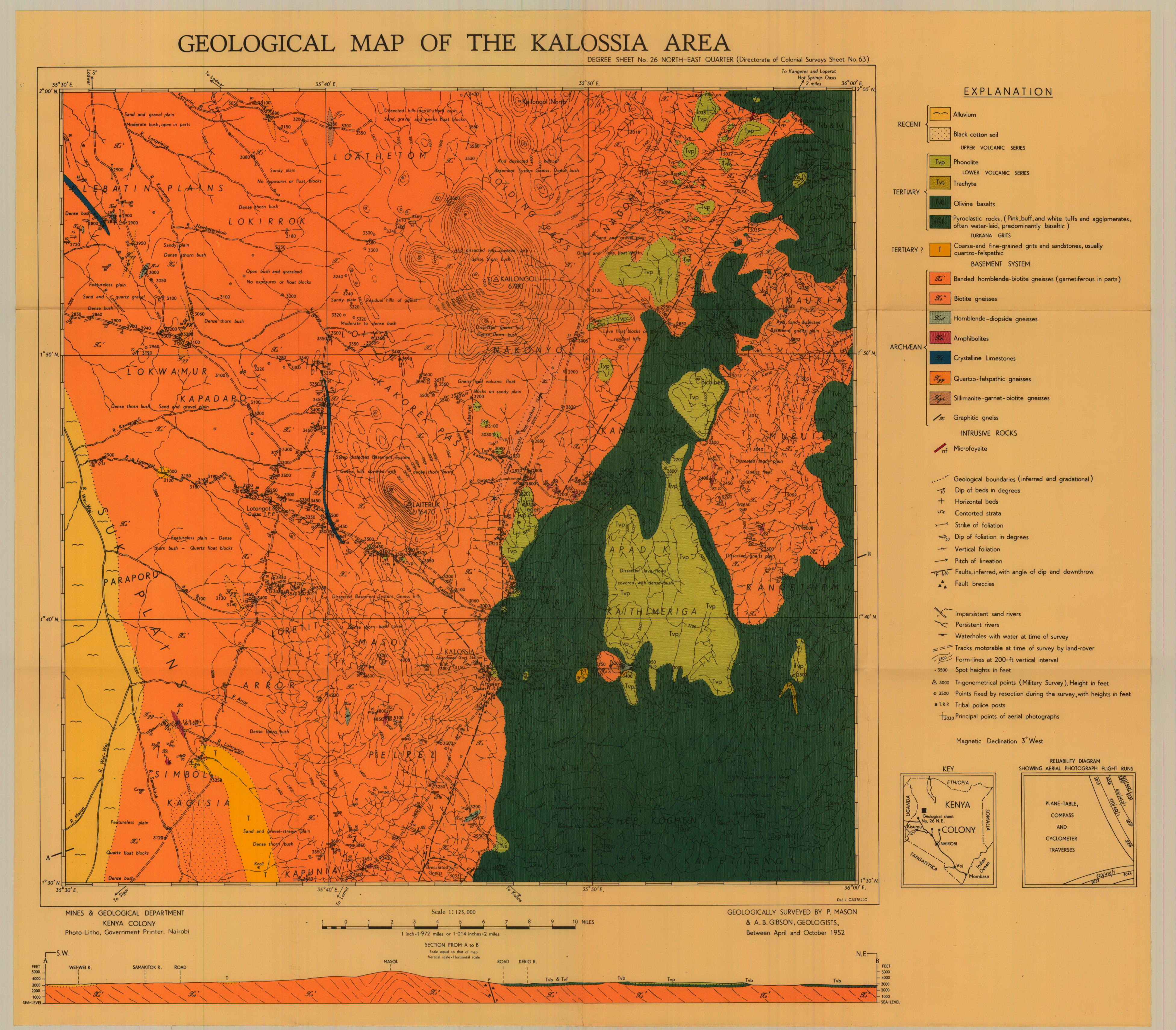
Geological map of the Kalossia area (26 NE)
Scale: 1:125000,
Sheet number/quarter: 26 NE
Year of publication: 1966
Filesize: 7,1 MB
Sheet number/quarter: 26 NE
Year of publication: 1966
Filesize: 7,1 MB
Map coordinates
Top left: 2° 00' N, 35° 30' E
Top right: 2° 00' N, 36° 00' E
Bottom left: 1° 30' N, 36° 00' E
Bottom right: 1° 30' N, 35° 30' E
Top left: 2° 00' N, 35° 30' E
Top right: 2° 00' N, 36° 00' E
Bottom left: 1° 30' N, 36° 00' E
Bottom right: 1° 30' N, 35° 30' E
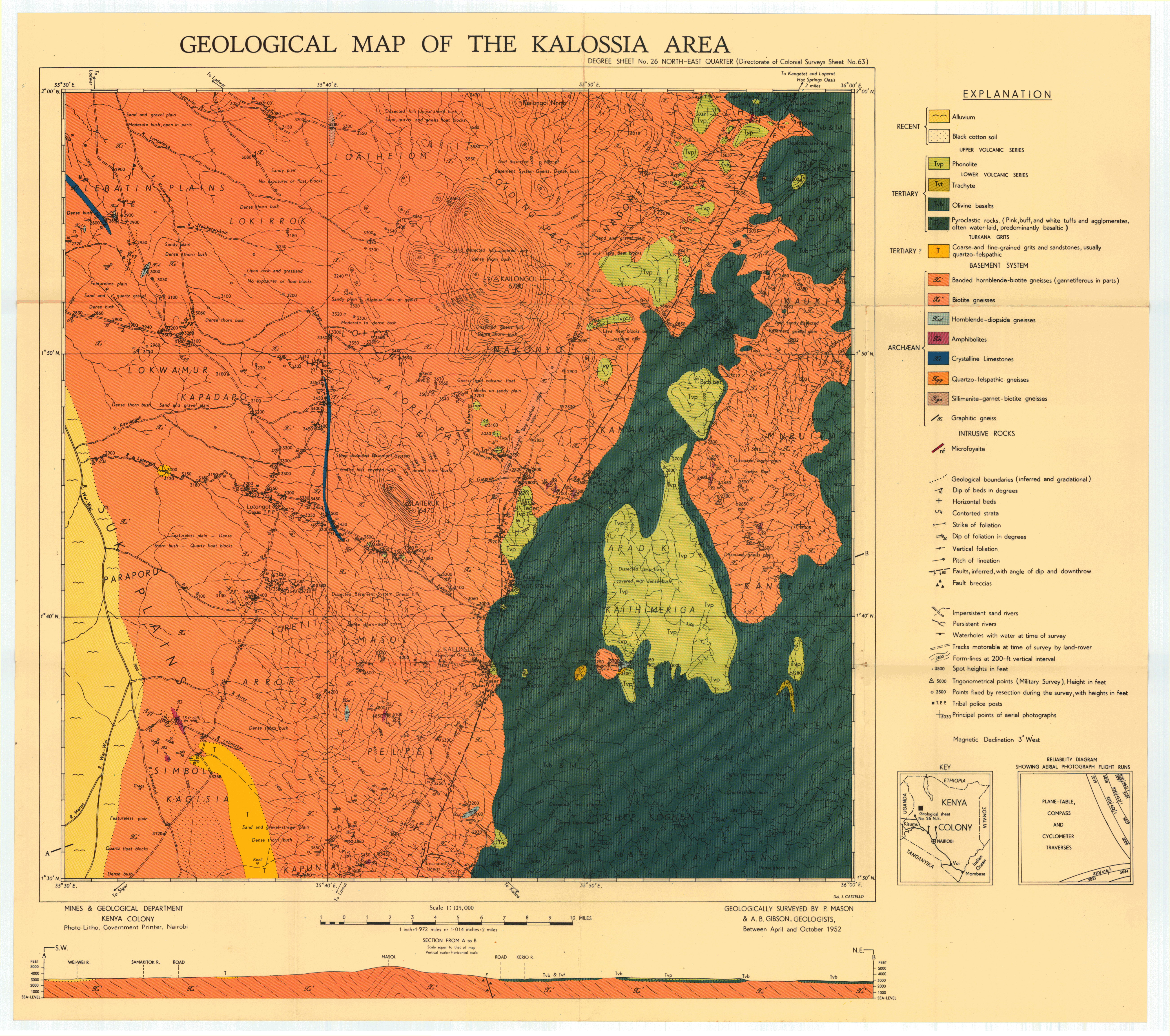
Geological map of the Kalossia area (26 NE)
Scale: 1:125000,
Sheet number/quarter: 26 NE
Year of publication: 1952
Filesize: 2,8 MB
Sheet number/quarter: 26 NE
Year of publication: 1952
Filesize: 2,8 MB
Map coordinates
Top left: 2° 00' N, 35° 30' E
Top right: 2° 00' N, 36° 00' E
Bottom left: 1° 30' N, 35° 30' E
Bottom right: 1° 30' N, 36° 00' E
Top left: 2° 00' N, 35° 30' E
Top right: 2° 00' N, 36° 00' E
Bottom left: 1° 30' N, 35° 30' E
Bottom right: 1° 30' N, 36° 00' E
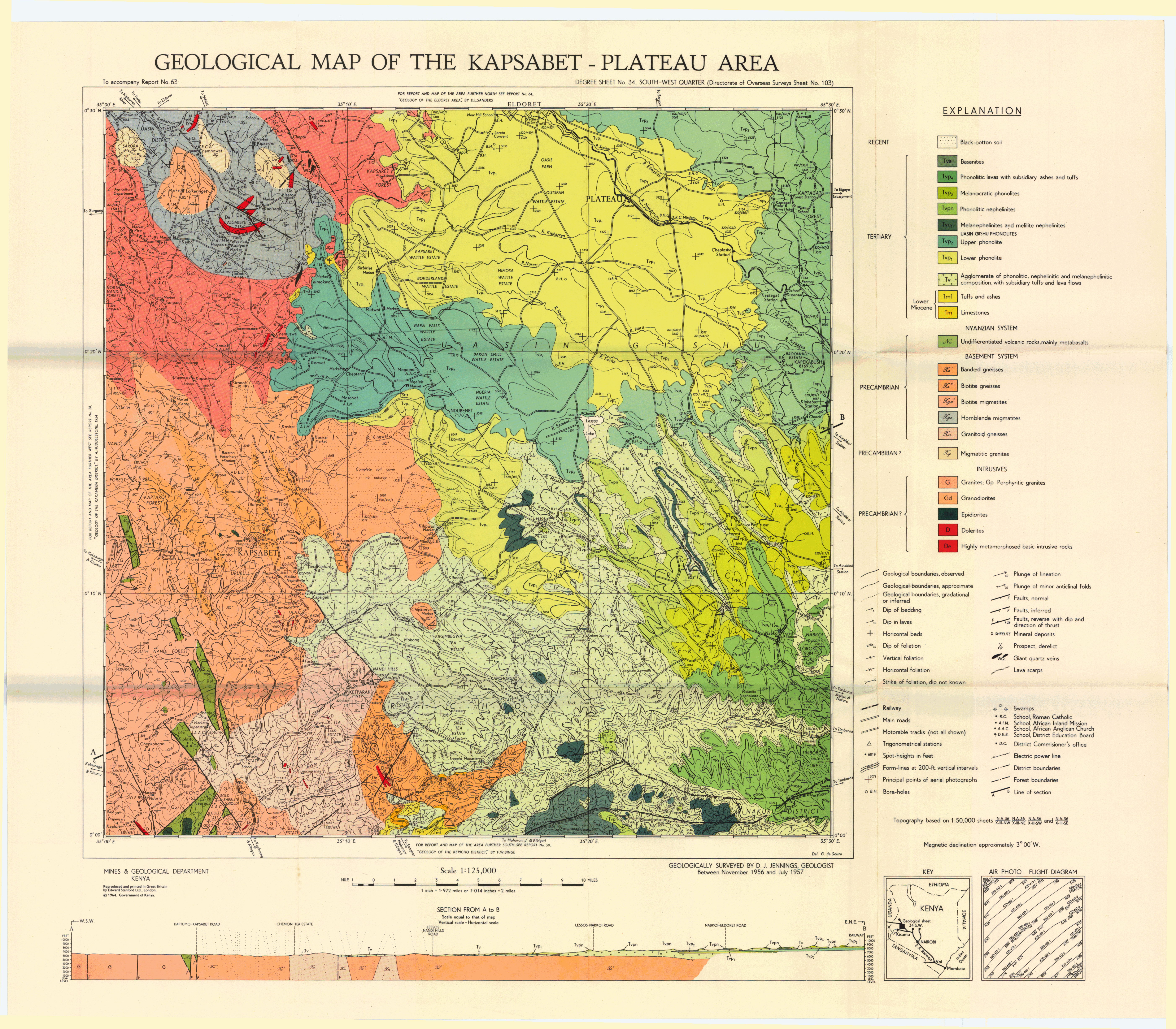
Geological map of the Kapsabet - Plateau area (34 SW)
Scale: 1:125000,
Sheet number/quarter: 34 SW
Year of publication: 1964
Filesize: 2,8 MB
Sheet number/quarter: 34 SW
Year of publication: 1964
Filesize: 2,8 MB
Map coordinates
Top left: 0° 30' N, 35° 00' E
Top right: 0° 30' N, 35° 30' E
Bottom left: 0° 00' N, 35° 30' E
Bottom right: 0° 00' N, 35° 00' E
Top left: 0° 30' N, 35° 00' E
Top right: 0° 30' N, 35° 30' E
Bottom left: 0° 00' N, 35° 30' E
Bottom right: 0° 00' N, 35° 00' E
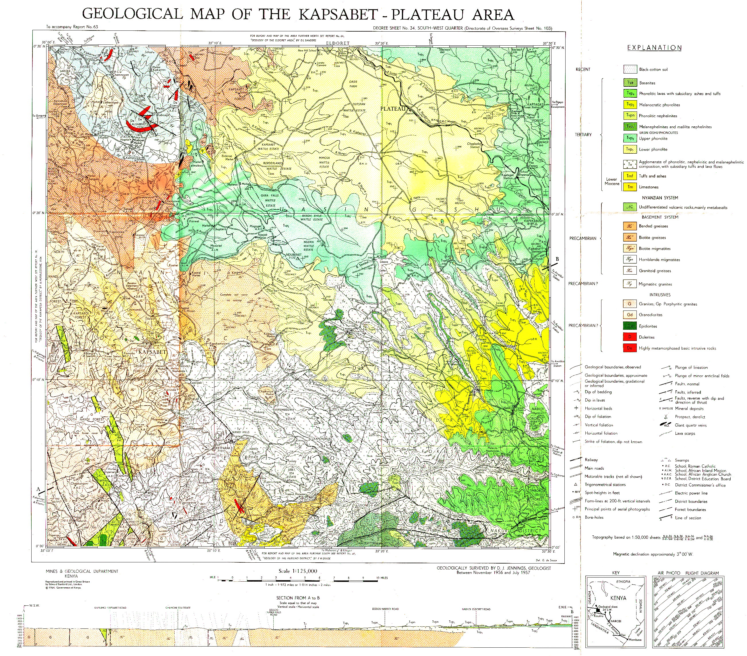
Geological map of the Kapsabet-Plateau area (34 SW)
Scale: 1:125000,
Sheet number/quarter: 34 SW
Year of publication: 1964
Filesize: 6,8 MB
Sheet number/quarter: 34 SW
Year of publication: 1964
Filesize: 6,8 MB
Map coordinates
Top left: 0° 30' N, 35° 00' E
Top right: 0° 30' N, 35° 30' E
Bottom left: 0° 00' N, 35° 30' E
Bottom right: 0° 00' N, 35° 00' E
Top left: 0° 30' N, 35° 00' E
Top right: 0° 30' N, 35° 30' E
Bottom left: 0° 00' N, 35° 30' E
Bottom right: 0° 00' N, 35° 00' E
Geological map of the Karasuk area (18 SW)
Scale: 1:125000,
Sheet number/quarter: 18 SW
Year of publication: Between 1957 and 1958
Filesize: 8,9 MB
Sheet number/quarter: 18 SW
Year of publication: Between 1957 and 1958
Filesize: 8,9 MB
Map coordinates
Top left: 2° 30' N, 34° 53' E
Top right: 2° 30' N, 35° 30' E
Bottom left: 2° 00' N, 35° 30' E
Bottom right: 2° 00' N, 34° 53' E
Top left: 2° 30' N, 34° 53' E
Top right: 2° 30' N, 35° 30' E
Bottom left: 2° 00' N, 35° 30' E
Bottom right: 2° 00' N, 34° 53' E

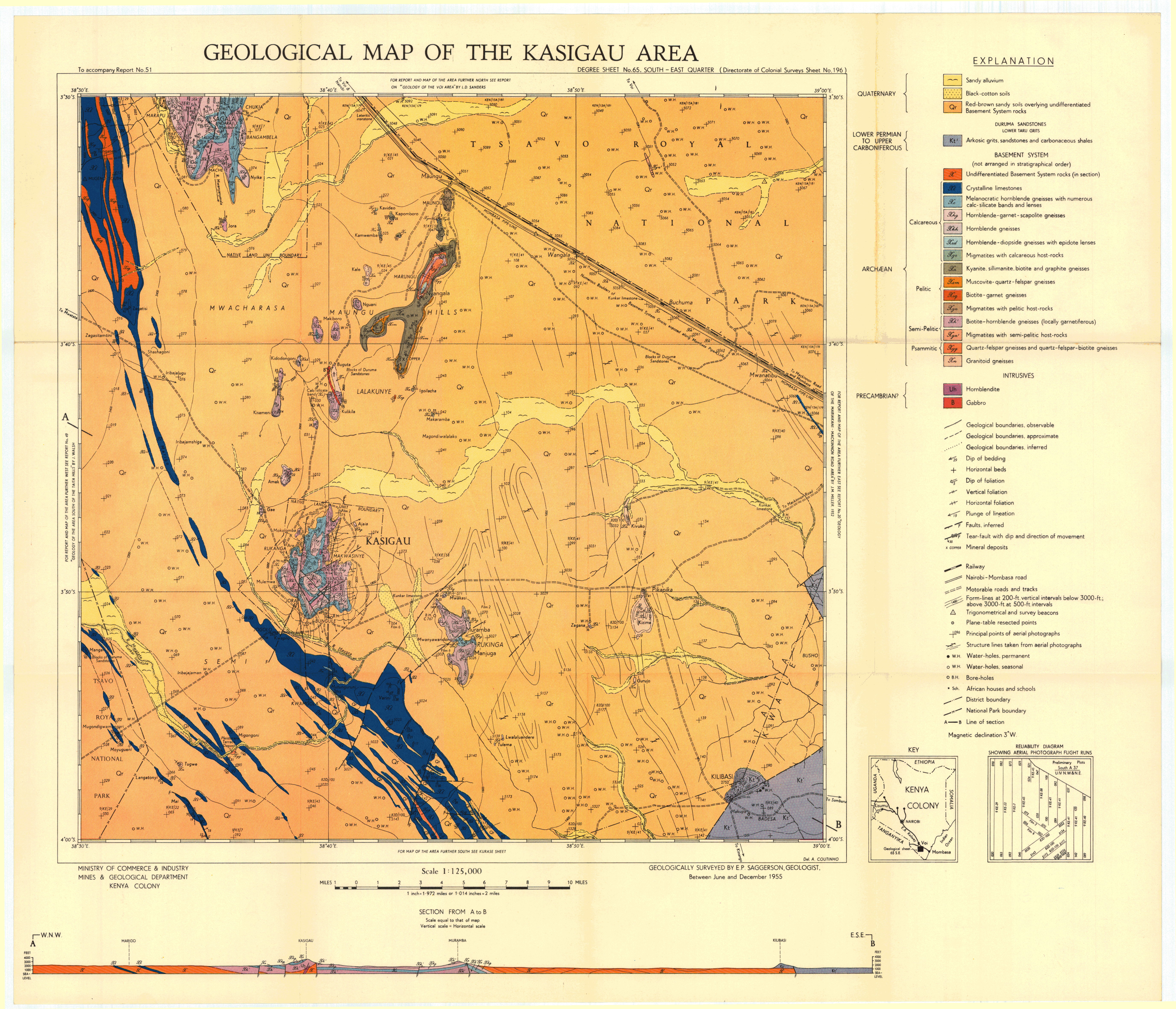
Geological map of the Kasigau area (65 SE)
Scale: 1:125000,
Sheet number/quarter: 65 SE
Year of publication: 1955
Filesize: 8 MB
Sheet number/quarter: 65 SE
Year of publication: 1955
Filesize: 8 MB
Map coordinates
Top left: 3° 30' S, 38° 30' S
Top right: 3° 30' S, 39° 00' E
Bottom left: 4° 00' S, 39° 00' E
Bottom right: 4° 00' S, 38° 30' E
Top left: 3° 30' S, 38° 30' S
Top right: 3° 30' S, 39° 00' E
Bottom left: 4° 00' S, 39° 00' E
Bottom right: 4° 00' S, 38° 30' E
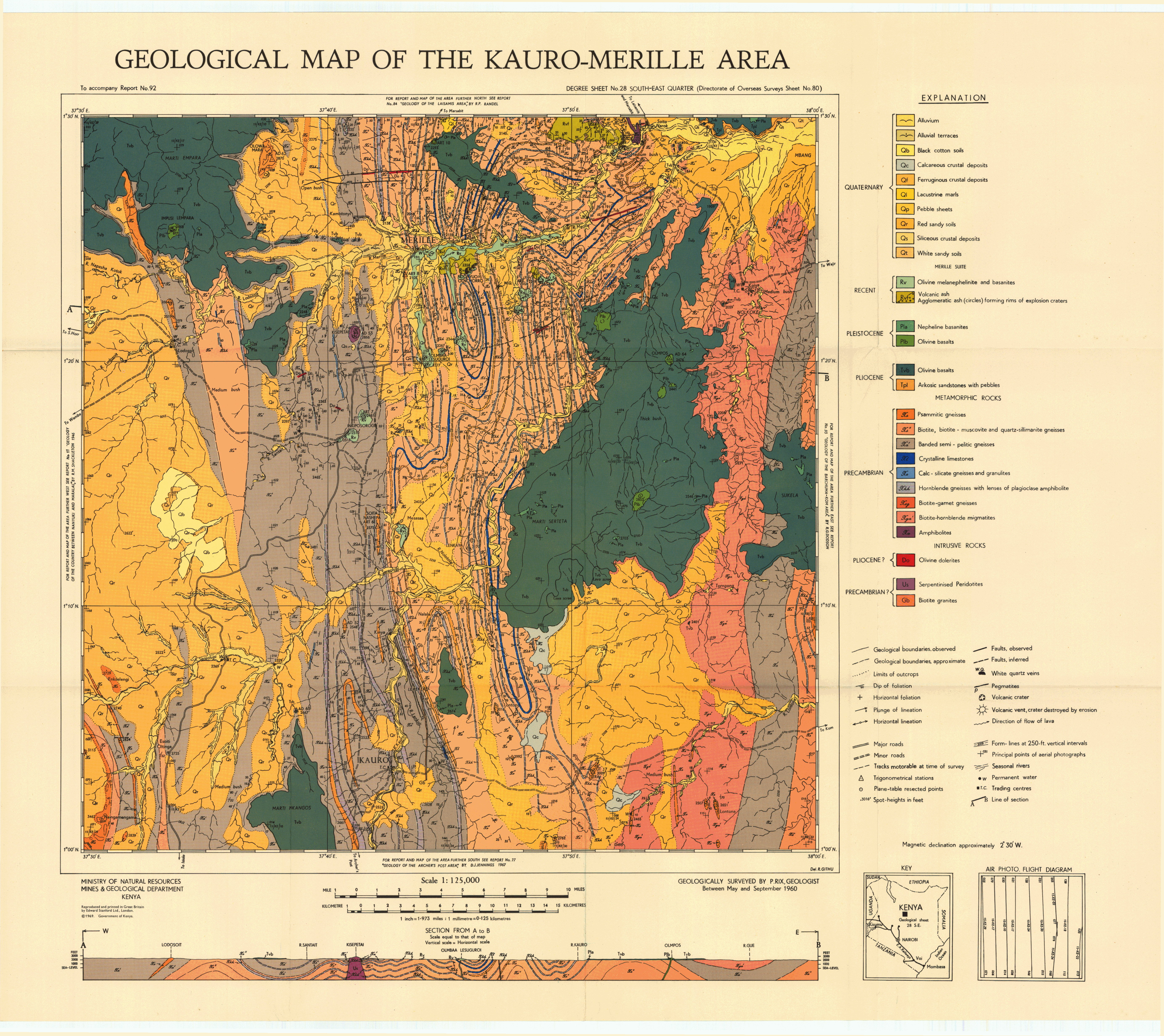
Geological map of the Kauro-Merille area (28 SE)
Scale: 1:125000,
Sheet number/quarter: 28 SE
Year of publication: 1969
Filesize: 6,7 MB
Sheet number/quarter: 28 SE
Year of publication: 1969
Filesize: 6,7 MB
Map coordinates
Top left: 1° 30' N, 37° 30' E
Top right: 1° 30' N, 38° 00' E
Bottom left: 1° 00' N, 38° 00' E
Bottom right: 1° 00' N, 37° 30' E
Top left: 1° 30' N, 37° 30' E
Top right: 1° 30' N, 38° 00' E
Bottom left: 1° 00' N, 38° 00' E
Bottom right: 1° 00' N, 37° 30' E

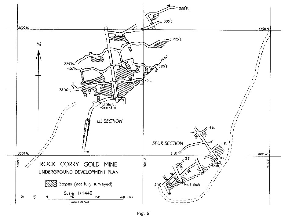
Kericho - Assay plan, part of spur section, Rock corry gold -mine
Year of publication: N/A
Filesize: 0,1 MB
Filesize: 0,1 MB

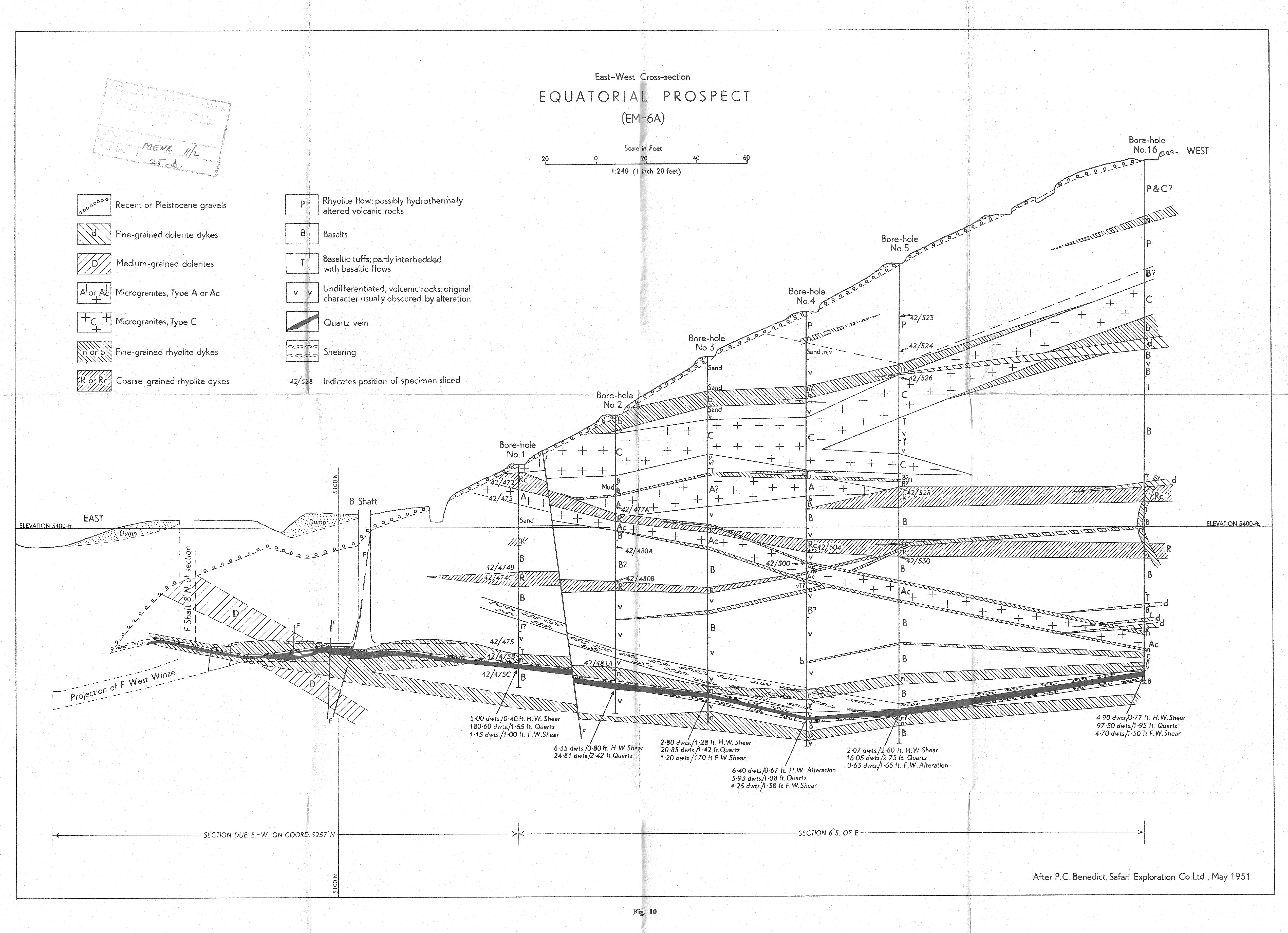
Kericho - East-West Cross -section, Equitorial prospect (EM-6A)
Year of publication: N/A
Filesize: 2,6 MB
Filesize: 2,6 MB
Kericho - Geological plan,part of lil section, rock corry gold-mine
Year of publication: N/A
Filesize: 0,2 MB
Filesize: 0,2 MB

Kericho - North -South cross section ,equitorial prospect (EM-12A)
Year of publication: N/A
Filesize: 1 MB
Filesize: 1 MB

Kericho - Surface plan including contours on the shear-zone & fault, & records of boreholes, equitorial & rock corry gold mines
Year of publication: N/A
Filesize: 0,4 MB
Filesize: 0,4 MB

Kericho - Transverse sections,Rock corry gold mine, the sections are drawn in north-south planes
Year of publication: N/A
Filesize: 0,1 MB
Filesize: 0,1 MB
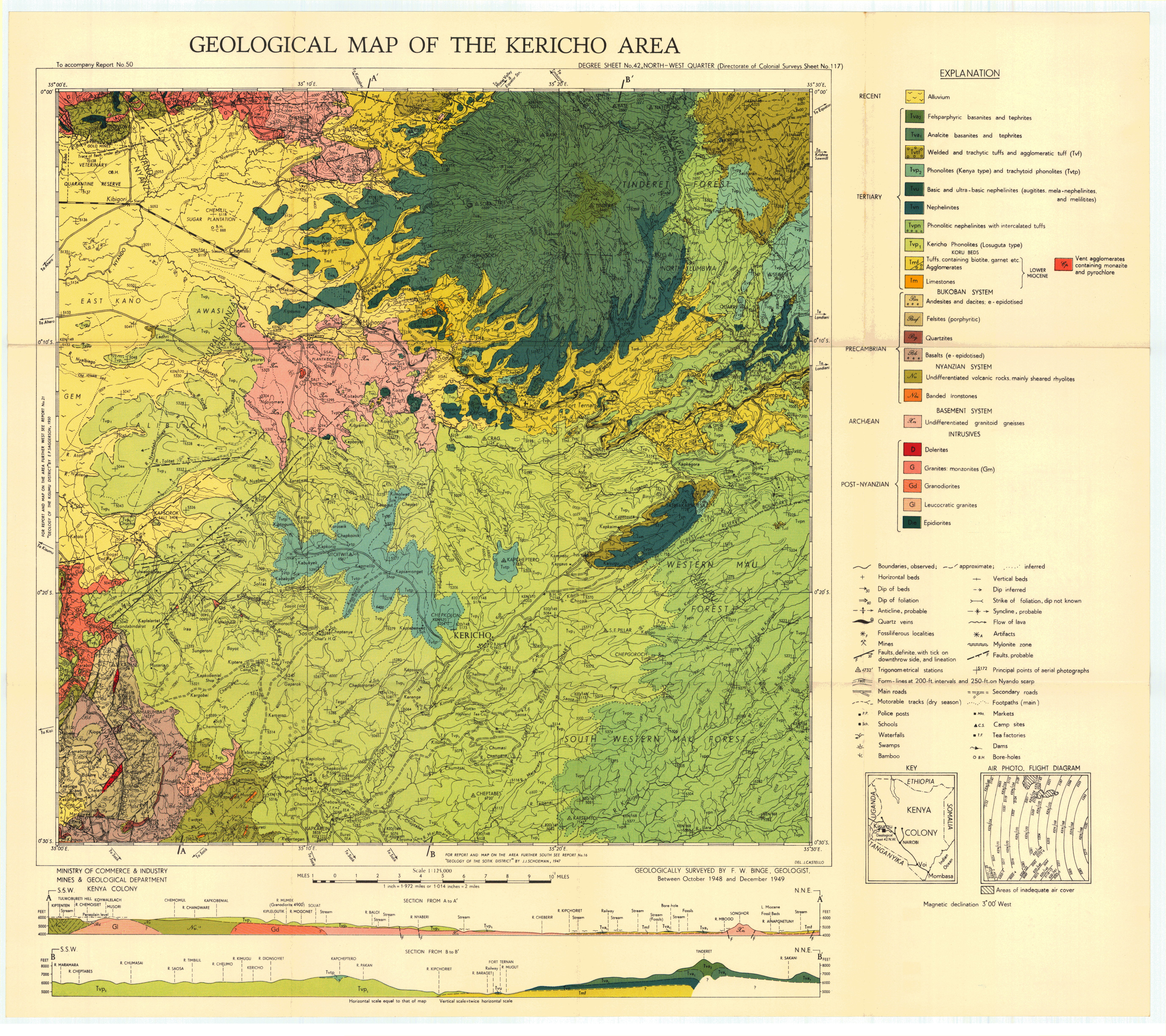
Geological map of the Kericho area (42 NW)
Scale: 1:125000,
Sheet number/quarter: 42 NW
Year of publication: Between 1948 and 1949
Filesize: 8,3 MB
Sheet number/quarter: 42 NW
Year of publication: Between 1948 and 1949
Filesize: 8,3 MB
Map coordinates
Top left: 0° 00' S, 35° 00' E
Top right: 0° 30' S, 35° 30' E
Bottom left: 0° 30' S, 35° 30' E
Bottom right: 0° 30' S, 35° 00' E
Top left: 0° 00' S, 35° 00' E
Top right: 0° 30' S, 35° 30' E
Bottom left: 0° 30' S, 35° 30' E
Bottom right: 0° 30' S, 35° 00' E
Geological map of the Kericho area (43 NW)
Scale: 1:125000,
Sheet number/quarter: 43 NW
Year of publication: Between 1948 and 1949
Filesize: 44,2 MB
Sheet number/quarter: 43 NW
Year of publication: Between 1948 and 1949
Filesize: 44,2 MB
Map coordinates
Top left: 0° 00' S, 35° 00' E
Top right: 0° 00' S, 35° 30' E
Bottom left: 0° 30' S, 35° 30' E
Bottom right: 0° 30' S, 35° 00' E
Top left: 0° 00' S, 35° 00' E
Top right: 0° 00' S, 35° 30' E
Bottom left: 0° 30' S, 35° 30' E
Bottom right: 0° 30' S, 35° 00' E
Geological map of the Kericho area (42 NW)
Scale: 1:125000,
Sheet number/quarter: 42 NW
Year of publication: 1947
Filesize: 3,1 MB
Sheet number/quarter: 42 NW
Year of publication: 1947
Filesize: 3,1 MB
Map coordinates
Top left: 0° 00' N, 35° 00' E
Top right: 0° 00' N, 35° 30' E
Bottom left: 0° 30' S, 35° 30' E
Bottom right: 0° 30' S, 35° 00' E
Top left: 0° 00' N, 35° 00' E
Top right: 0° 00' N, 35° 30' E
Bottom left: 0° 30' S, 35° 30' E
Bottom right: 0° 30' S, 35° 00' E

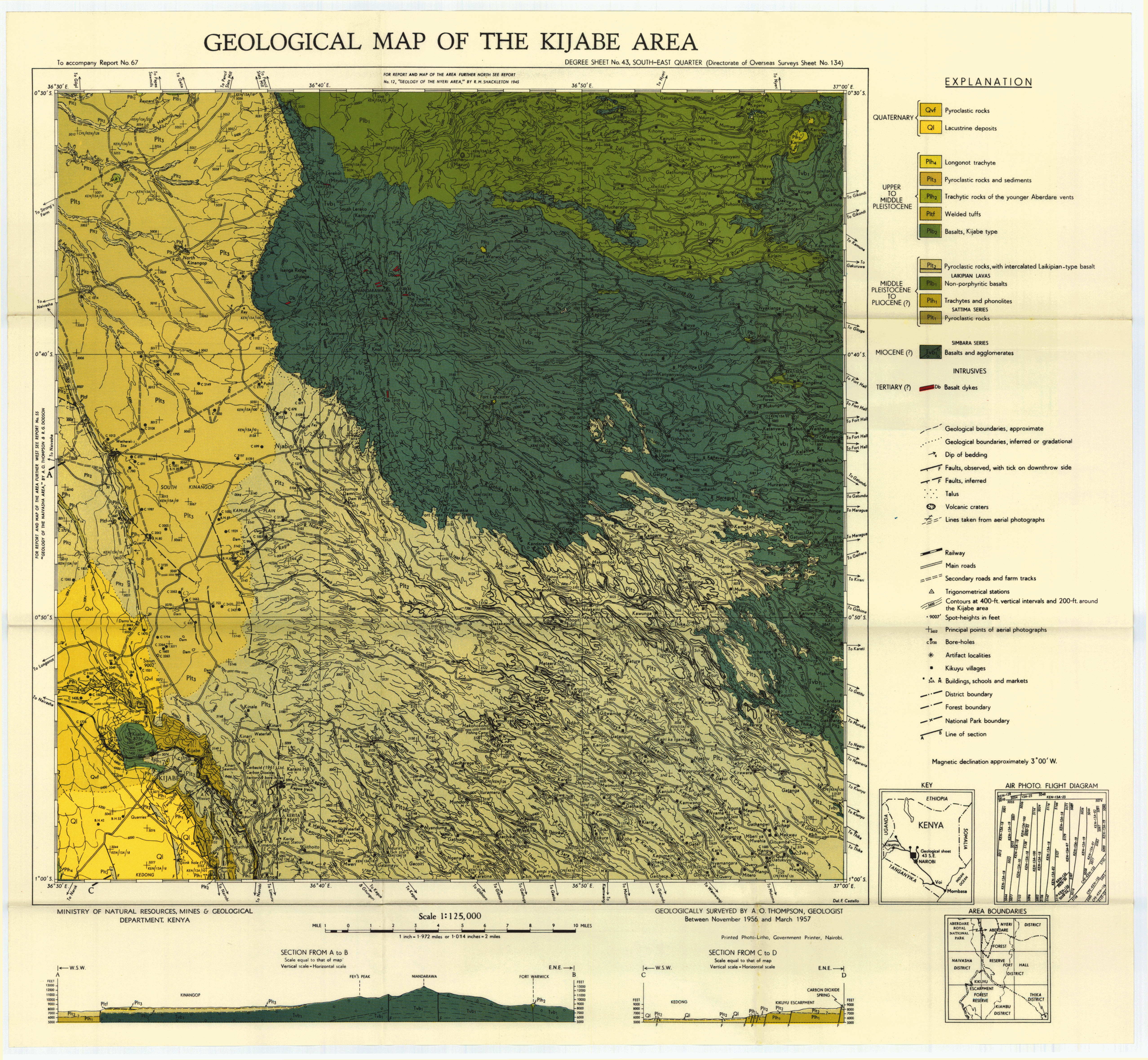
Geological map of the Kijabe area (43 SE)
Scale: 1:125000,
Sheet number/quarter: 43 SE
Year of publication: Between 1956 and 1957
Filesize: 7,8 MB
Sheet number/quarter: 43 SE
Year of publication: Between 1956 and 1957
Filesize: 7,8 MB
Map coordinates
Top left: 0° 30' S, 36° 30' E
Top right: 0° 30' S, 37° 00' E
Bottom left: 1° 00' S, 36° 30' E
Bottom right: 1° 00' S, 37° 00' E
Top left: 0° 30' S, 36° 30' E
Top right: 0° 30' S, 37° 00' E
Bottom left: 1° 00' S, 36° 30' E
Bottom right: 1° 00' S, 37° 00' E
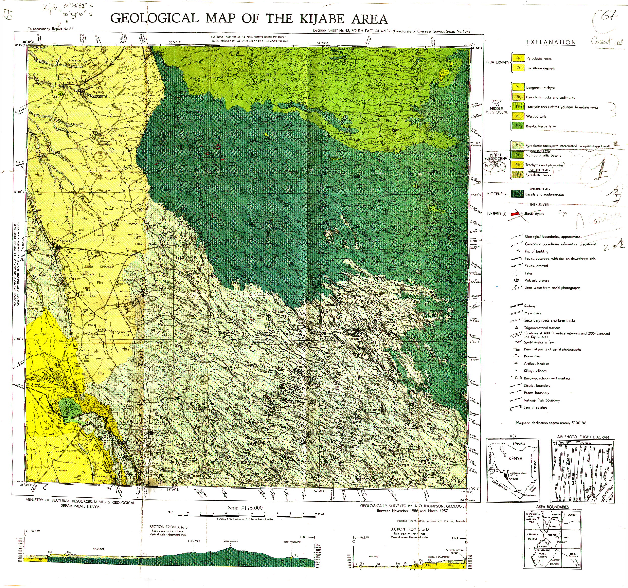
Geological map of the Kijabe area (43 SE)
Scale: 1:125000,
Sheet number/quarter: 43 SE
Year of publication: n/a
Filesize: 2,6 MB
Sheet number/quarter: 43 SE
Year of publication: n/a
Filesize: 2,6 MB
Map coordinates
Top left: 0° 30' S, 36° 30' E
Top right: 0° 30' S, 37° 00' E
Bottom left: 1° 00' S, 37° 00' E
Bottom right: 1° 00' S, 35° 00' E
Top left: 0° 30' S, 36° 30' E
Top right: 0° 30' S, 37° 00' E
Bottom left: 1° 00' S, 37° 00' E
Bottom right: 1° 00' S, 35° 00' E
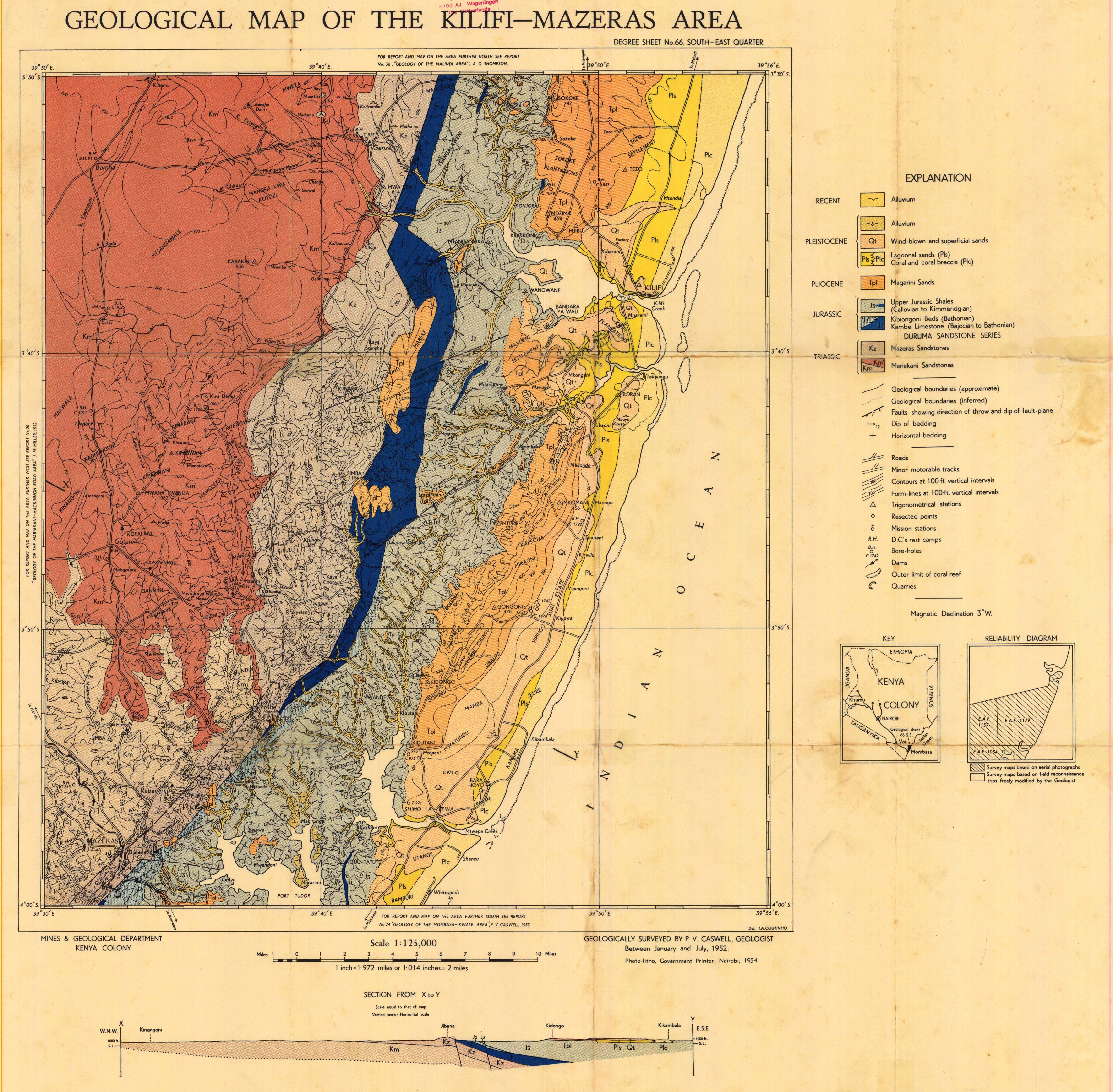
Geological map of the Kilifi-Mazeras area (66 SE)
Scale: 1:125000,
Sheet number/quarter: 66 SE
Year of publication: 1954
Filesize: 5,7 MB
Sheet number/quarter: 66 SE
Year of publication: 1954
Filesize: 5,7 MB
Map coordinates
Top left: 3° 30' S, 39° 30' E
Top right: 3° 30' S, 39° 56' E
Bottom left: 4° 00' S, 39° 56' E
Bottom right: 4° 00' S, 39° 30' E
Top left: 3° 30' S, 39° 30' E
Top right: 3° 30' S, 39° 56' E
Bottom left: 4° 00' S, 39° 56' E
Bottom right: 4° 00' S, 39° 30' E

Geological map of the Kilifi-Mazeras area (66 SE)
Scale: 1:125000,
Sheet number/quarter: 66 SE
Year of publication: 1954
Filesize: 2,7 MB
Sheet number/quarter: 66 SE
Year of publication: 1954
Filesize: 2,7 MB
Map coordinates
Top left: 3° 30' S, 39° 30' E
Top right: 3° 30' S, 39° 56' E
Bottom left: 4° 00' S, 39° 56' E
Bottom right: 4° 00' S, 39° 30' E
Top left: 3° 30' S, 39° 30' E
Top right: 3° 30' S, 39° 56' E
Bottom left: 4° 00' S, 39° 56' E
Bottom right: 4° 00' S, 39° 30' E
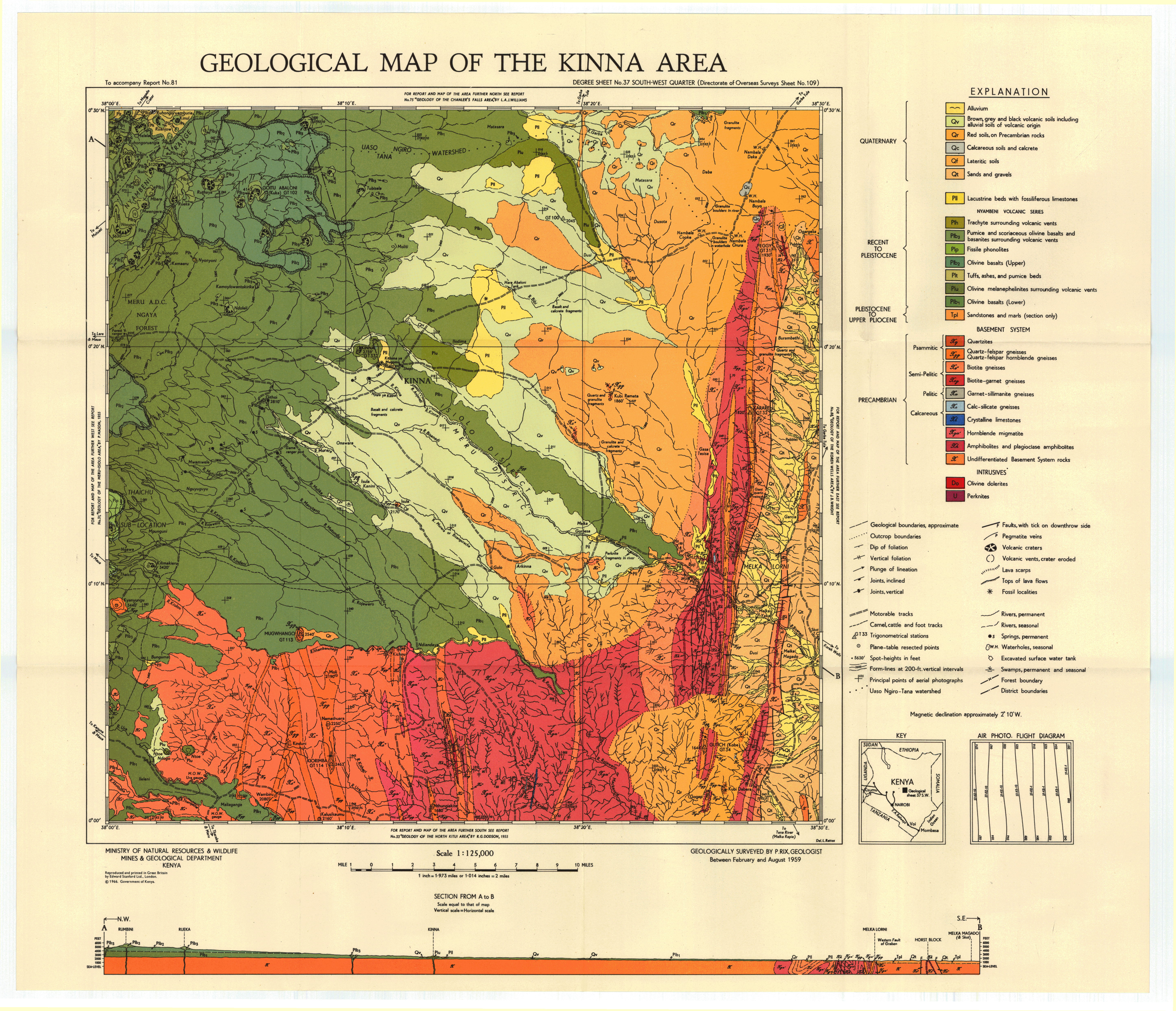
Geological map of the Kinna area (37 SW)
Scale: 1:125000,
Sheet number/quarter: 37 SW
Year of publication: 1966
Filesize: 7,1 MB
Sheet number/quarter: 37 SW
Year of publication: 1966
Filesize: 7,1 MB
Map coordinates
Top left: 0° 30' N, 38° 00' E
Top right: 0° 30' N, 38° 30' E
Bottom left: 0° 00' N, 38° 30' E
Bottom right: 0° 00' N, 38° 30' E
Top left: 0° 30' N, 38° 00' E
Top right: 0° 30' N, 38° 30' E
Bottom left: 0° 00' N, 38° 30' E
Bottom right: 0° 00' N, 38° 30' E
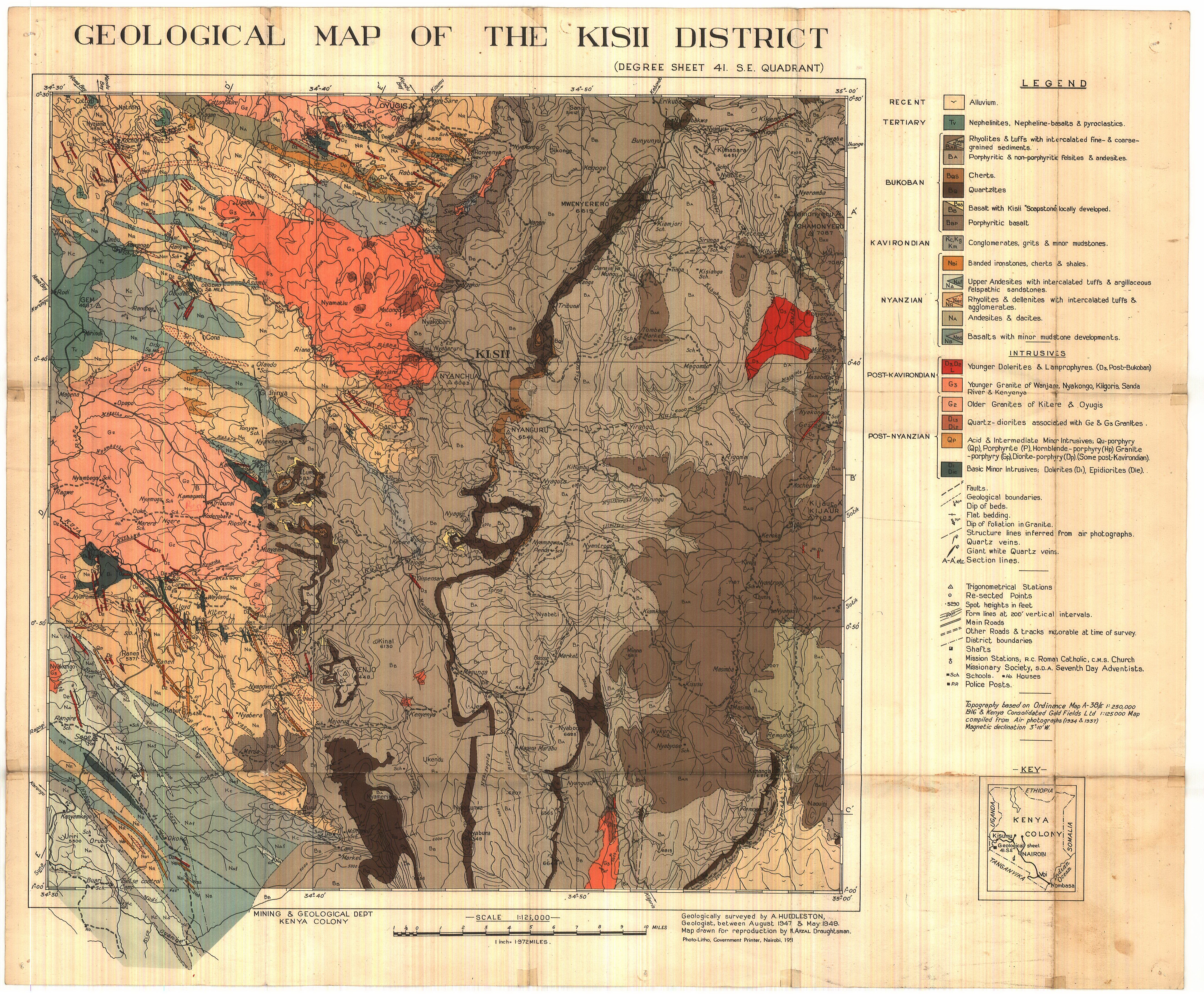
Geological map of the Kisii District (41 SE)
Scale: 1:125000,
Sheet number/quarter: 41 SE
Year of publication: 1951
Filesize: 5,8 MB
Sheet number/quarter: 41 SE
Year of publication: 1951
Filesize: 5,8 MB
Map coordinates
Top left: 0° 30' S, 34° 30' E
Top right: 0° 30' S, 35° 00' E
Bottom left: 1° 00' S, 35° 00' E
Bottom right: 1° 00' S, 34° 30' E
Top left: 0° 30' S, 34° 30' E
Top right: 0° 30' S, 35° 00' E
Bottom left: 1° 00' S, 35° 00' E
Bottom right: 1° 00' S, 34° 30' E
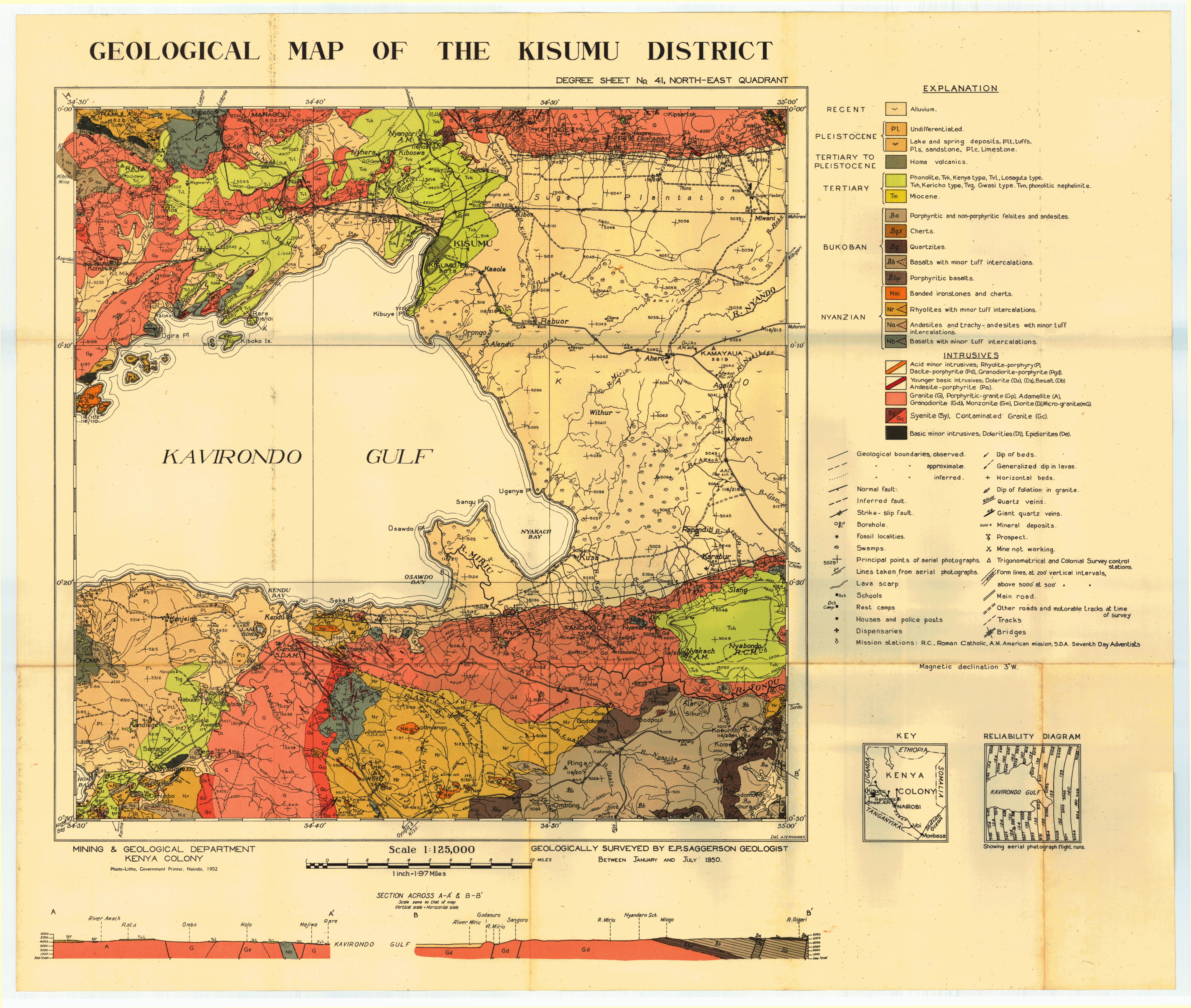
Geological map of the Kisumu District (41 NE)
Scale: 1:125000,
Sheet number/quarter: 41 NE
Year of publication: 1952
Filesize: 6,4 MB
Sheet number/quarter: 41 NE
Year of publication: 1952
Filesize: 6,4 MB
Map coordinates
Top left: 0° 00' S, 34° 30' E
Top right: 0° 00' S, 35° 00' E
Bottom left: 0° 30' S, 35° 00' E
Bottom right: 0° 30' S, 34° 30' E
Top left: 0° 00' S, 34° 30' E
Top right: 0° 00' S, 35° 00' E
Bottom left: 0° 30' S, 35° 00' E
Bottom right: 0° 30' S, 34° 30' E
Geological map of the area North West of Kitale (25 SE)
Scale: 1:125000,
Sheet number/quarter: 25 SE
Year of publication: 1951
Filesize: 3,8 MB
Sheet number/quarter: 25 SE
Year of publication: 1951
Filesize: 3,8 MB
Map coordinates
Top left: 1° 30' N, 34° 30' E
Top right: 1° 30' N, 35° 00' E
Bottom left: 1° 00' N, 35° 00' E
Bottom right: 1° 00' N, 34° 30' E
Top left: 1° 30' N, 34° 30' E
Top right: 1° 30' N, 35° 00' E
Bottom left: 1° 00' N, 35° 00' E
Bottom right: 1° 00' N, 34° 30' E
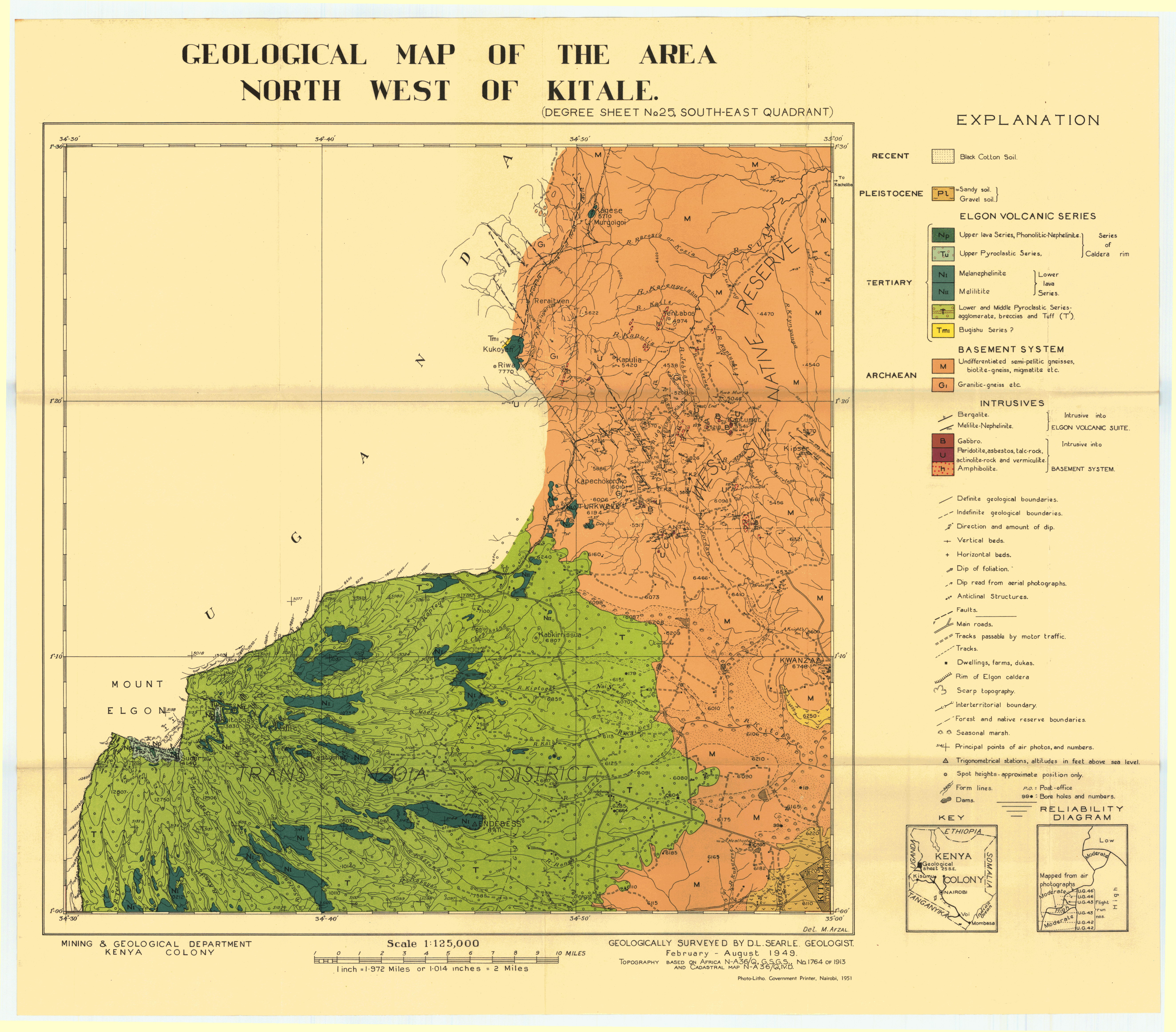
North West of Kitale (25 SE)
Scale: 1:125000,
Sheet number/quarter: 25 SE
Year of publication: 1951
Filesize: 4,1 MB
Sheet number/quarter: 25 SE
Year of publication: 1951
Filesize: 4,1 MB
Map coordinates
Top left: 1° 30' N, 34° 30' E
Top right: 1° 30' N, 35° 00' E
Bottom left: 1° 00' N, 34° 30' E
Bottom right: 1° 00' N, 35° 00' E
Top left: 1° 30' N, 34° 30' E
Top right: 1° 30' N, 35° 00' E
Bottom left: 1° 00' N, 34° 30' E
Bottom right: 1° 00' N, 35° 00' E
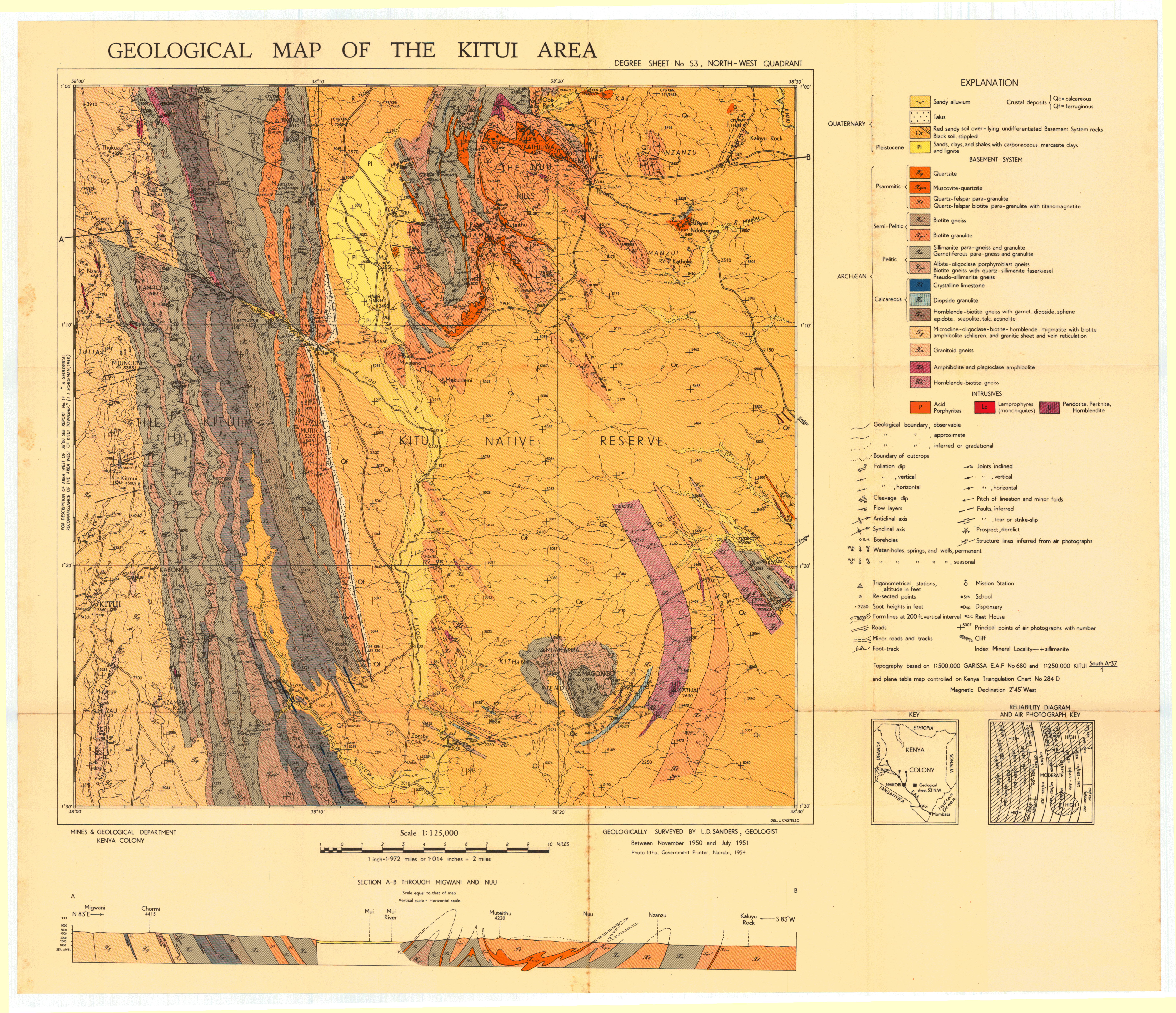
Geological map of the Kitui area (53 NW)
Scale: 1:125000,
Sheet number/quarter: 53 NW
Year of publication: 1954
Filesize: 7,8 MB
Sheet number/quarter: 53 NW
Year of publication: 1954
Filesize: 7,8 MB
Map coordinates
Top left: 1° 00' S, 38° 00' E
Top right: 1° 00' S, 38° 30' E
Bottom left: 1° 30' S, 38° 00' E
Bottom right: 1° 30' S, 38° 30' E
Top left: 1° 00' S, 38° 00' E
Top right: 1° 00' S, 38° 30' E
Bottom left: 1° 30' S, 38° 00' E
Bottom right: 1° 30' S, 38° 30' E
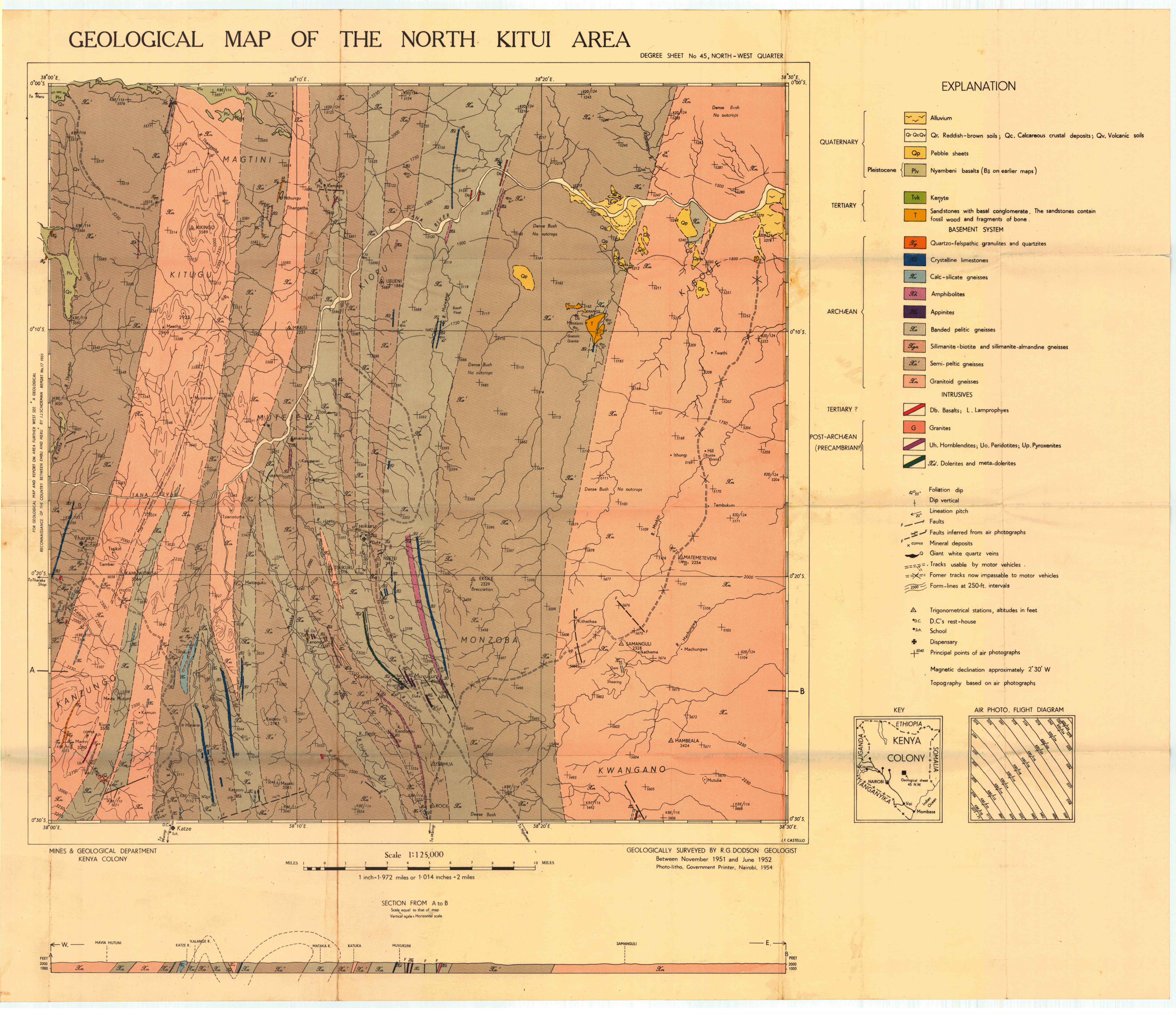
Geological map of the North Kitui area (45 NW)
Scale: 1:125000,
Sheet number/quarter: 45 NW
Year of publication: 1954
Filesize: 7,2 MB
Sheet number/quarter: 45 NW
Year of publication: 1954
Filesize: 7,2 MB
Map coordinates
Top left: 0° 00' S, 38° 00' E
Top right: 0° 00' S, 38° 30' E
Bottom left: 0° 30' S, 38° 30' E
Bottom right: 0° 30' S, 38° 00' E
Top left: 0° 00' S, 38° 00' E
Top right: 0° 00' S, 38° 30' E
Bottom left: 0° 30' S, 38° 30' E
Bottom right: 0° 30' S, 38° 00' E
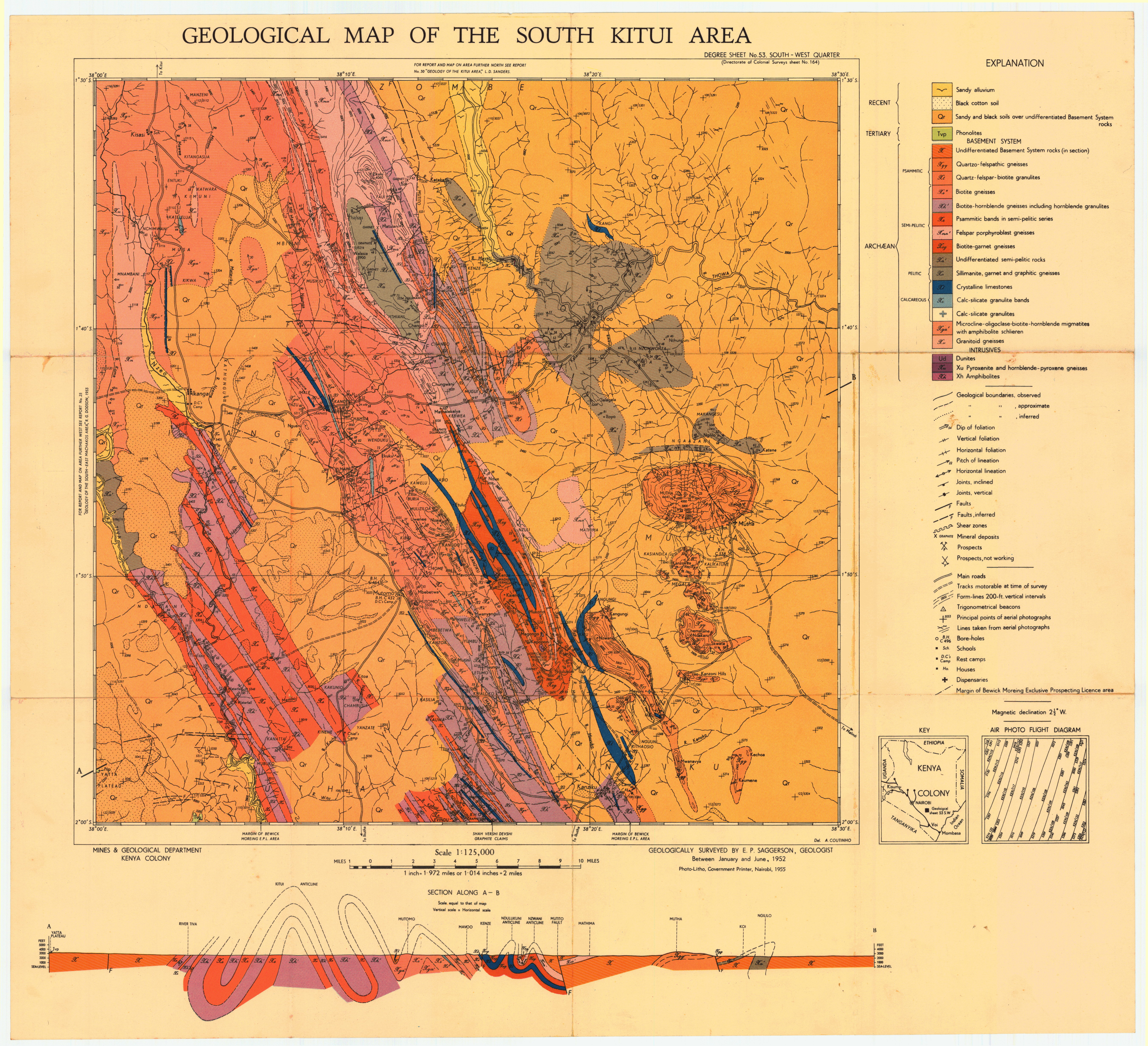
Geological map of the South Kitui area (53 SW)
Scale: 1:125000,
Sheet number/quarter: 53 SW
Year of publication: 1955
Filesize: 8,2 MB
Sheet number/quarter: 53 SW
Year of publication: 1955
Filesize: 8,2 MB
Map coordinates
Top left: 1° 30' S, 38° 00' E
Top right: 1° 30' S, 38° 30' E
Bottom left: 2° 00' S, 38° 30' E
Bottom right: 2° 00' S, 38° 00' E
Top left: 1° 30' S, 38° 00' E
Top right: 1° 30' S, 38° 30' E
Bottom left: 2° 00' S, 38° 30' E
Bottom right: 2° 00' S, 38° 00' E
Geological map of Kora -Kalimangilu Area (45 NE)
Scale: 1:125000,
Sheet number/quarter: 45 NE
Year of publication: 1972
Filesize: 7,2 MB
Sheet number/quarter: 45 NE
Year of publication: 1972
Filesize: 7,2 MB
Map coordinates
Top left: 0° 00' S, 38° 30' E
Top right: 0° 00' S, 39° 00' E
Bottom left: 0° 30' S, 39° 00' E
Bottom right: 0° 00' S, 39° 00' E
Top left: 0° 00' S, 38° 30' E
Top right: 0° 00' S, 39° 00' E
Bottom left: 0° 30' S, 39° 00' E
Bottom right: 0° 00' S, 39° 00' E

Geological map of Kora Wells Area (37 SE)
Scale: 1:125000,
Sheet number/quarter: 37 SE
Year of publication: 1967
Filesize: 6,8 MB
Sheet number/quarter: 37 SE
Year of publication: 1967
Filesize: 6,8 MB
Map coordinates
Top left: 0° 30' N, 38° 30' E
Top right: 0° 30' N, 39° 00' E
Bottom left: 0° 00' N, 39° 00' E
Bottom right: 0° 00' N, 38° 30' E
Top left: 0° 30' N, 38° 30' E
Top right: 0° 30' N, 39° 00' E
Bottom left: 0° 00' N, 39° 00' E
Bottom right: 0° 00' N, 38° 30' E

Geological map of the Kora Wells area (37 SE)
Scale: 1:125000,
Sheet number/quarter: 37 SE
Year of publication: 1967
Filesize: 2,5 MB
Sheet number/quarter: 37 SE
Year of publication: 1967
Filesize: 2,5 MB
Map coordinates
Top left: 0° 30' N, 38° 30' E
Top right: 0° 30' N, 39° 00' E
Bottom left: 0° 00' N, 39° 00' E
Bottom right: 0° 00' N, 38° 30' E
Top left: 0° 30' N, 38° 30' E
Top right: 0° 30' N, 39° 00' E
Bottom left: 0° 00' N, 39° 00' E
Bottom right: 0° 00' N, 38° 30' E

Geological map of Kurase Area (68 NE)
Scale: 1:125000,
Sheet number/quarter: 68 NE
Year of publication: 1955
Filesize: 7,1 MB
Sheet number/quarter: 68 NE
Year of publication: 1955
Filesize: 7,1 MB
Map coordinates
Top left: 4° 00' S, 38° 30' E
Top right: 4° 00' S, 39° 00' E
Bottom left: N/A
Bottom right: N/A
Top left: 4° 00' S, 38° 30' E
Top right: 4° 00' S, 39° 00' E
Bottom left: N/A
Bottom right: N/A

Geological map of the Laisamis area (28 NE)
Scale: 1:125000,
Sheet number/quarter: 28 NE
Year of publication: 1966
Filesize: 13,7 MB
Sheet number/quarter: 28 NE
Year of publication: 1966
Filesize: 13,7 MB
Map coordinates
Top left: 2° 00' N, 37° 30' E
Top right: 2° 00' N, 38° 00' E
Bottom left: 1° 30' N, 37° 30' E
Bottom right: 1° 30' N, 38° 00' E
Top left: 2° 00' N, 37° 30' E
Top right: 2° 00' N, 38° 00' E
Bottom left: 1° 30' N, 37° 30' E
Bottom right: 1° 30' N, 38° 00' E

Geological map of the Lake Jipe area (64 SE)
Scale: 1:125000,
Sheet number/quarter: 64 SE
Year of publication: 1954
Filesize: 3 MB
Sheet number/quarter: 64 SE
Year of publication: 1954
Filesize: 3 MB
Map coordinates
Top left: N/A
Top right: 3° 30' E, 38° 00' E
Bottom left: 3° 50' S, 38° 00' E
Bottom right: 3° 30' S, 38° 00' E
Top left: N/A
Top right: 3° 30' E, 38° 00' E
Bottom left: 3° 50' S, 38° 00' E
Bottom right: 3° 30' S, 38° 00' E

Geological map of the Lake Jipe area (64 SE)
Scale: 1:125000,
Sheet number/quarter: 64 SE
Year of publication: 1954
Filesize: 0,9 MB
Sheet number/quarter: 64 SE
Year of publication: 1954
Filesize: 0,9 MB
Map coordinates
Top left: N/A
Top right: 3° 30' S, 38° 00' E
Bottom left: 3° 50' S, 38° 00' E
Bottom right: N/A
Top left: N/A
Top right: 3° 30' S, 38° 00' E
Bottom left: 3° 50' S, 38° 00' E
Bottom right: N/A

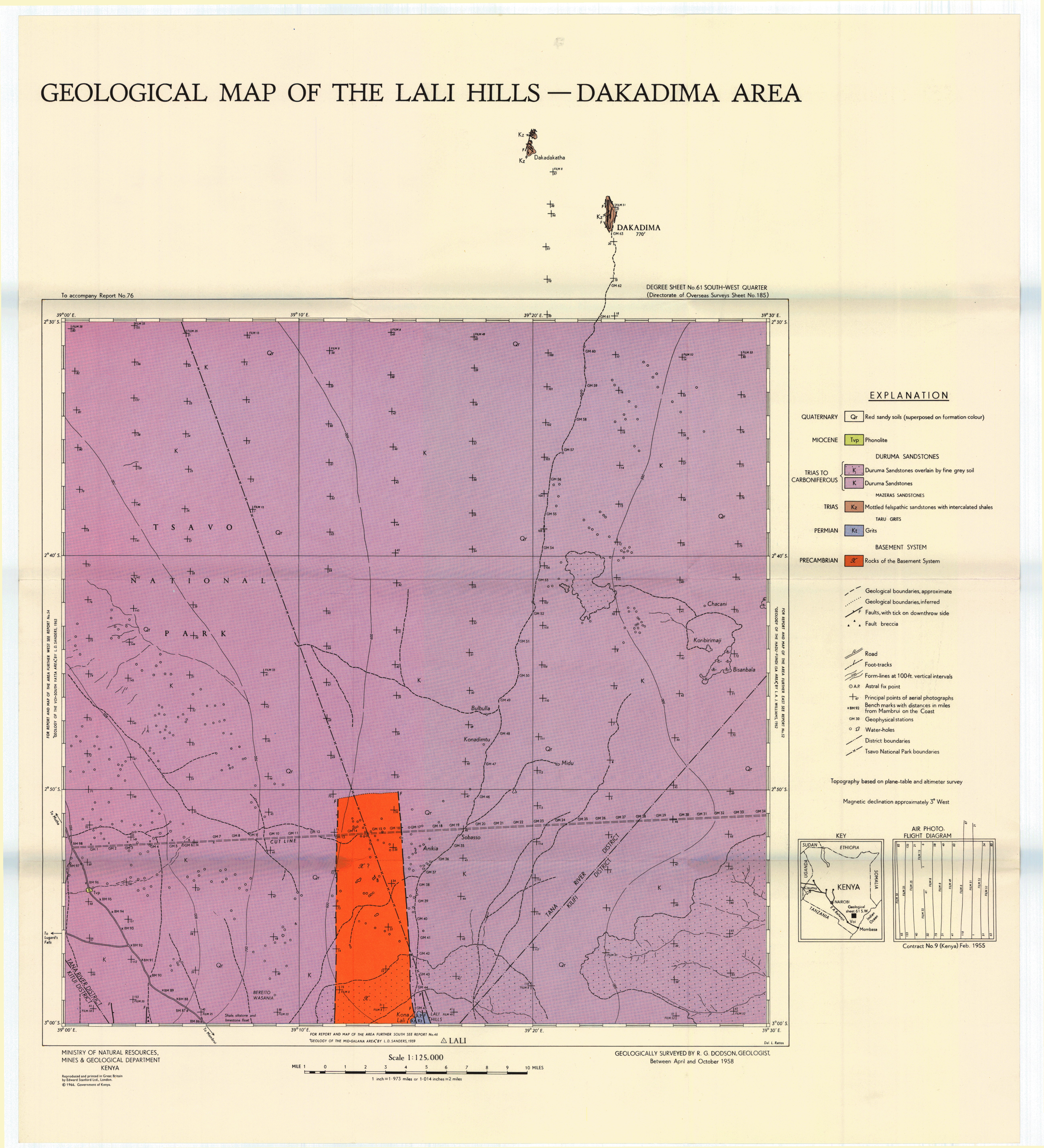
Geological map of the Lali - Dakadima area (61 SW)
Scale: 1:125000,
Sheet number/quarter: 61 SW
Year of publication: 1966
Filesize: 6 MB
Sheet number/quarter: 61 SW
Year of publication: 1966
Filesize: 6 MB
Map coordinates
Top left: 2° 30' S, 39° 00' E
Top right: 2° 30' S, 39° 30' E
Bottom left: 3° 00' S, 39° 30' E
Bottom right: 3° 00' S, 39° 00' E
Top left: 2° 30' S, 39° 00' E
Top right: 2° 30' S, 39° 30' E
Bottom left: 3° 00' S, 39° 30' E
Bottom right: 3° 00' S, 39° 00' E
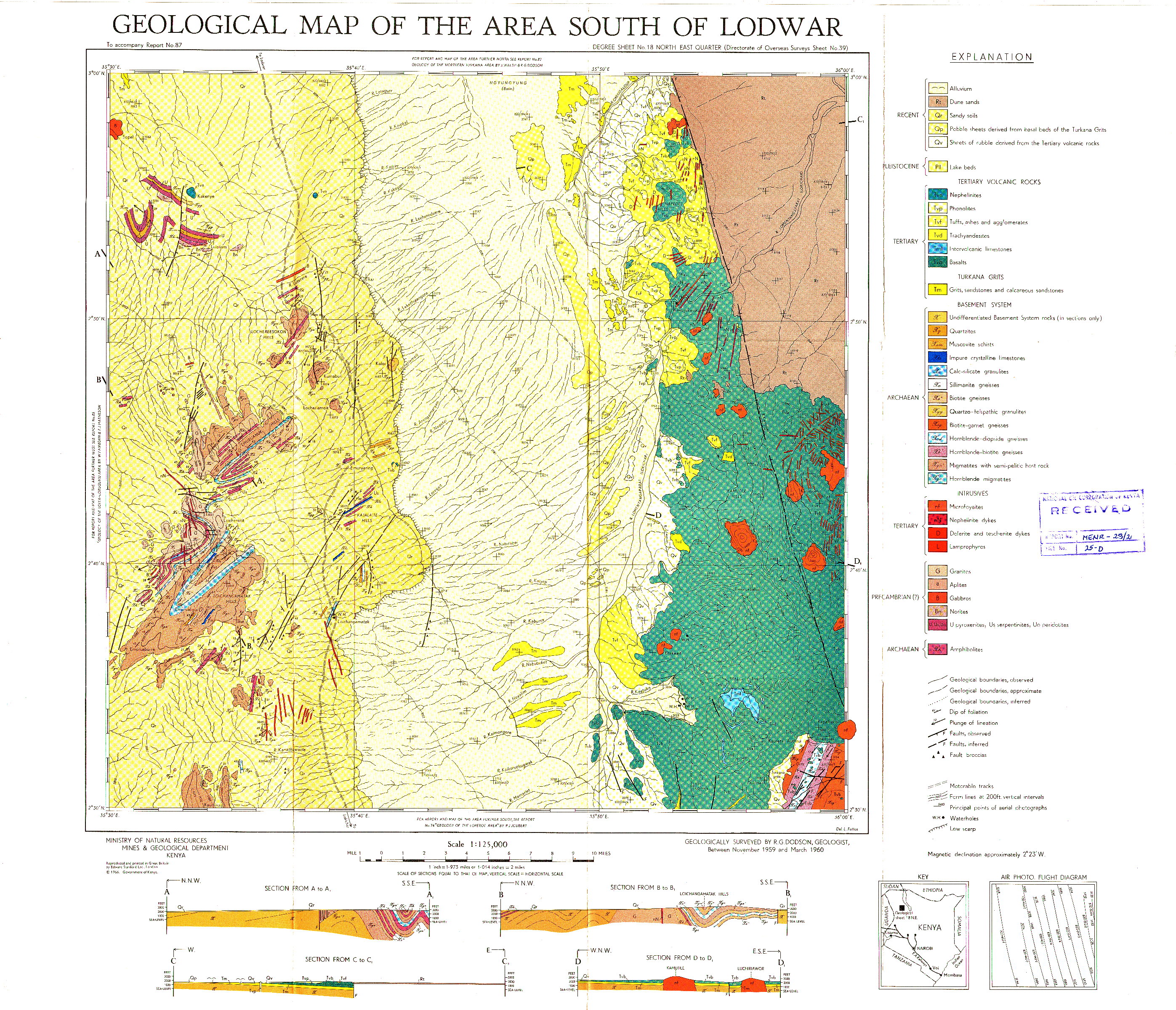
Geological map of the area of South Lodwar (18 NE)
Scale: 1:125000,
Sheet number/quarter: 18 NE
Year of publication: 1966
Filesize: 2,6 MB
Sheet number/quarter: 18 NE
Year of publication: 1966
Filesize: 2,6 MB
Map coordinates
Top left: 3° 00' N, 35° 30' E
Top right: 3° 00' N, 36° 00' E
Bottom left: 2° 30' N, 36° 00' E
Bottom right: 2° 30' N, 35° 00' E
Top left: 3° 00' N, 35° 30' E
Top right: 3° 00' N, 36° 00' E
Bottom left: 2° 30' N, 36° 00' E
Bottom right: 2° 30' N, 35° 00' E
Geological map of the area South of Lodwar (18 NE)
Scale: 1:125000,
Sheet number/quarter: 18 NE
Year of publication: 1966
Filesize: 7,1 MB
Sheet number/quarter: 18 NE
Year of publication: 1966
Filesize: 7,1 MB
Map coordinates
Top left: 3° 00' N, 35° 30' E
Top right: 3° 00' N, 36° 00' E
Bottom left: 2° 30' N, 36° 00' E
Bottom right: 2° 30' N, 35° 30' E
Top left: 3° 00' N, 35° 30' E
Top right: 3° 00' N, 36° 00' E
Bottom left: 2° 30' N, 36° 00' E
Bottom right: 2° 30' N, 35° 30' E

Geological map of the area south of Lodwar (18 NE)
Scale: 1:125000,
Sheet number/quarter: 18 NE
Year of publication: 1966
Filesize: 6,5 MB
Sheet number/quarter: 18 NE
Year of publication: 1966
Filesize: 6,5 MB
Map coordinates
Top left: 3° 00' N, 35° 30' E
Top right: 3° 00' N, 36° 00' E
Bottom left: 2° 30' N, 36° 00' E
Bottom right: 2° 30' N, 35° 30' E
Top left: 3° 00' N, 35° 30' E
Top right: 3° 00' N, 36° 00' E
Bottom left: 2° 30' N, 36° 00' E
Bottom right: 2° 30' N, 35° 30' E
Geological map of the area the Loita Hills area (50 SE and 57 NE)
Scale: 1:125000,
Sheet number/quarter: 50 SE and 57 NE
Year of publication: 1966
Filesize: 7,2 MB
Sheet number/quarter: 50 SE and 57 NE
Year of publication: 1966
Filesize: 7,2 MB
Map coordinates
Top left: 1° 30' S, 35° 30' E
Top right: 1° 30' S, 36° 00' E
Bottom left: 3° 30' N, 36° 00' E
Bottom right: 2° 10' S, 35° 30' E
Top left: 1° 30' S, 35° 30' E
Top right: 1° 30' S, 36° 00' E
Bottom left: 3° 30' N, 36° 00' E
Bottom right: 2° 10' S, 35° 30' E
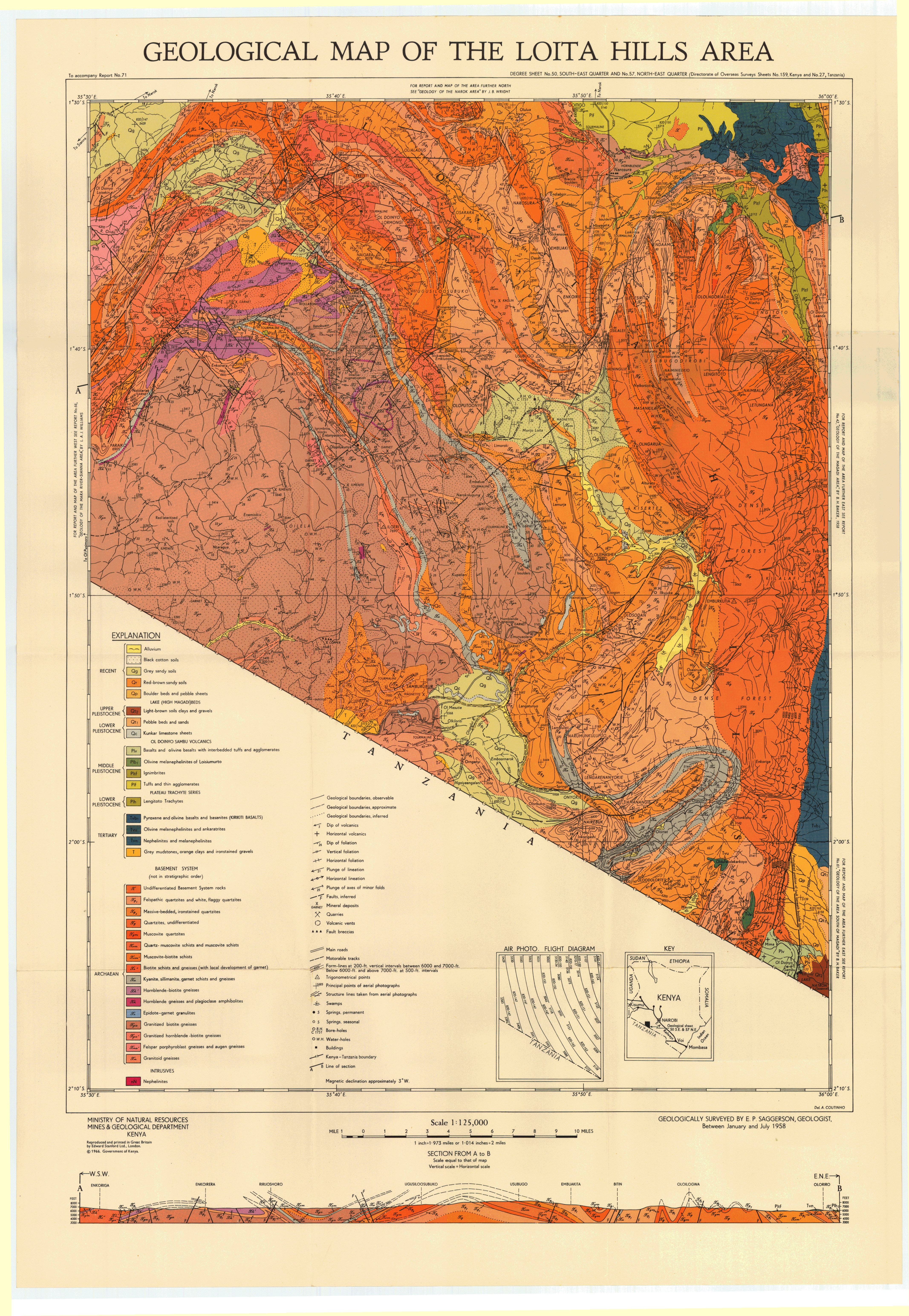
Geological Map of the Loita Hills area (50 SE,57 NE)
Scale: 1:125000,
Sheet number/quarter: 50 SE,57 NE
Year of publication: 1966
Filesize: 2,6 MB
Sheet number/quarter: 50 SE,57 NE
Year of publication: 1966
Filesize: 2,6 MB
Map coordinates
Top left: 1° 30' S, 35° 30' E
Top right: 1° 30' S, 36° 00' E
Bottom left: 2° 10' S, 36° 00' E
Bottom right: 2° 10' S, 35° 30' E
Top left: 1° 30' S, 35° 30' E
Top right: 1° 30' S, 36° 00' E
Bottom left: 2° 10' S, 36° 00' E
Bottom right: 2° 10' S, 35° 30' E

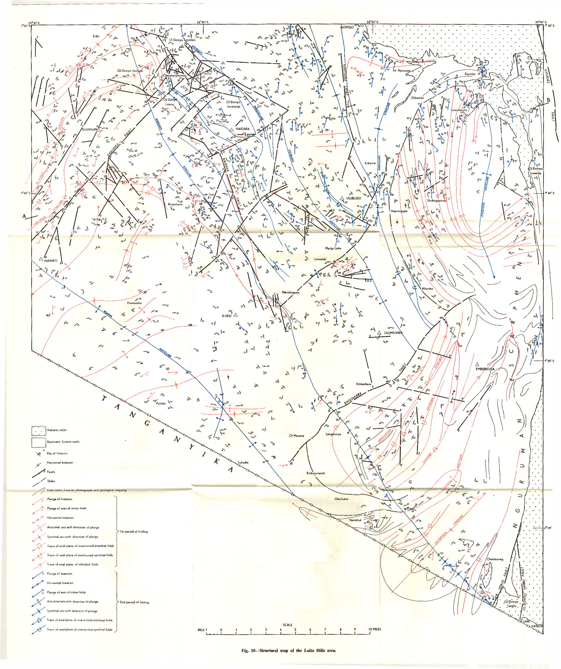
Structural map of the Loita Hills area
Scale: 1:n/a
Sheet number/quarter:
Year of publication: n/a
Filesize: 1 MB
Sheet number/quarter:
Year of publication: n/a
Filesize: 1 MB
Map coordinates
Top left: 1° 30' S, 35° 30' E
Top right: 1° 30' S, 36° 00' E
Bottom left: N/A
Bottom right: N/A
Top left: 1° 30' S, 35° 30' E
Top right: 1° 30' S, 36° 00' E
Bottom left: N/A
Bottom right: N/A
Geological map of the area the Loiya area (17 NE)
Scale: 1:125000,
Sheet number/quarter: 17 NE
Year of publication: 1964
Filesize: 6 MB
Sheet number/quarter: 17 NE
Year of publication: 1964
Filesize: 6 MB
Map coordinates
Top left: 3° 00' N, 34° 30' E
Top right: 3° 00' N, 35° 00' E
Bottom left: 2° 30' N, 35° 00' E
Bottom right: 2° 30' N, 34° 30' E
Top left: 3° 00' N, 34° 30' E
Top right: 3° 00' N, 35° 00' E
Bottom left: 2° 30' N, 35° 00' E
Bottom right: 2° 30' N, 34° 30' E
Loiyangalani (Degree Square 19)
Scale: 1:250000,
Sheet number/quarter: Degree Square 19
Year of publication: 1988
Filesize: 13,7 MB
Sheet number/quarter: Degree Square 19
Year of publication: 1988
Filesize: 13,7 MB
Map coordinates
Top left: 3° 00' N, 36° 00' E
Top right: 3° 00' N, 37° 00' E
Bottom left: 2° 00' N, 37° 00' E
Bottom right: 2° 00' N, 36° 00' E
Top left: 3° 00' N, 36° 00' E
Top right: 3° 00' N, 37° 00' E
Bottom left: 2° 00' N, 37° 00' E
Bottom right: 2° 00' N, 36° 00' E

Geological map of Longonot Volcano, The Greater Olkaria and Eburru Volcanic Complexes and adjacent areas
Scale: 1:100000,
Sheet number/quarter:
Year of publication: 1988
Filesize: 5 MB
Sheet number/quarter:
Year of publication: 1988
Filesize: 5 MB
Map coordinates
Top left: N/A
Top right: N/A
Bottom left: N/A
Bottom right: N/A
Top left: N/A
Top right: N/A
Bottom left: N/A
Bottom right: N/A

Geological map of the area the Loperot area (18 SE)
Scale: 1:125000,
Sheet number/quarter: 18 SE
Year of publication: 1966
Filesize: 6,6 MB
Sheet number/quarter: 18 SE
Year of publication: 1966
Filesize: 6,6 MB
Map coordinates
Top left: 2° 30' N, 35° 30' E
Top right: 2° 30' N, 36° 00' E
Bottom left: 2° 00' N, 36° 00' E
Bottom right: 2° 00' N, 35° 30' E
Top left: 2° 30' N, 35° 30' E
Top right: 2° 30' N, 36° 00' E
Bottom left: 2° 00' N, 36° 00' E
Bottom right: 2° 00' N, 35° 30' E

Geological map of the Loperot area (18 SE)
Scale: 1:125000,
Sheet number/quarter: 18 SE
Year of publication: 1966
Filesize: 1,9 MB
Sheet number/quarter: 18 SE
Year of publication: 1966
Filesize: 1,9 MB
Map coordinates
Top left: 2° 30' N, 35° 30' E
Top right: 2° 30' N, 36° 00' E
Bottom left: 2° 00' N, 36° 00' E
Bottom right: 2° 00' N, 35° 30' E
Top left: 2° 30' N, 35° 30' E
Top right: 2° 30' N, 36° 00' E
Bottom left: 2° 00' N, 36° 00' E
Bottom right: 2° 00' N, 35° 30' E

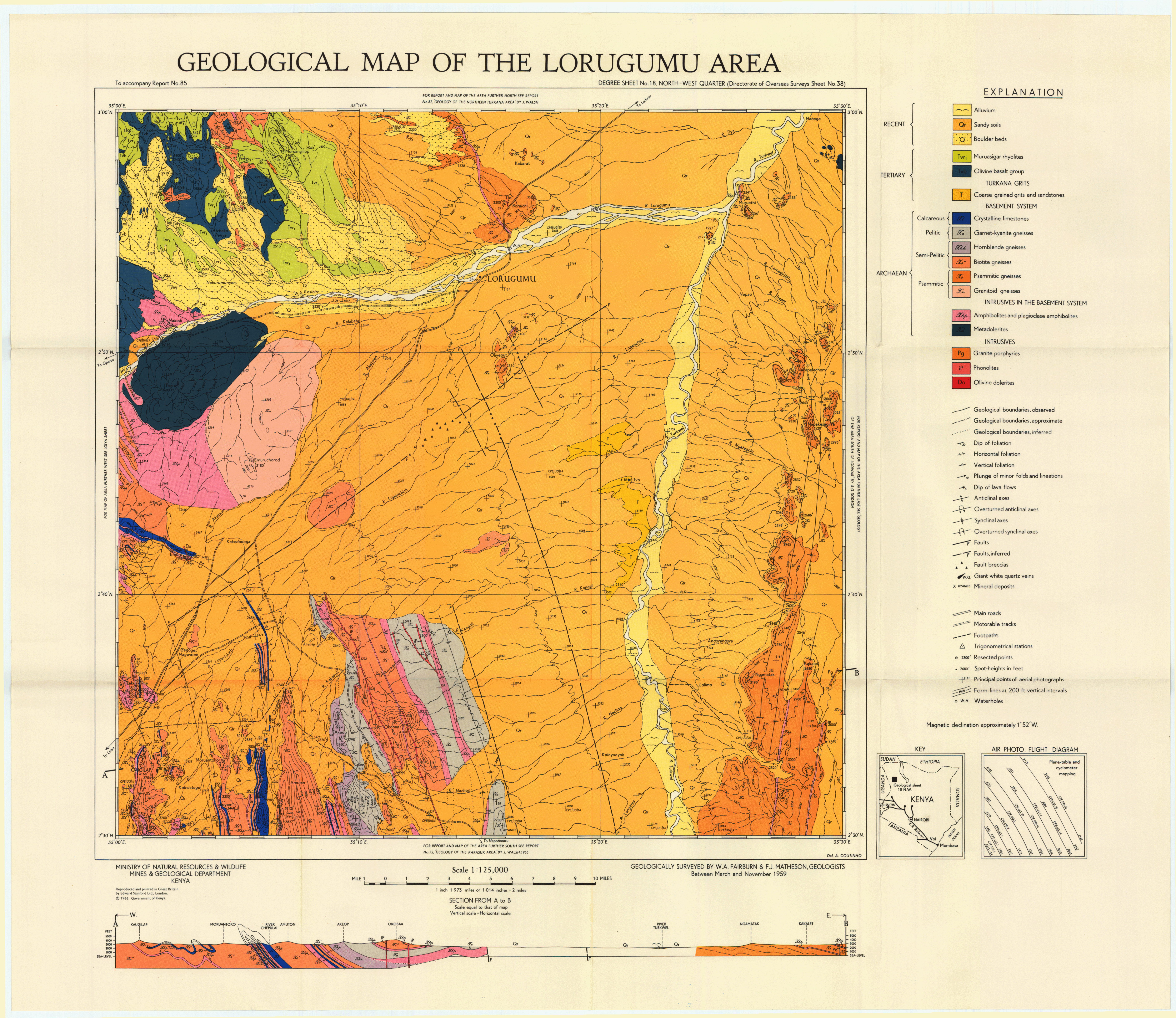
Geological map of the area the Lorugumu area (18 NW)
Scale: 1:125000,
Sheet number/quarter: 18 NW
Year of publication: 1966
Filesize: 6,5 MB
Sheet number/quarter: 18 NW
Year of publication: 1966
Filesize: 6,5 MB
Map coordinates
Top left: 3° 00' N, 35° 00' E
Top right: 3° 00' N, 35° 30' E
Bottom left: 2° 30' N, 35° 30' E
Bottom right: 2° 30' N, 35° 00' E
Top left: 3° 00' N, 35° 00' E
Top right: 3° 00' N, 35° 30' E
Bottom left: 2° 30' N, 35° 30' E
Bottom right: 2° 30' N, 35° 00' E
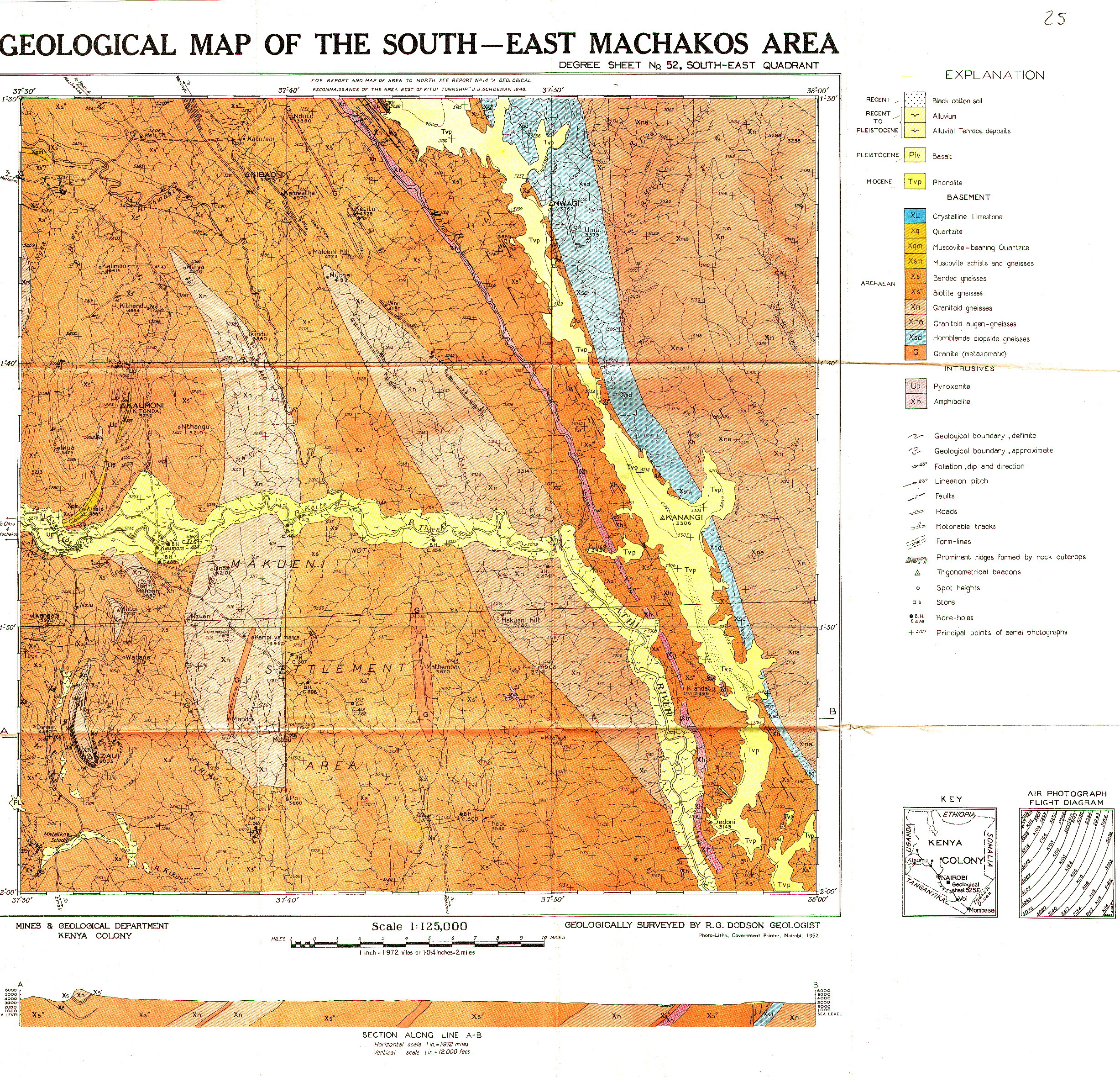
Geological map of South-East Machakos area (52 SE)
Scale: 1:125000,
Sheet number/quarter: 52 SE
Year of publication: 1952
Filesize: 2,7 MB
Sheet number/quarter: 52 SE
Year of publication: 1952
Filesize: 2,7 MB
Map coordinates
Top left: 1° 30' S, 37° 30' E
Top right: 1° 30' S, 38° 00' E
Bottom left: 2° 00' S, 38° 00' E
Bottom right: 2° 00' S, 37° 30' E
Top left: 1° 30' S, 37° 30' E
Top right: 1° 30' S, 38° 00' E
Bottom left: 2° 00' S, 38° 00' E
Bottom right: 2° 00' S, 37° 30' E
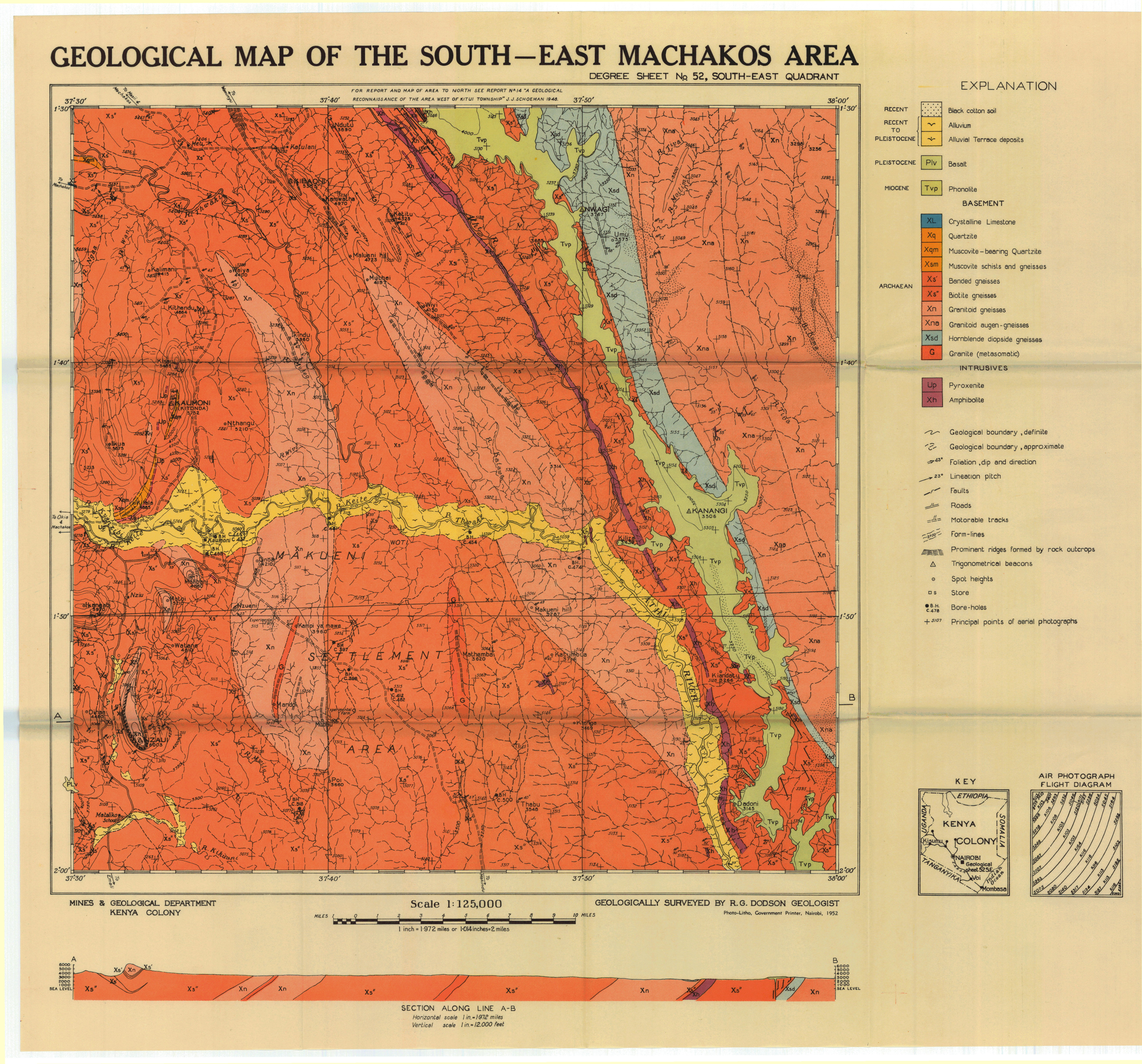
Geological map of the South East Machakos area (52 SE)
Scale: 1:125000,
Sheet number/quarter: 52 SE
Year of publication: 1952
Filesize: 6,9 MB
Sheet number/quarter: 52 SE
Year of publication: 1952
Filesize: 6,9 MB
Map coordinates
Top left: 1° 30' S, 37° 30' E
Top right: 1° 30' S, 38° 00' E
Bottom left: 2° 00' S, 38° 00' E
Bottom right: 2° 00' S, 37° 30' E
Top left: 1° 30' S, 37° 30' E
Top right: 1° 30' S, 38° 00' E
Bottom left: 2° 00' S, 38° 00' E
Bottom right: 2° 00' S, 37° 30' E
Geological map of the area the North Machakos - Thika area (52 NW)
Scale: 1:125000,
Sheet number/quarter: 52 NW
Year of publication: 1963
Filesize: 8,2 MB
Sheet number/quarter: 52 NW
Year of publication: 1963
Filesize: 8,2 MB
Map coordinates
Top left: 1° 00' S, 37° 00' E
Top right: 1° 00' S, 37° 30' E
Bottom left: 1° 30' S, 37° 30' E
Bottom right: 1° 30' S, 37° 00' E
Top left: 1° 00' S, 37° 00' E
Top right: 1° 00' S, 37° 30' E
Bottom left: 1° 30' S, 37° 30' E
Bottom right: 1° 30' S, 37° 00' E

Geological map of the Northern Machakos - Thika area (52 NW)
Scale: 1:125000,
Sheet number/quarter: 52 NW
Year of publication: 1963
Filesize: 49 MB
Sheet number/quarter: 52 NW
Year of publication: 1963
Filesize: 49 MB
Map coordinates
Top left: 1° 00' S, 37° 00' E
Top right: 1° 00' S, 37° 30' E
Bottom left: 1° 30' S, 37° 30' E
Bottom right: 1° 30' S, 37° 00' E
Top left: 1° 00' S, 37° 00' E
Top right: 1° 00' S, 37° 30' E
Bottom left: 1° 30' S, 37° 30' E
Bottom right: 1° 30' S, 37° 00' E

Geological map of the Southern Machakos District (52 SW)
Scale: 1:125000,
Sheet number/quarter: 52 SW
Year of publication: 1954
Filesize: 7,3 MB
Sheet number/quarter: 52 SW
Year of publication: 1954
Filesize: 7,3 MB
Map coordinates
Top left: 1° 30' S, 37° 00' E
Top right: 1° 30' S, 37° 30' E
Bottom left: 2° 00' S, 37° 00' E
Bottom right: 2° 00' S, 37° 30' E
Top left: 1° 30' S, 37° 00' E
Top right: 1° 30' S, 37° 30' E
Bottom left: 2° 00' S, 37° 00' E
Bottom right: 2° 00' S, 37° 30' E

Geological map of the North Machakos - Thika area (52 NW)
Scale: 1:125000,
Sheet number/quarter: 52 NW
Year of publication: 1963
Filesize: 3 MB
Sheet number/quarter: 52 NW
Year of publication: 1963
Filesize: 3 MB
Map coordinates
Top left: 1° 00' S, 37° 00' E
Top right: 1° 00' S, 37° 30' E
Bottom left: 1° 30' S, 37° 30' E
Bottom right: 1° 30' S, 37° 00' E
Top left: 1° 00' S, 37° 00' E
Top right: 1° 00' S, 37° 30' E
Bottom left: 1° 30' S, 37° 30' E
Bottom right: 1° 30' S, 37° 00' E

Geological map of the Magadi area (51 SW)
Scale: 1:125000,
Sheet number/quarter: 51 SW
Year of publication: n/a
Filesize: 7 MB
Sheet number/quarter: 51 SW
Year of publication: n/a
Filesize: 7 MB
Map coordinates
Top left: 1° 30' S, 36° 00' E
Top right: 1° 30' S, 36° 30' E
Bottom left: 2° 00' S, 36° 30' E
Bottom right: 2° 00' S, 36° 00' E
Top left: 1° 30' S, 36° 00' E
Top right: 1° 30' S, 36° 30' E
Bottom left: 2° 00' S, 36° 30' E
Bottom right: 2° 00' S, 36° 00' E

Geological map of the Magadi area (52 SW)
Scale: 1:125000,
Sheet number/quarter: 52 SW
Year of publication: 2005
Filesize: 47,4 MB
Sheet number/quarter: 52 SW
Year of publication: 2005
Filesize: 47,4 MB
Map coordinates
Top left: 1° 00' S, 36° 00' E
Top right: 1° 30' S, 36° 30' E
Bottom left: 2° 00' S, 36° 30' E
Bottom right: 2° 00' S, 36° 00' E
Top left: 1° 00' S, 36° 00' E
Top right: 1° 30' S, 36° 30' E
Bottom left: 2° 00' S, 36° 30' E
Bottom right: 2° 00' S, 36° 00' E
Geological map of the area South of Magadi (58 NW)
Scale: 1:125000,
Sheet number/quarter: 58 NW
Year of publication: 1964
Filesize: 5 MB
Sheet number/quarter: 58 NW
Year of publication: 1964
Filesize: 5 MB
Map coordinates
Top left: 2° 00' S, 36° 00' E
Top right: 2° 00' S, 36° 30' E
Bottom left: 2° 30' S, 36° 30' E
Bottom right: 2° 30' S, 36° 00' E
Top left: 2° 00' S, 36° 00' E
Top right: 2° 00' S, 36° 30' E
Bottom left: 2° 30' S, 36° 30' E
Bottom right: 2° 30' S, 36° 00' E
Geological map of the area south of Magadi (58 NW)
Scale: 1:125000,
Sheet number/quarter: 58 NW
Year of publication: 1964
Filesize: 31 MB
Sheet number/quarter: 58 NW
Year of publication: 1964
Filesize: 31 MB
Map coordinates
Top left: 2° 00' S, 36° 00' E
Top right: 2° 00' S, 36° 30' E
Bottom left: 2° 30' S, 36° 30' E
Bottom right: 2° 30' S, 36° 00' E
Top left: 2° 00' S, 36° 00' E
Top right: 2° 00' S, 36° 30' E
Bottom left: 2° 30' S, 36° 30' E
Bottom right: 2° 30' S, 36° 00' E

Geological map of the Northern Main Ethiopian Rift
Scale: 1:200000,
Sheet number/quarter:
Year of publication: 2005
Filesize: 9,3 MB
Sheet number/quarter:
Year of publication: 2005
Filesize: 9,3 MB
Map coordinates
Top left: N/A
Top right: N/A
Bottom left: N/A
Bottom right: N/A
Top left: N/A
Top right: N/A
Bottom left: N/A
Bottom right: N/A
Geological map of the Malindi area (66 NE)
Scale: 1:125000,
Sheet number/quarter: 66 NE
Year of publication: 1955
Filesize: 7,6 MB
Sheet number/quarter: 66 NE
Year of publication: 1955
Filesize: 7,6 MB
Map coordinates
Top left: 3° 00' S, 39° 30' E
Top right: N/A
Bottom left: N/A
Bottom right: 3° 30' S, 39° 30' E
Top left: 3° 00' S, 39° 30' E
Top right: N/A
Bottom left: N/A
Bottom right: 3° 30' S, 39° 30' E

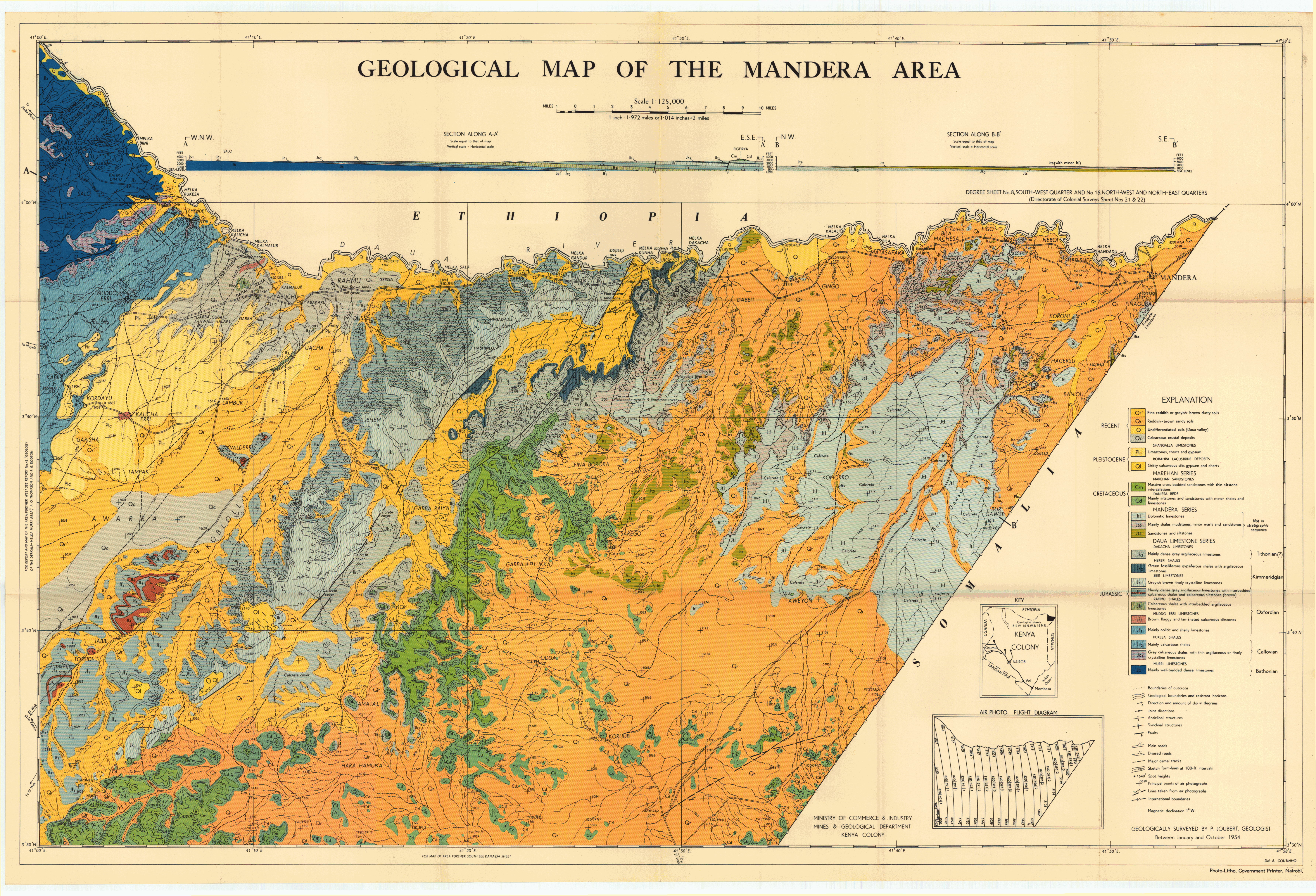
Geological map of the Mandera area (8 SW and 16 NW and NE)
Scale: 1:125000,
Sheet number/quarter: 8 SW and 16 NW and NE
Year of publication: 1954
Filesize: 10,7 MB
Sheet number/quarter: 8 SW and 16 NW and NE
Year of publication: 1954
Filesize: 10,7 MB
Map coordinates
Top left: 4° 00' N, 41° 00' E
Top right: N/A
Bottom left: 3° 30' N, 39° 30' E
Bottom right: 3° 30' N, 41° 00' E
Top left: 4° 00' N, 41° 00' E
Top right: N/A
Bottom left: 3° 30' N, 39° 30' E
Bottom right: 3° 30' N, 41° 00' E
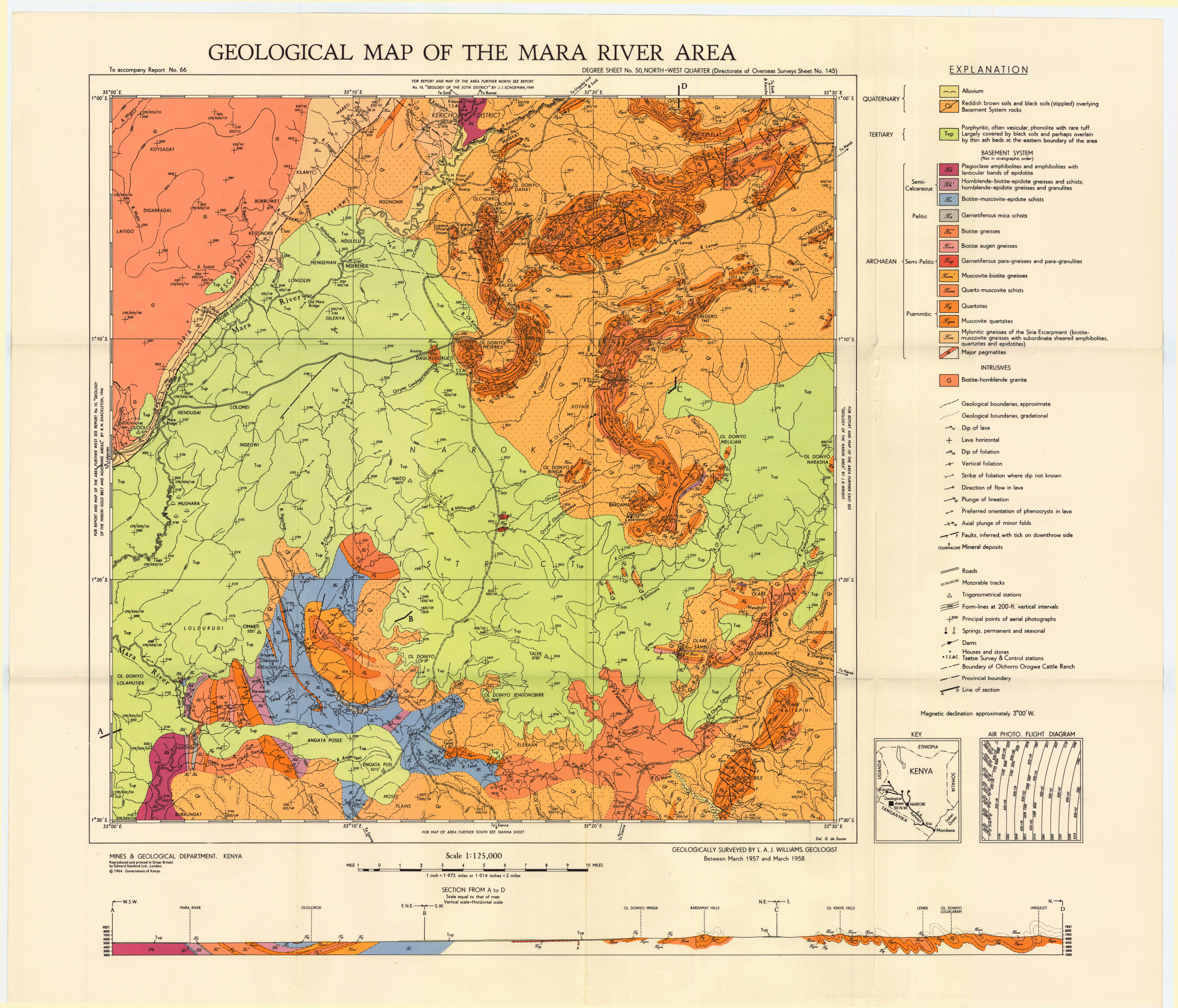
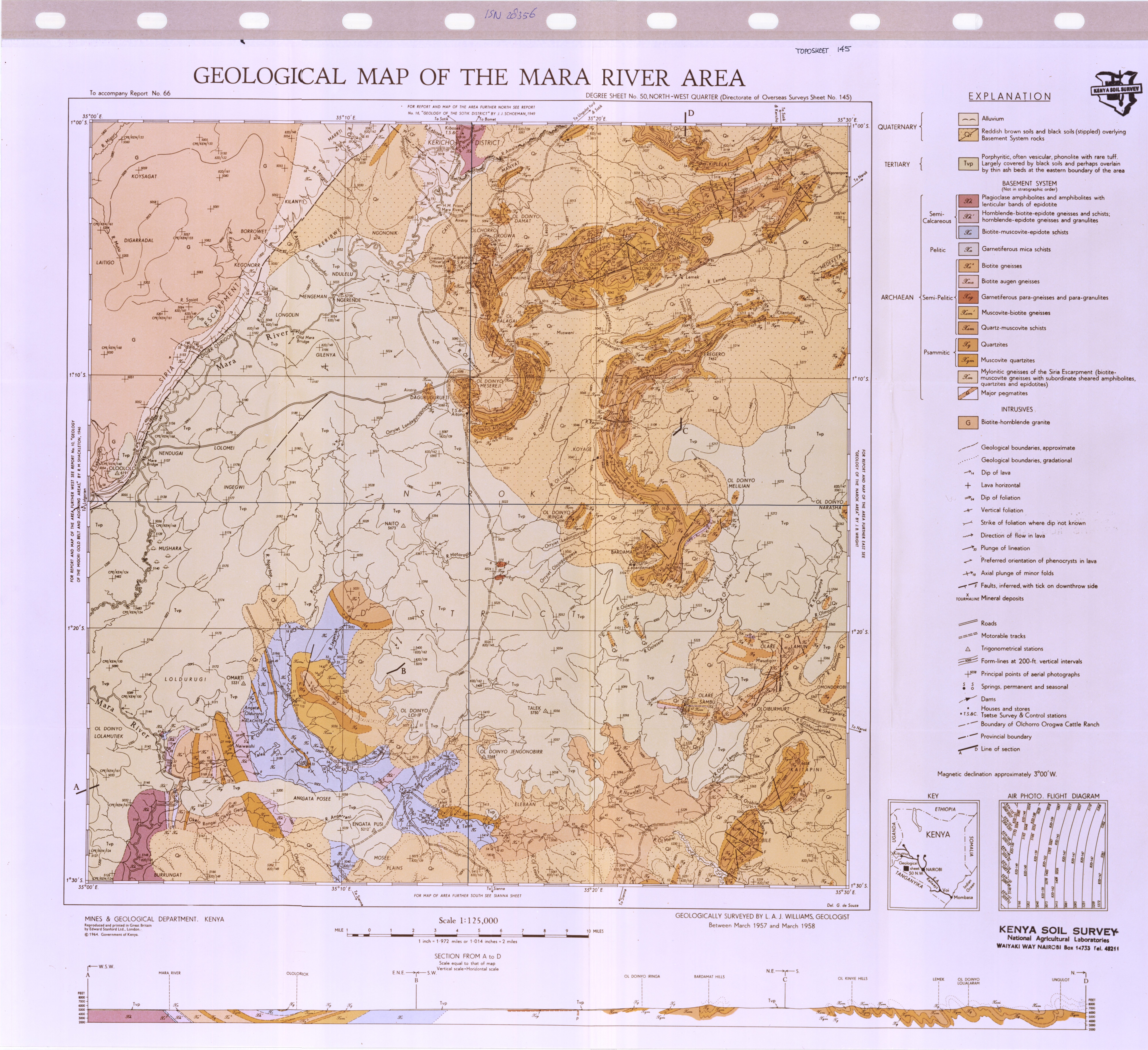
Geological map of the Mara River area (50 NW)
Scale: 1:125000,
Sheet number/quarter: 50 NW
Year of publication: 1964
Filesize: 6,5 MB
Sheet number/quarter: 50 NW
Year of publication: 1964
Filesize: 6,5 MB
Map coordinates
Top left: 1° 00' S, 35° 00' E
Top right: 1° 00' S, 35° 30' E
Bottom left: 1° 30' S, 39° 30' E
Bottom right: 1° 30' S, 35° 00' E
Top left: 1° 00' S, 35° 00' E
Top right: 1° 00' S, 35° 30' E
Bottom left: 1° 30' S, 39° 30' E
Bottom right: 1° 30' S, 35° 00' E
Geological map of the Mara River area (51 NW)
Scale: 1:125000,
Sheet number/quarter: 51 NW
Year of publication: 1964
Filesize: 40,3 MB
Sheet number/quarter: 51 NW
Year of publication: 1964
Filesize: 40,3 MB
Map coordinates
Top left: 1° 00' S, 35° 00' E
Top right: 1° 00' S, 35° 30' E
Bottom left: 1° 30' S, 35° 30' E
Bottom right: 1° 30' S, 35° 00' E
Top left: 1° 00' S, 35° 00' E
Top right: 1° 00' S, 35° 30' E
Bottom left: 1° 30' S, 35° 30' E
Bottom right: 1° 30' S, 35° 00' E
Geological map of the Mara River area (50 NW)
Scale: 1:125000,
Sheet number/quarter: 50 NW
Year of publication: 1964
Filesize: 2,4 MB
Sheet number/quarter: 50 NW
Year of publication: 1964
Filesize: 2,4 MB
Map coordinates
Top left: 1° 00' S, 35° 30' E
Top right: 1° 00' S, 35° 30' E
Bottom left: 1° 30' S, 35° 30' E
Bottom right: 1° 30' S, 35° 00' E
Top left: 1° 00' S, 35° 30' E
Top right: 1° 00' S, 35° 30' E
Bottom left: 1° 30' S, 35° 30' E
Bottom right: 1° 30' S, 35° 00' E

Geological map of Maralal (27)
Scale: 1:250000,
Sheet number/quarter: 27
Year of publication: 1987
Filesize: 4,4 MB
Sheet number/quarter: 27
Year of publication: 1987
Filesize: 4,4 MB
Map coordinates
Top left: 2° 00' N, 36° 00' E
Top right: 2° 00' N, 37° 00' E
Bottom left: 1° 00' N, 37° 00' E
Bottom right: 1° 00' N, 36° 00' E
Top left: 2° 00' N, 36° 00' E
Top right: 2° 00' N, 37° 00' E
Bottom left: 1° 00' N, 37° 00' E
Bottom right: 1° 00' N, 36° 00' E
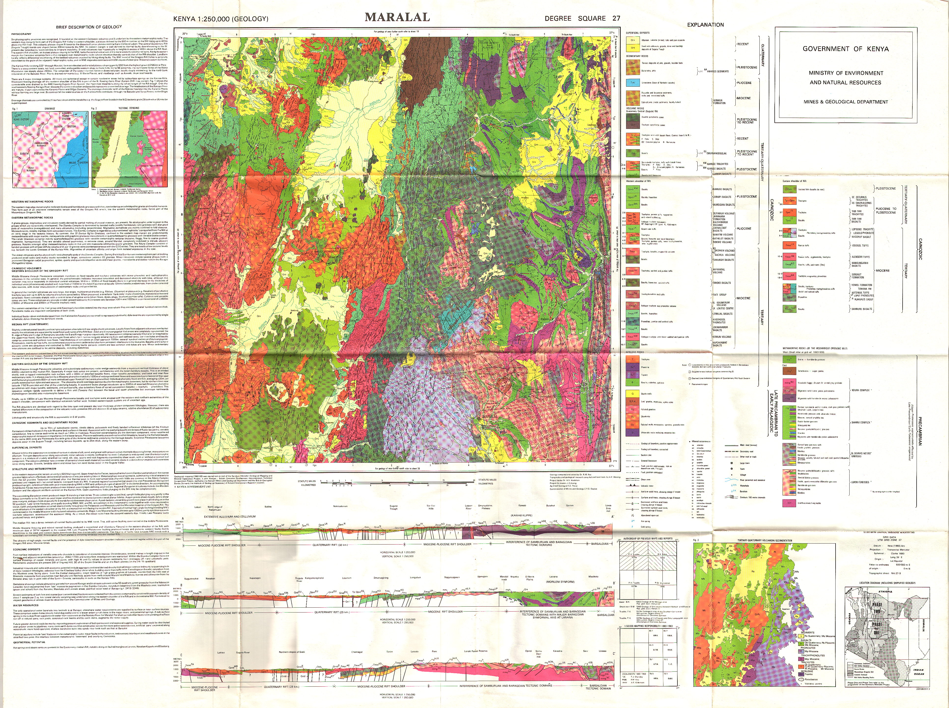
Maralal (Degree Square 27)
Scale: 1:250000,
Sheet number/quarter: Degree Square 27
Year of publication: 1987
Filesize: 4,7 MB
Sheet number/quarter: Degree Square 27
Year of publication: 1987
Filesize: 4,7 MB
Map coordinates
Top left: 2° 00' N, 36° 00' E
Top right: 2° 00' N, 37° 00' E
Bottom left: 1° 00' N, 36° 00' E
Bottom right: 1° 00' N, 37° 00' E
Top left: 2° 00' N, 36° 00' E
Top right: 2° 00' N, 37° 00' E
Bottom left: 1° 00' N, 36° 00' E
Bottom right: 1° 00' N, 37° 00' E

Maralal (Degree Square 27)
Scale: 1:250000,
Sheet number/quarter: Degree Square 27
Year of publication: 1987
Filesize: 13,3 MB
Sheet number/quarter: Degree Square 27
Year of publication: 1987
Filesize: 13,3 MB
Map coordinates
Top left: 2° 00' N, 36° 00' E
Top right: 2° 00' N, 37° 00' E
Bottom left: 1° 00' N, 36° 00' E
Bottom right: 1° 00' N, 37° 00' E
Top left: 2° 00' N, 36° 00' E
Top right: 2° 00' N, 37° 00' E
Bottom left: 1° 00' N, 36° 00' E
Bottom right: 1° 00' N, 37° 00' E

Physiographic sketch map of the Maralal area and Districts to the West
Scale: 1:n/a
Sheet number/quarter:
Year of publication: n/a
Filesize: 0,7 MB
Sheet number/quarter:
Year of publication: n/a
Filesize: 0,7 MB
Map coordinates
Top left: N/A
Top right: N/A
Bottom left: N/A
Bottom right: N/A
Top left: N/A
Top right: N/A
Bottom left: N/A
Bottom right: N/A

Geological map of the Mackinnon road -Mariakani area (66 SW)
Scale: 1:125000,
Sheet number/quarter: 66 SW
Year of publication: 1950
Filesize: 6,1 MB
Sheet number/quarter: 66 SW
Year of publication: 1950
Filesize: 6,1 MB
Map coordinates
Top left: 3° 30' S, 39° 00' E
Top right: 3° 30' S, 39° 30' E
Bottom left: 4° 00' S, 39° 30' E
Bottom right: 4° 00' S, 39° 30' E
Top left: 3° 30' S, 39° 00' E
Top right: 3° 30' S, 39° 30' E
Bottom left: 4° 00' S, 39° 30' E
Bottom right: 4° 00' S, 39° 30' E

Geological map of Marsabit (20)
Scale: 1:250000,
Sheet number/quarter: 20
Year of publication: 1987
Filesize: 3,7 MB
Sheet number/quarter: 20
Year of publication: 1987
Filesize: 3,7 MB
Map coordinates
Top left: 3° 00' N, 37° 00' E
Top right: 3° 00' N, 38° 00' E
Bottom left: 2° 00' N, 38° 00' E
Bottom right: 2° 00' N, 37° 00' E
Top left: 3° 00' N, 37° 00' E
Top right: 3° 00' N, 38° 00' E
Bottom left: 2° 00' N, 38° 00' E
Bottom right: 2° 00' N, 37° 00' E

Geological map of the area S.E. of Marsabit (13&21 NE and NW)
Scale: 1:300000,
Sheet number/quarter: 13&21 NE and NW
Year of publication: 1969
Filesize: 2,3 MB
Sheet number/quarter: 13&21 NE and NW
Year of publication: 1969
Filesize: 2,3 MB
Map coordinates
Top left: 3° 48' N, 38° 00' E
Top right: 3° 48' N, 39° 00' E
Bottom left: 2° 30' N, 38° 00' E
Bottom right: 2° 30' S, 35° 00' E
Top left: 3° 48' N, 38° 00' E
Top right: 3° 48' N, 39° 00' E
Bottom left: 2° 30' N, 38° 00' E
Bottom right: 2° 30' S, 35° 00' E
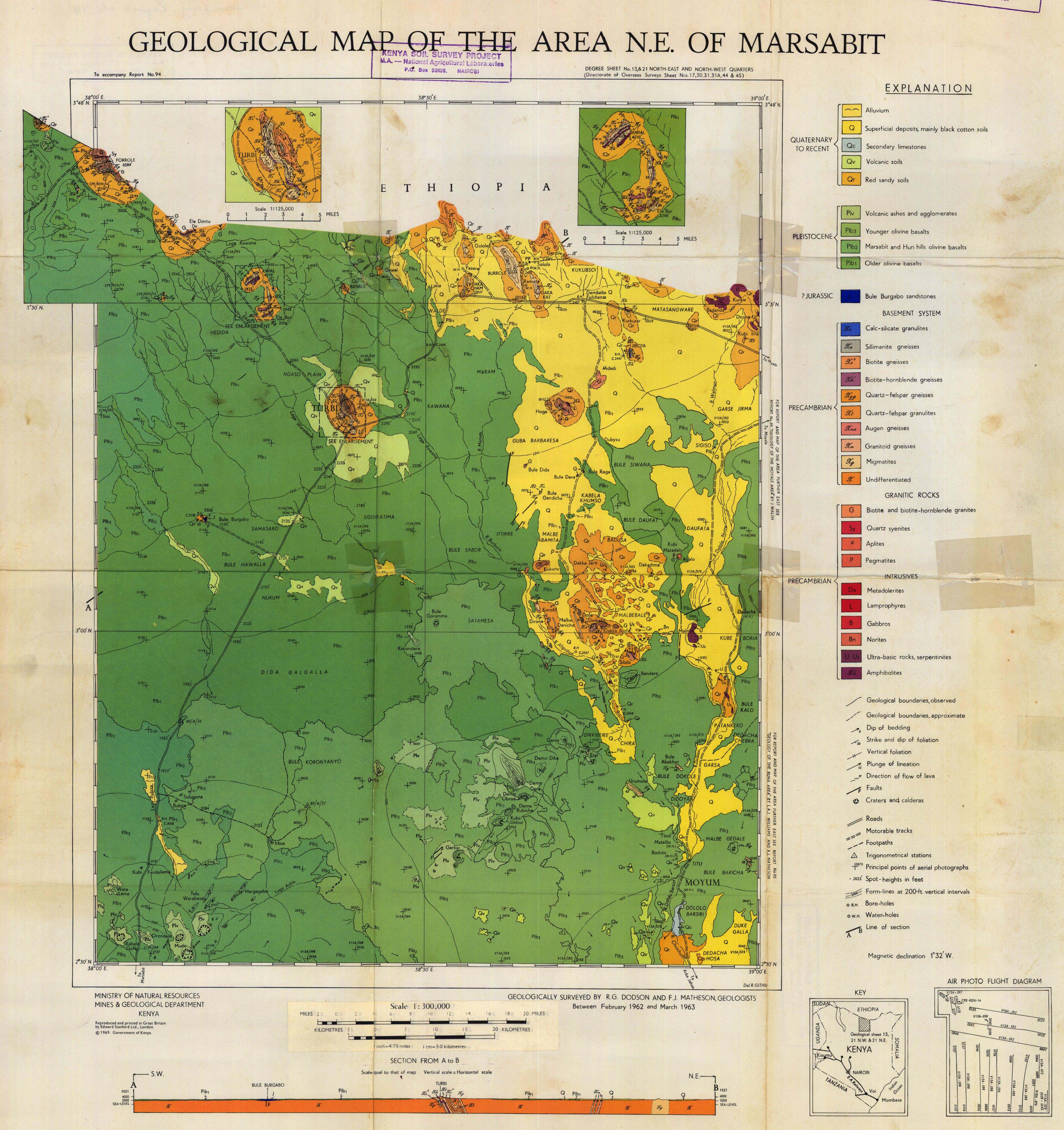
Geological map of the N.E. of Marsabit (13 and 21 NE and NW)
Scale: 1:300000,
Sheet number/quarter: 13 and 21 NE and NW
Year of publication: 1969
Filesize: 5,4 MB
Sheet number/quarter: 13 and 21 NE and NW
Year of publication: 1969
Filesize: 5,4 MB
Map coordinates
Top left: 3° 48' N, 38° 00' E
Top right: 3° 48' N, 39° 00' E
Bottom left: 2° 30' N, 39° 00' E
Bottom right: 2° 30' N, 38° 00' E
Top left: 3° 48' N, 38° 00' E
Top right: 3° 48' N, 39° 00' E
Bottom left: 2° 30' N, 39° 00' E
Bottom right: 2° 30' N, 38° 00' E
Marsabit (Degree Square 20)
Scale: 1:250000,
Sheet number/quarter: Degree Square 20
Year of publication: 1987
Filesize: 9,1 MB
Sheet number/quarter: Degree Square 20
Year of publication: 1987
Filesize: 9,1 MB
Map coordinates
Top left: 3° 00' N, 37° 00' E
Top right: 3° 00' N, 38° 00' E
Bottom left: 2° 00' N, 37° 00' E
Bottom right: 2° 00' N, 38° 00' E
Top left: 3° 00' N, 37° 00' E
Top right: 3° 00' N, 38° 00' E
Bottom left: 2° 00' N, 37° 00' E
Bottom right: 2° 00' N, 38° 00' E

Geological map of the area Mau area (42 SE)
Scale: 1:125000,
Sheet number/quarter: 42 SE
Year of publication: 1969
Filesize: 3 MB
Sheet number/quarter: 42 SE
Year of publication: 1969
Filesize: 3 MB
Map coordinates
Top left: 0° 30' S, 35° 30' E
Top right: 0° 30' S, 36° 00' E
Bottom left: 1° 00' S, 36° 00' E
Bottom right: 1° 00' S, 35° 30' E
Top left: 0° 30' S, 35° 30' E
Top right: 0° 30' S, 36° 00' E
Bottom left: 1° 00' S, 36° 00' E
Bottom right: 1° 00' S, 35° 30' E

Geological map of the Melka Murri area (7 SE and 15 NE)
Scale: 1:125000,
Sheet number/quarter: 7 SE and 15 NE
Year of publication: 1953
Filesize: 6,2 MB
Sheet number/quarter: 7 SE and 15 NE
Year of publication: 1953
Filesize: 6,2 MB
Map coordinates
Top left: 4° 18' N, 40° 30' E
Top right: 4° 18' N, 41° 00' E
Bottom left: 3° 30' N, 40° 30' E
Bottom right: 3° 30' N, 41° 00' E
Top left: 4° 18' N, 40° 30' E
Top right: 4° 18' N, 41° 00' E
Bottom left: 3° 30' N, 40° 30' E
Bottom right: 3° 30' N, 41° 00' E

Geological map of the Meru Isiolo area (36 SE)
Scale: 1:125000,
Sheet number/quarter: 36 SE
Year of publication: 1954
Filesize: 6,4 MB
Sheet number/quarter: 36 SE
Year of publication: 1954
Filesize: 6,4 MB
Map coordinates
Top left: 0° 30' N, 37° 30' E
Top right: 0° 30' N, 38° 00' E
Bottom left: 4° 00' N, 37° 30' E
Bottom right: 0° 00' N, 38° 00' E
Top left: 0° 30' N, 37° 30' E
Top right: 0° 30' N, 38° 00' E
Bottom left: 4° 00' N, 37° 30' E
Bottom right: 0° 00' N, 38° 00' E

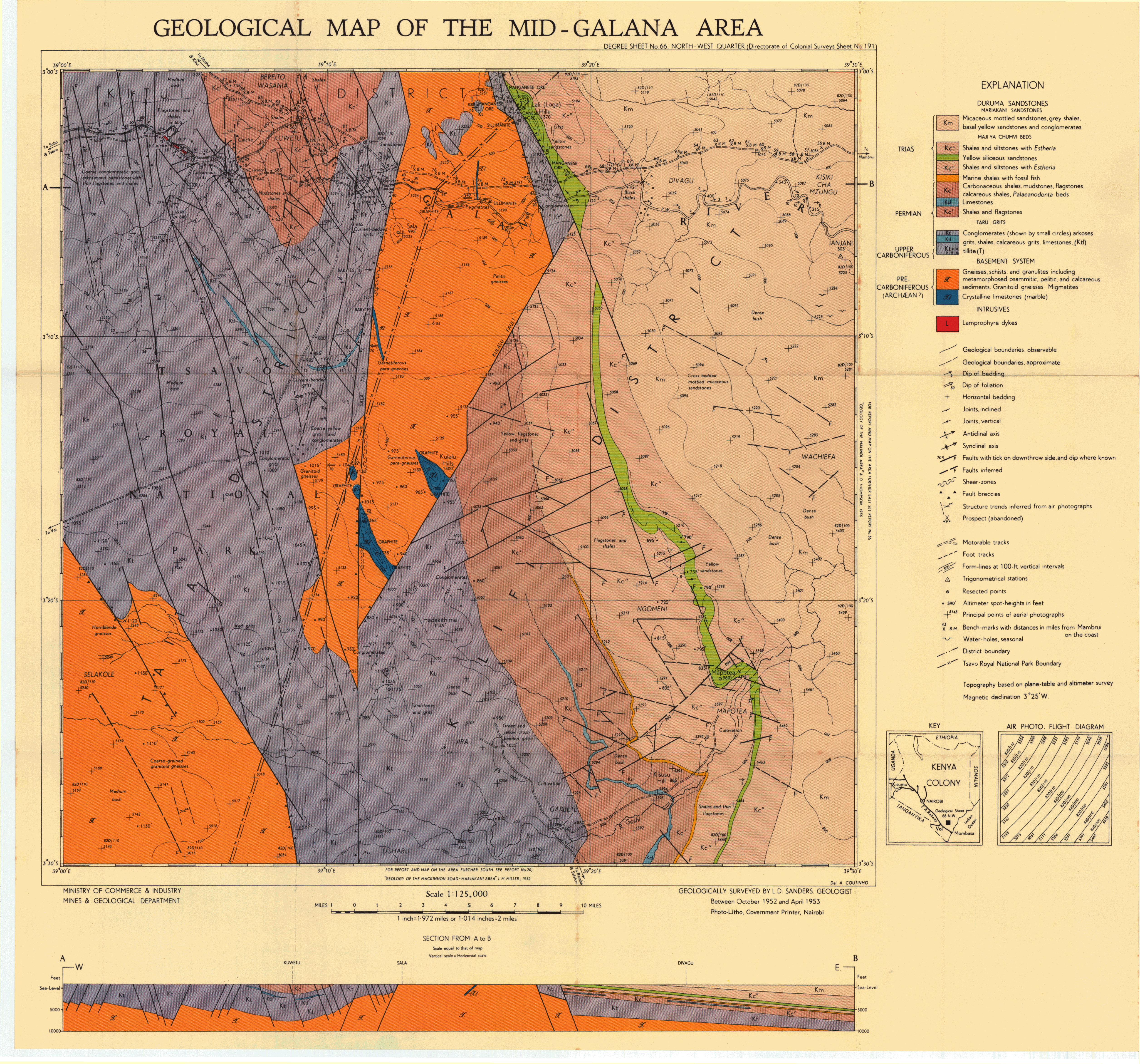
Geological map of the Mid Galana area (66 NW)
Scale: 1:125000,
Sheet number/quarter: 66 NW
Year of publication: Between 1952 and 1953
Filesize: 7,5 MB
Sheet number/quarter: 66 NW
Year of publication: Between 1952 and 1953
Filesize: 7,5 MB
Map coordinates
Top left: 3° 00' S, 39° 00' E
Top right: 3° 00' S, 39° 30' E
Bottom left: 3° 30' S, 39° 30' E
Bottom right: 3° 30' S, 39° 00' E
Top left: 3° 00' S, 39° 00' E
Top right: 3° 00' S, 39° 30' E
Bottom left: 3° 30' S, 39° 30' E
Bottom right: 3° 30' S, 39° 00' E
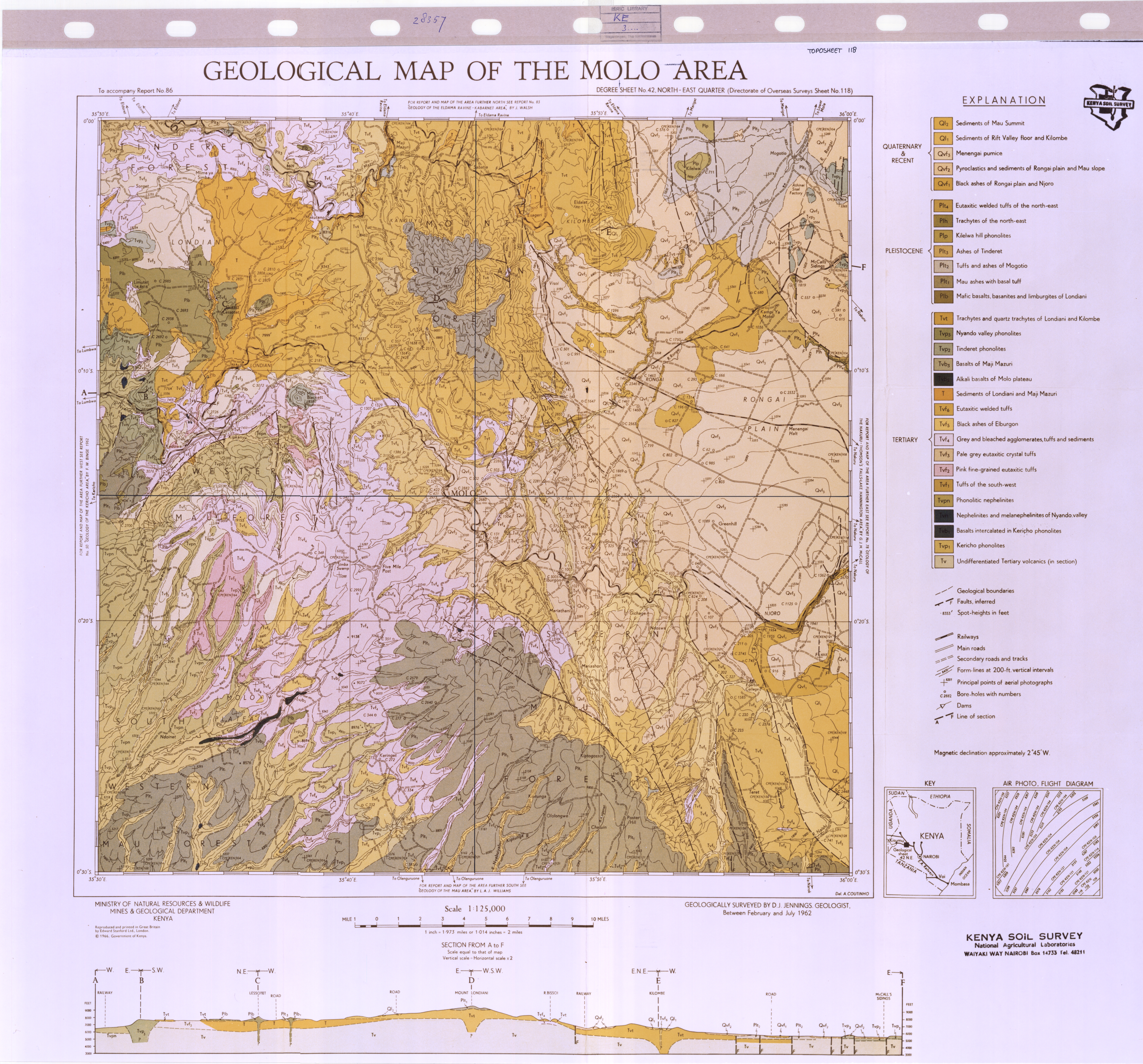
Geological map of the Molo area (42 NE)
Scale: 1:125000,
Sheet number/quarter: 42 NE
Year of publication: 1966
Filesize: 7,8 MB
Sheet number/quarter: 42 NE
Year of publication: 1966
Filesize: 7,8 MB
Map coordinates
Top left: 0° 00' S, 35° 30' E
Top right: 0° 00' S, 36° 00' E
Bottom left: 0° 30' S, 36° 00' E
Bottom right: 0° 30' S, 35° 30' E
Top left: 0° 00' S, 35° 30' E
Top right: 0° 00' S, 36° 00' E
Bottom left: 0° 30' S, 36° 00' E
Bottom right: 0° 30' S, 35° 30' E

Geological map of the Molo area (43 NE)
Scale: 1:125000,
Sheet number/quarter: 43 NE
Year of publication: 1966
Filesize: 41,3 MB
Sheet number/quarter: 43 NE
Year of publication: 1966
Filesize: 41,3 MB
Map coordinates
Top left: 1° 00' S, 35° 30' E
Top right: 1° 00' S, 36° 00' E
Bottom left: 1° 30' S, 36° 00' E
Bottom right: 1° 30' S, 35° 30' E
Top left: 1° 00' S, 35° 30' E
Top right: 1° 00' S, 36° 00' E
Bottom left: 1° 30' S, 36° 00' E
Bottom right: 1° 30' S, 35° 30' E
Geological map of the Mombasa - Kwale area (200, 201 and 202)
Scale: 1:100000,
Sheet number/quarter: 200, 201 and 202
Year of publication: 1953
Filesize: 4,4 MB
Sheet number/quarter: 200, 201 and 202
Year of publication: 1953
Filesize: 4,4 MB
Map coordinates
Top left: N/A
Top right: N/A
Bottom left: N/A
Bottom right: N/A
Top left: N/A
Top right: N/A
Bottom left: N/A
Bottom right: N/A

Geological map of the Mombasa - Kwale area (southern part)
Scale: 1:125000,
Sheet number/quarter:
Year of publication: 1953
Filesize: 5,1 MB
Sheet number/quarter:
Year of publication: 1953
Filesize: 5,1 MB
Map coordinates
Top left: N/A
Top right: N/A
Bottom left: N/A
Bottom right: N/A
Top left: N/A
Top right: N/A
Bottom left: N/A
Bottom right: N/A
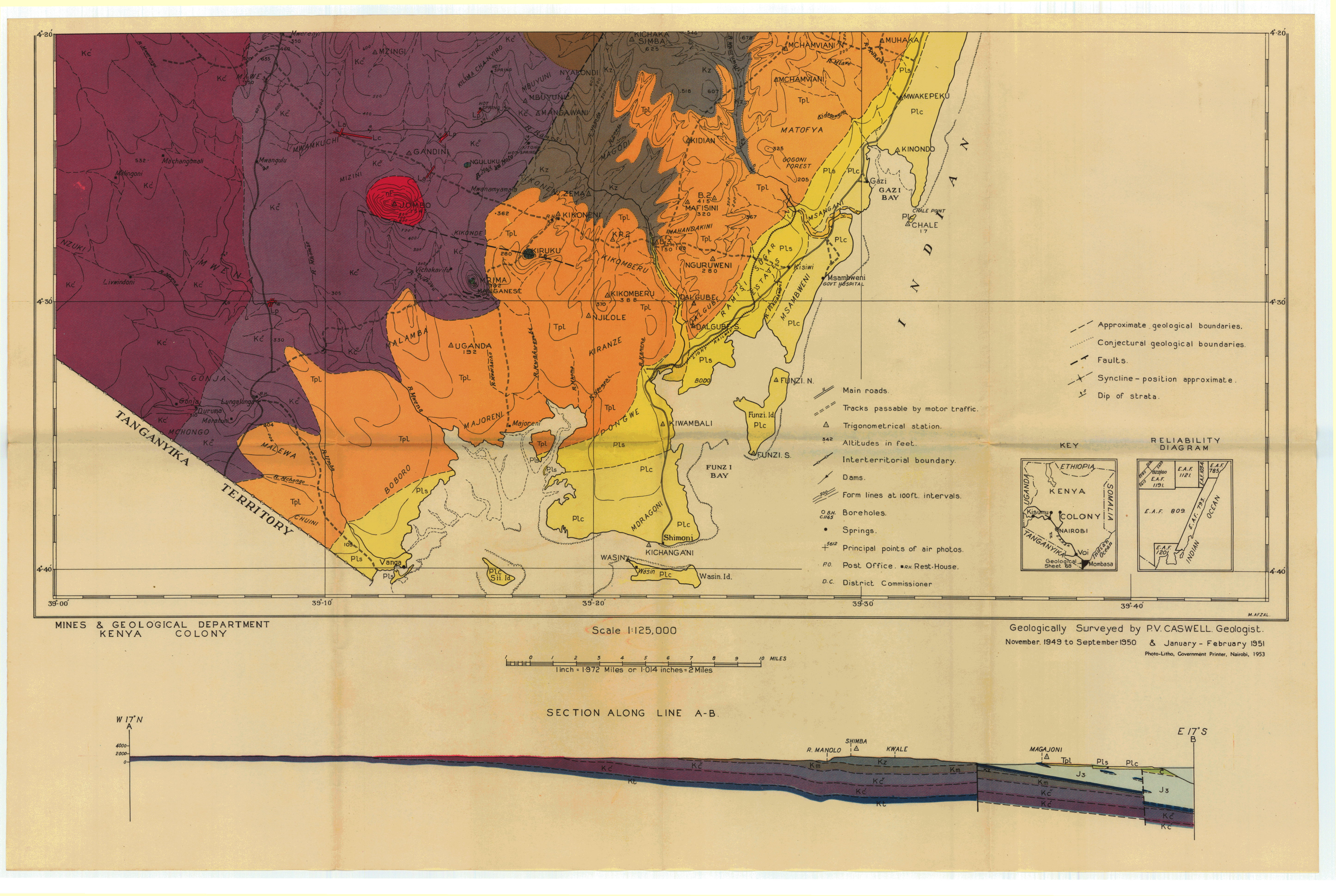
Geological map of the Mombasa Kwale area (69)
Scale: 1:125000,
Sheet number/quarter: 69
Year of publication: n/a
Filesize: 7,3 MB
Sheet number/quarter: 69
Year of publication: n/a
Filesize: 7,3 MB
Map coordinates
Top left: N/A
Top right: N/A
Bottom left: N/A
Bottom right: N/A
Top left: N/A
Top right: N/A
Bottom left: N/A
Bottom right: N/A

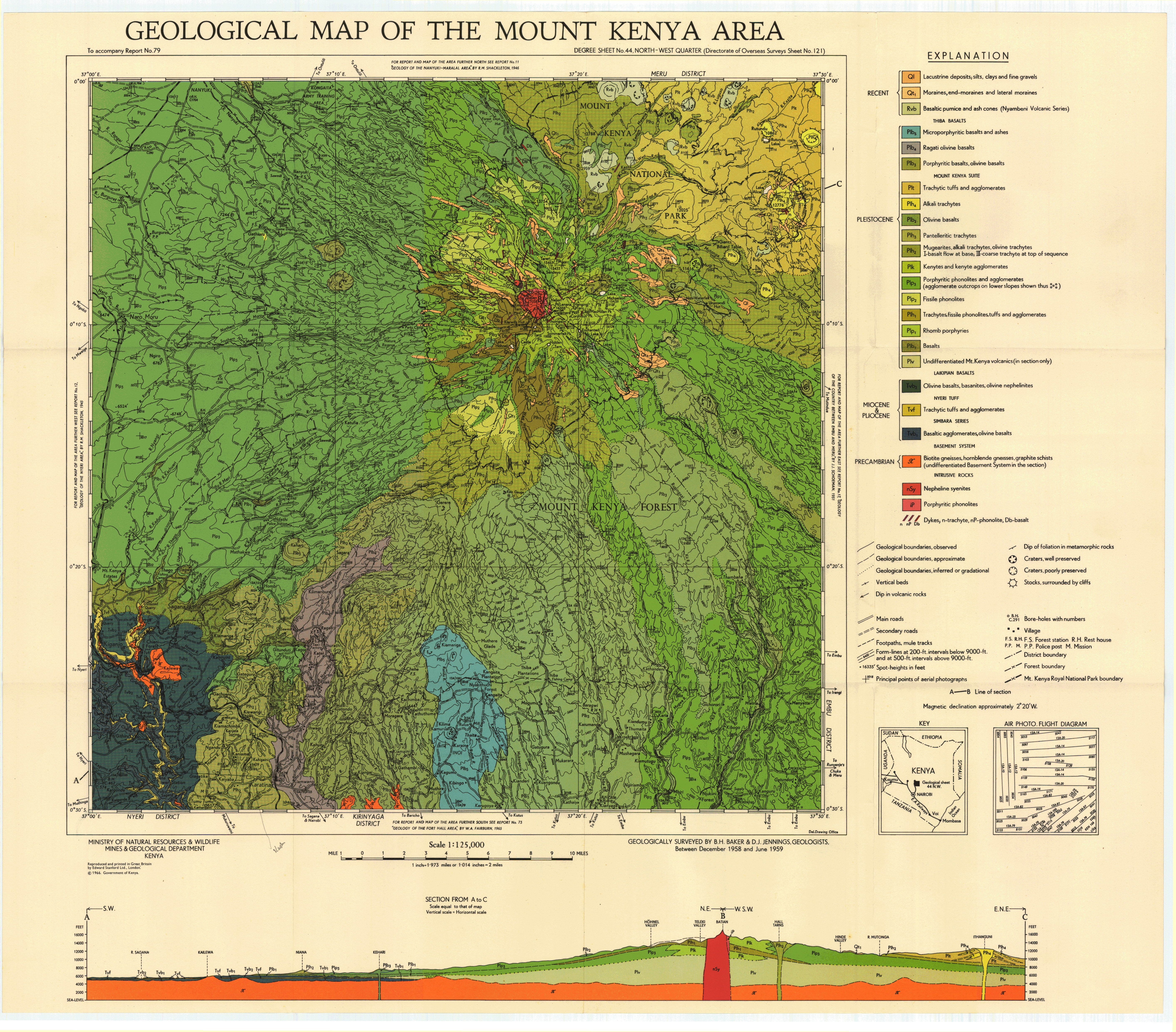
Geological map of the Mount Kenya area (44 NW)
Scale: 1:125000,
Sheet number/quarter: 44 NW
Year of publication: 1966
Filesize: 3,3 MB
Sheet number/quarter: 44 NW
Year of publication: 1966
Filesize: 3,3 MB
Map coordinates
Top left: 0° 00' S, 37° 00' E
Top right: 0° 00' 37, 30° E' E
Bottom left: 0° 30' S, 37° 30' E
Bottom right: 0° 30' S, 37° 00' E
Top left: 0° 00' S, 37° 00' E
Top right: 0° 00' 37, 30° E' E
Bottom left: 0° 30' S, 37° 30' E
Bottom right: 0° 30' S, 37° 00' E

Geological map of the Mount Kenya area (44 NW)
Scale: 1:125000,
Sheet number/quarter: 44 NW
Year of publication: 1966
Filesize: 7,2 MB
Sheet number/quarter: 44 NW
Year of publication: 1966
Filesize: 7,2 MB
Map coordinates
Top left: 0° 00' S, 37° 00' E
Top right: 0° 00' 37, 30° E' E
Bottom left: 0° 30' S, 37° 30' E
Bottom right: 0° 30' S, 37° 00' E
Top left: 0° 00' S, 37° 00' E
Top right: 0° 00' 37, 30° E' E
Bottom left: 0° 30' S, 37° 30' E
Bottom right: 0° 30' S, 37° 00' E
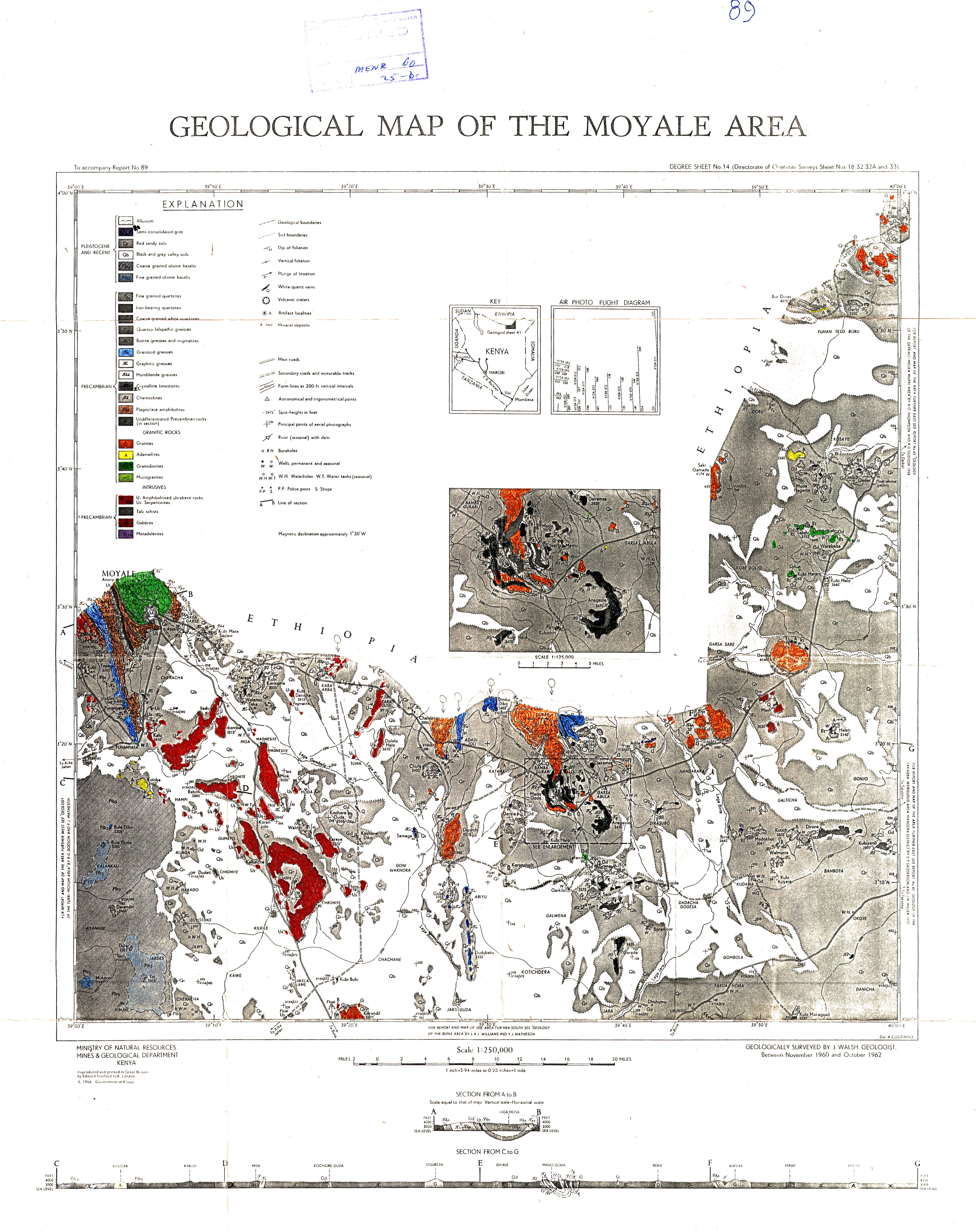
Geological map of the Moyale area (14)
Scale: 1:250000,
Sheet number/quarter: 14
Year of publication: 1966
Filesize: 6,2 MB
Sheet number/quarter: 14
Year of publication: 1966
Filesize: 6,2 MB
Map coordinates
Top left: 4° 00' N, 39° 00' E
Top right: 4° 00' N, 40° 00' E
Bottom left: 3° 00' N, 37° 30' E
Bottom right: 3° 00' N, 40° 00' E
Top left: 4° 00' N, 39° 00' E
Top right: 4° 00' N, 40° 00' E
Bottom left: 3° 00' N, 37° 30' E
Bottom right: 3° 00' N, 40° 00' E
Geological map of the Moyale area (14)
Scale: 1:125000,
Sheet number/quarter: 14
Year of publication: 1966
Filesize: 4,6 MB
Sheet number/quarter: 14
Year of publication: 1966
Filesize: 4,6 MB
Map coordinates
Top left: 4° 00' N, 35° 00' E
Top right: 4° 00' N, 40° 00' E
Bottom left: 3° 00' N, 40° 00' E
Bottom right: 3° 00' N, 39° 00' E
Top left: 4° 00' N, 35° 00' E
Top right: 4° 00' N, 40° 00' E
Bottom left: 3° 00' N, 40° 00' E
Bottom right: 3° 00' N, 39° 00' E
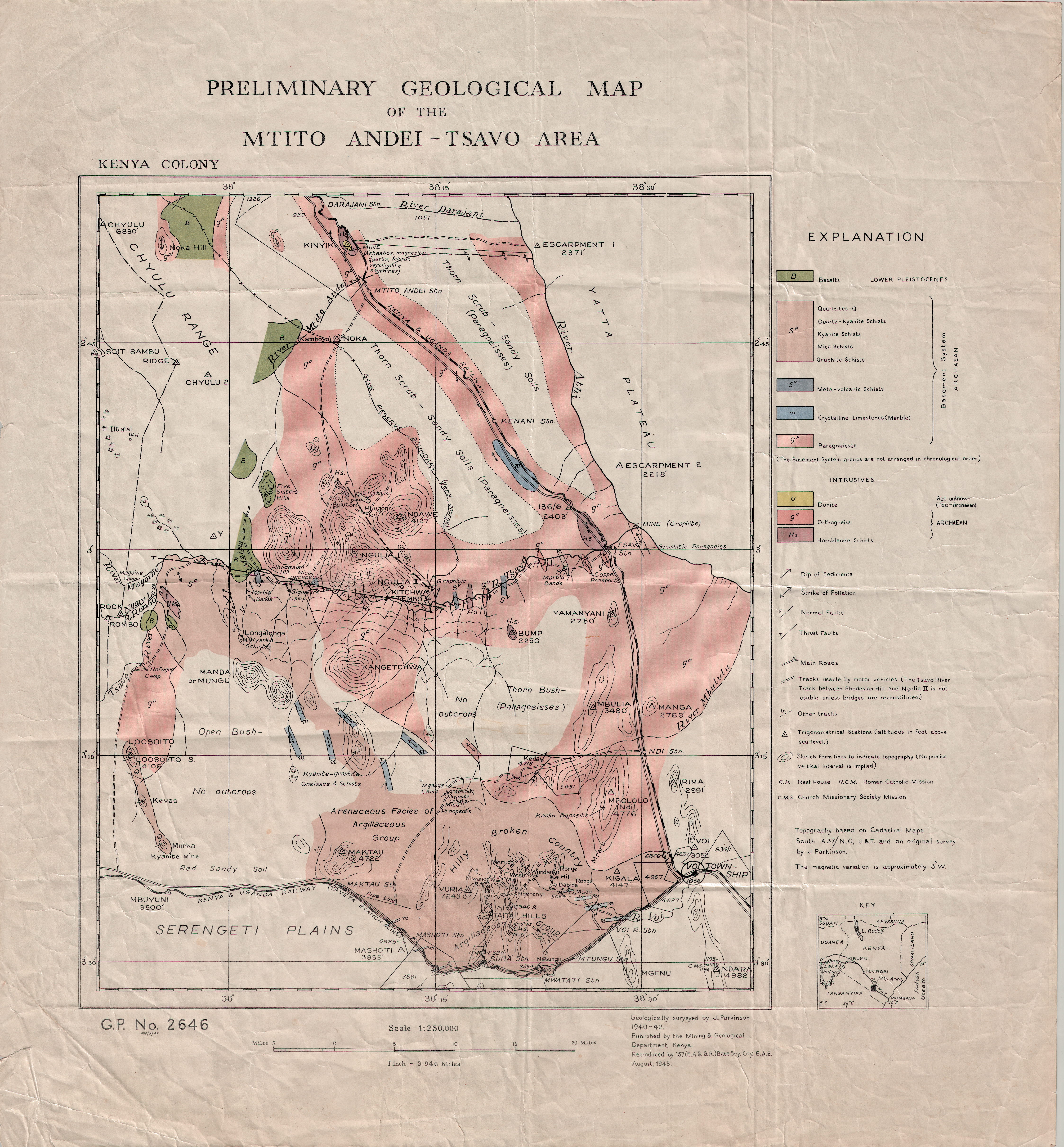
Preliminary Geological map of the Mtito - Andei Tsavo area
Scale: 1:250000,
Sheet number/quarter:
Year of publication: 1945
Filesize: 5,9 MB
Sheet number/quarter:
Year of publication: 1945
Filesize: 5,9 MB
Map coordinates
Top left: N/A
Top right: N/A
Bottom left: N/A
Bottom right: N/A
Top left: N/A
Top right: N/A
Bottom left: N/A
Bottom right: N/A
Outlines of the geology of the mtito andei-tsavo areakenya colony
Year of publication: 1947
Filesize: 2,6 MB
Filesize: 2,6 MB
geology of the mwatate quadrangle and the vanadium grossularite deposits of the area
Year of publication: 1979
Filesize: 9,5 MB
Filesize: 9,5 MB
Geological map of the Mwatate Quadrangle area
Scale: 1:n/a
Sheet number/quarter:
Year of publication: 1978
Filesize: 11,3 MB
Sheet number/quarter:
Year of publication: 1978
Filesize: 11,3 MB
Map coordinates
Top left: 3° 30' S, 38° 15' E
Top right: 3° 30' S, 38° 30' E
Bottom left: 3° 45' S, 38° 15' E
Bottom right: 3° 45' S, 38° 30' E
Top left: 3° 30' S, 38° 15' E
Top right: 3° 30' S, 38° 30' E
Bottom left: 3° 45' S, 38° 15' E
Bottom right: 3° 45' S, 38° 30' E

Geological map of the Mwingi area (45 SW)
Scale: 1:125000,
Sheet number/quarter: 45 SW
Year of publication: 1955
Filesize: 7,1 MB
Sheet number/quarter: 45 SW
Year of publication: 1955
Filesize: 7,1 MB
Map coordinates
Top left: 0° 30' S, 38° 00' E
Top right: 0° 30' S, 38° 30' E
Bottom left: 1° 00' S, 38° 30' E
Bottom right: 1° 00' S, 38° 00' E
Top left: 0° 30' S, 38° 00' E
Top right: 0° 30' S, 38° 30' E
Bottom left: 1° 00' S, 38° 30' E
Bottom right: 1° 00' S, 38° 00' E

Geological map of the Nairobi area (51 NE)
Scale: 1:125000,
Sheet number/quarter: 51 NE
Year of publication: 1971
Filesize: 7,6 MB
Sheet number/quarter: 51 NE
Year of publication: 1971
Filesize: 7,6 MB
Map coordinates
Top left: 1° 00' S, 36° 30' E
Top right: 1° 00' S, 37° 00' E
Bottom left: 1° 30' S, 37° 00' E
Bottom right: 1° 30' S, 36° 30' E
Top left: 1° 00' S, 36° 30' E
Top right: 1° 00' S, 37° 00' E
Bottom left: 1° 30' S, 37° 00' E
Bottom right: 1° 30' S, 36° 30' E
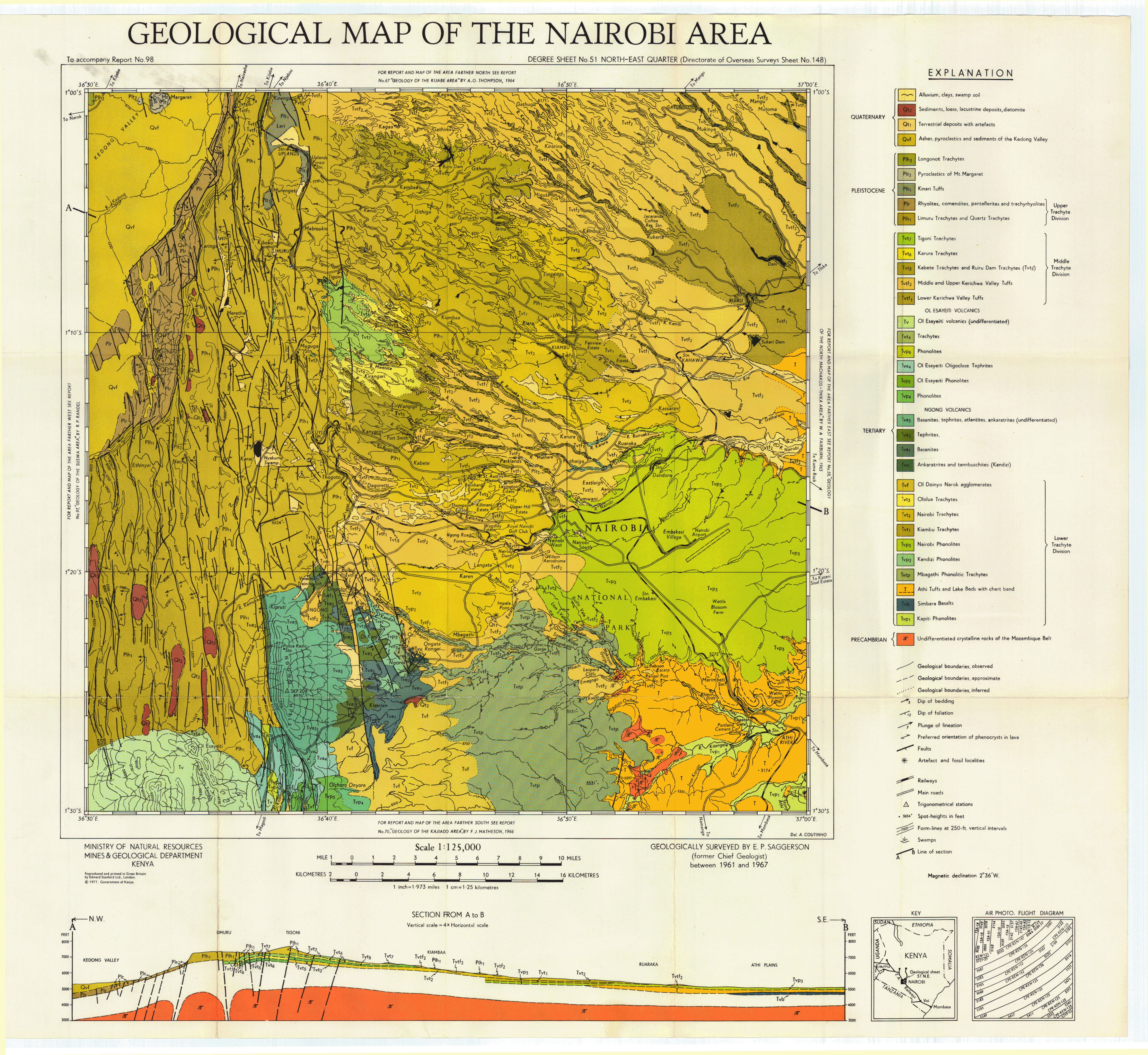
Geological map of the Naivasha area (43 SW)
Scale: 1:125000,
Sheet number/quarter: 43 SW
Year of publication: 1956
Filesize: 10,1 MB
Sheet number/quarter: 43 SW
Year of publication: 1956
Filesize: 10,1 MB
Map coordinates
Top left: 0° 30' S, 36° 00' E
Top right: 0° 30' S, 36° 30' E
Bottom left: 1° 00' S, 36° 30' E
Bottom right: 1° 00' S, 36° 00' E
Top left: 0° 30' S, 36° 00' E
Top right: 0° 30' S, 36° 30' E
Bottom left: 1° 00' S, 36° 30' E
Bottom right: 1° 00' S, 36° 00' E
Geological map of the Naivasha area (43 SW)
Scale: 1:125000,
Sheet number/quarter: 43 SW
Year of publication: 1963
Filesize: 9,8 MB
Sheet number/quarter: 43 SW
Year of publication: 1963
Filesize: 9,8 MB
Map coordinates
Top left: 0° 30' S, 36° 00' E
Top right: 0° 30' S, 36° 30' E
Bottom left: 1° 00' S, 36° 30' E
Bottom right: 1° 00' S, 36° 00' E
Top left: 0° 30' S, 36° 00' E
Top right: 0° 30' S, 36° 30' E
Bottom left: 1° 00' S, 36° 30' E
Bottom right: 1° 00' S, 36° 00' E
Geological map of the Naivasha area (44 SW)
Scale: 1:125000,
Sheet number/quarter: 44 SW
Year of publication: 1956
Filesize: 43,9 MB
Sheet number/quarter: 44 SW
Year of publication: 1956
Filesize: 43,9 MB
Map coordinates
Top left: 1° 30' S, 36° 00' E
Top right: 1° 30' S, 36° 30' E
Bottom left: 2° 00' S, 36° 30' E
Bottom right: 2° 00' S, 36° 00' E
Top left: 1° 30' S, 36° 00' E
Top right: 1° 30' S, 36° 30' E
Bottom left: 2° 00' S, 36° 30' E
Bottom right: 2° 00' S, 36° 00' E
Geological map of the Nakuru area (43 NW)
Scale: 1:125000,
Sheet number/quarter: 43 NW
Year of publication: 1966
Filesize: 3,7 MB
Sheet number/quarter: 43 NW
Year of publication: 1966
Filesize: 3,7 MB
Map coordinates
Top left: 0° 00' S, 36° 00' E
Top right: 0° 00' S, 36° 30' E
Bottom left: 0° 30' S, 36° 30' E
Bottom right: 0° 30' S, 36° 00' E
Top left: 0° 00' S, 36° 00' E
Top right: 0° 00' S, 36° 30' E
Bottom left: 0° 30' S, 36° 30' E
Bottom right: 0° 30' S, 36° 00' E

Geological map of the Nakuru area (43 NW)
Scale: 1:125000,
Sheet number/quarter: 43 NW
Year of publication: 1966
Filesize: 46,2 MB
Sheet number/quarter: 43 NW
Year of publication: 1966
Filesize: 46,2 MB
Map coordinates
Top left: 1° 00' S, 36° 00' E
Top right: 0° 00' S, 36° 30' E
Bottom left: 1° 30' S, 36° 30' E
Bottom right: 1° 30' S, 36° 00' E
Top left: 1° 00' S, 36° 00' E
Top right: 0° 00' S, 36° 30' E
Bottom left: 1° 30' S, 36° 30' E
Bottom right: 1° 30' S, 36° 00' E
Geology of the Nakuru-Thompson Falls -Lake Hannington area
Year of publication: 1967
Filesize: 19,5 MB
Filesize: 19,5 MB
Geological map of the Namanga - Bissel area (58 NE)
Scale: 1:125000,
Sheet number/quarter: 58 NE
Year of publication: 1955
Filesize: 8 MB
Sheet number/quarter: 58 NE
Year of publication: 1955
Filesize: 8 MB
Map coordinates
Top left: 2° 00' S, 36° 30' E
Top right: 2° 00' S, 37° 00' E
Bottom left: N/A
Bottom right: N/A
Top left: 2° 00' S, 36° 30' E
Top right: 2° 00' S, 37° 00' E
Bottom left: N/A
Bottom right: N/A

Geological map of the area between Nanyuki and Maralal
Scale: 1:250000,
Sheet number/quarter:
Year of publication: n/a
Filesize: 4,4 MB
Sheet number/quarter:
Year of publication: n/a
Filesize: 4,4 MB
Map coordinates
Top left: 1° 30' N, 36° 30' E
Top right: 1° 30' N, 37° 30' E
Bottom left: 0° 00' N, 37° 30' E
Bottom right: 0° 00' N, 36° 30' E
Top left: 1° 30' N, 36° 30' E
Top right: 1° 30' N, 37° 30' E
Bottom left: 0° 00' N, 37° 30' E
Bottom right: 0° 00' N, 36° 30' E
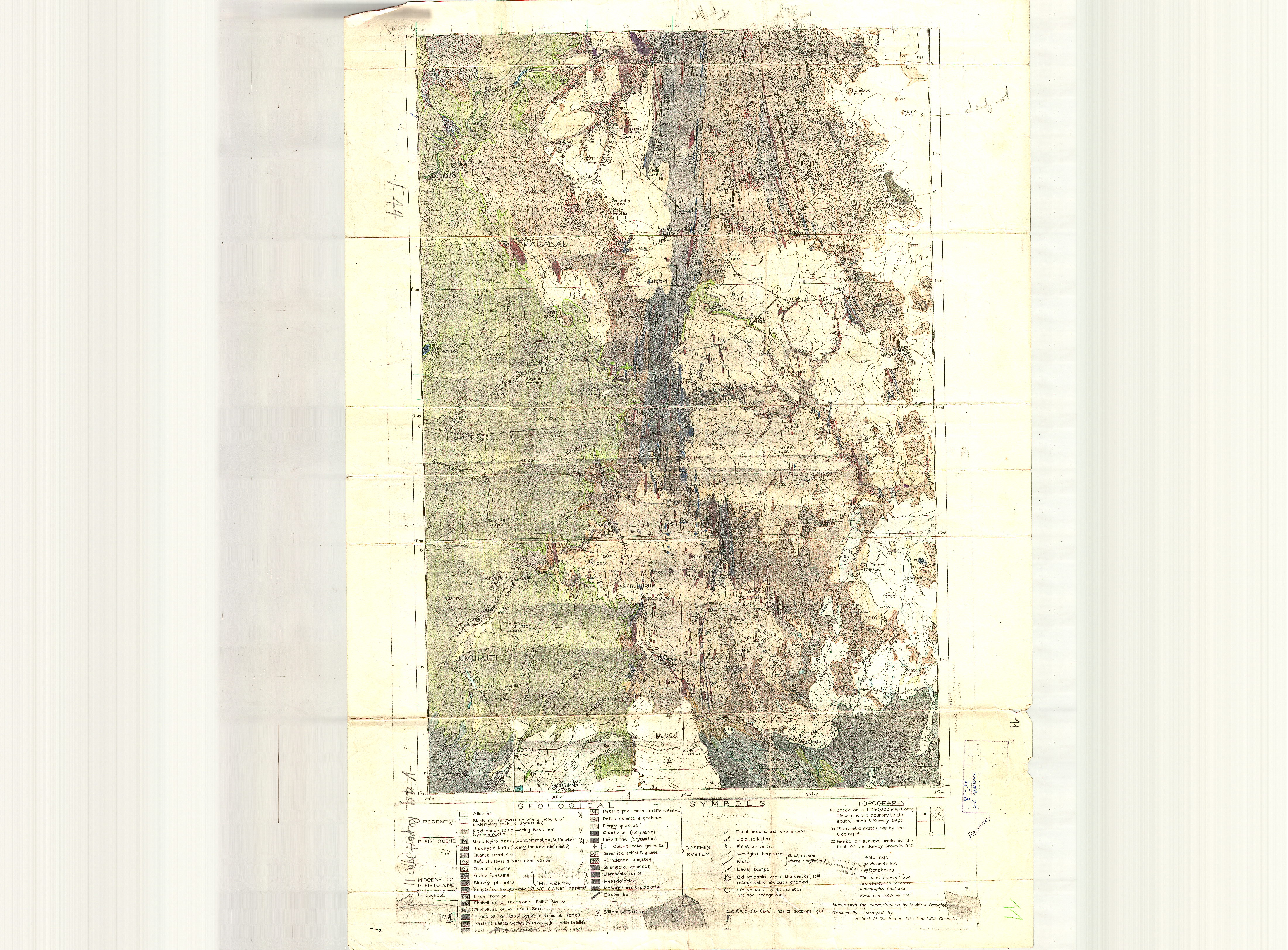
Nanyuki-Maralal - Physiographic sketch map of the Maralal area and districts to the west.
Year of publication: N/A
Filesize: 0,7 MB
Filesize: 0,7 MB
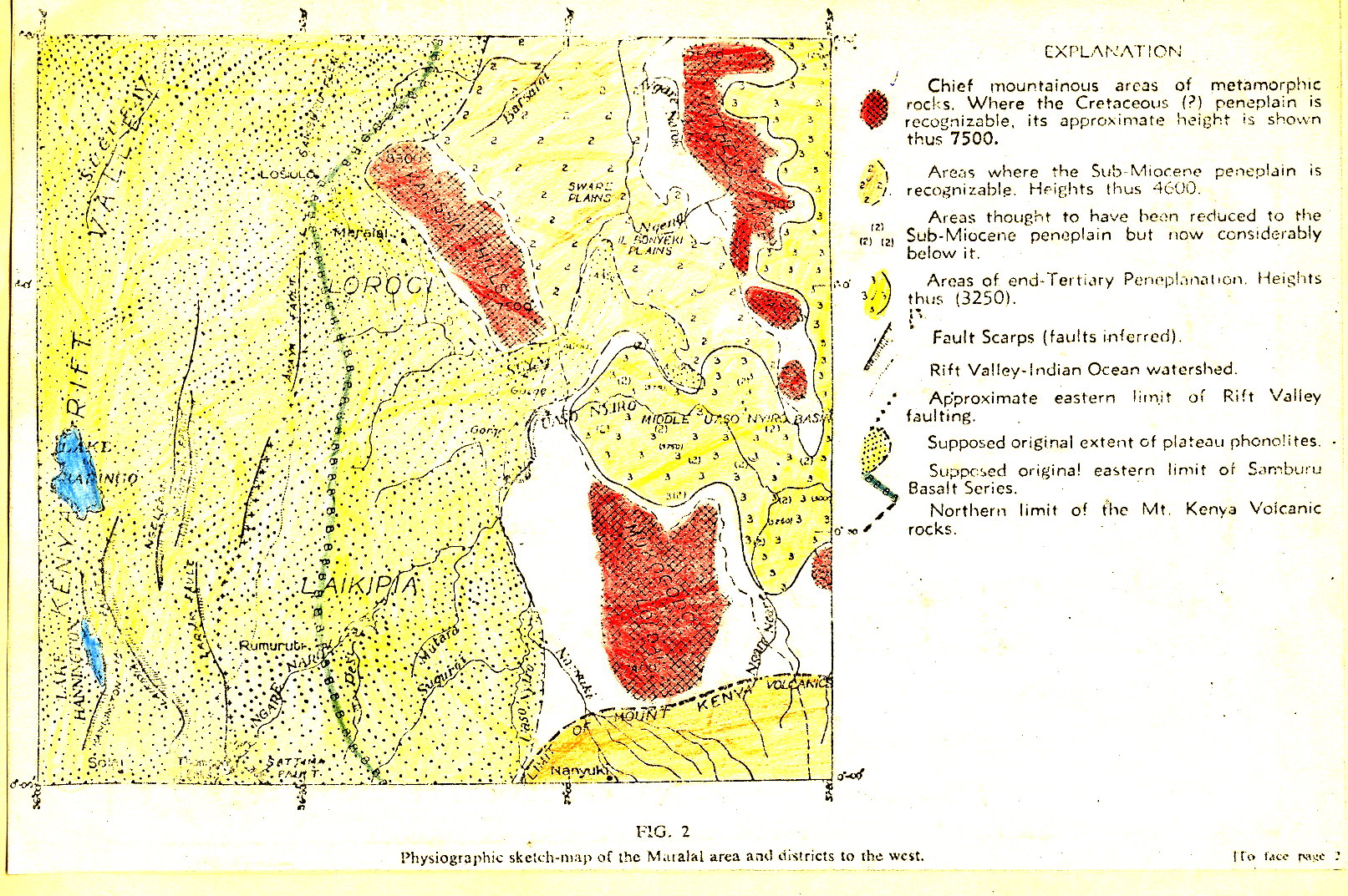

Geological map of the Narok area (50 NE)
Scale: 1:125000,
Sheet number/quarter: 50 NE
Year of publication: 1966
Filesize: 6,7 MB
Sheet number/quarter: 50 NE
Year of publication: 1966
Filesize: 6,7 MB
Map coordinates
Top left: 1° 00' S, 35° 30' E
Top right: 1° 00' S, 36° 00' E
Bottom left: 1° 30' S, 36° 00' E
Bottom right: 1° 30' S, 35° 30' E
Top left: 1° 00' S, 35° 30' E
Top right: 1° 00' S, 36° 00' E
Bottom left: 1° 30' S, 36° 00' E
Bottom right: 1° 30' S, 35° 30' E

Geological map of the Narok area (50 NE)
Scale: 1:125000,
Sheet number/quarter: 50 NE
Year of publication: 1966
Filesize: 2,6 MB
Sheet number/quarter: 50 NE
Year of publication: 1966
Filesize: 2,6 MB
Map coordinates
Top left: 1° 00' S, 35° 30' E
Top right: 1° 00' S, 36° 00' E
Bottom left: 1° 30' S, 36° 00' E
Bottom right: 1° 30' S, 35° 30' E
Top left: 1° 00' S, 35° 30' E
Top right: 1° 00' S, 36° 00' E
Bottom left: 1° 30' S, 36° 00' E
Bottom right: 1° 30' S, 35° 30' E

Geological map of the Ndeyini area (45 SE)
Scale: 1:125000,
Sheet number/quarter: 45 SE
Year of publication: 1964
Filesize: 6,3 MB
Sheet number/quarter: 45 SE
Year of publication: 1964
Filesize: 6,3 MB
Map coordinates
Top left: 0° 30' S, 38° 30' E
Top right: 0° 30' S, 39° 00' E
Bottom left: 1° 00' S, 39° 00' E
Bottom right: 1° 00' S, 38° 30' E
Top left: 0° 30' S, 38° 30' E
Top right: 0° 30' S, 39° 00' E
Bottom left: 1° 00' S, 39° 00' E
Bottom right: 1° 00' S, 38° 30' E

Geological map of the Ndiandaza area (60 NE)
Scale: 1:125000,
Sheet number/quarter: 60 NE
Year of publication: 1964
Filesize: 8,1 MB
Sheet number/quarter: 60 NE
Year of publication: 1964
Filesize: 8,1 MB
Map coordinates
Top left: 2° 00' S, 38° 30' E
Top right: 2° 00' S, 39° 00' E
Bottom left: 2° 30' S, 39° 00' E
Bottom right: 2° 30' S, 38° 30' E
Top left: 2° 00' S, 38° 30' E
Top right: 2° 00' S, 39° 00' E
Bottom left: 2° 30' S, 39° 00' E
Bottom right: 2° 30' S, 38° 30' E
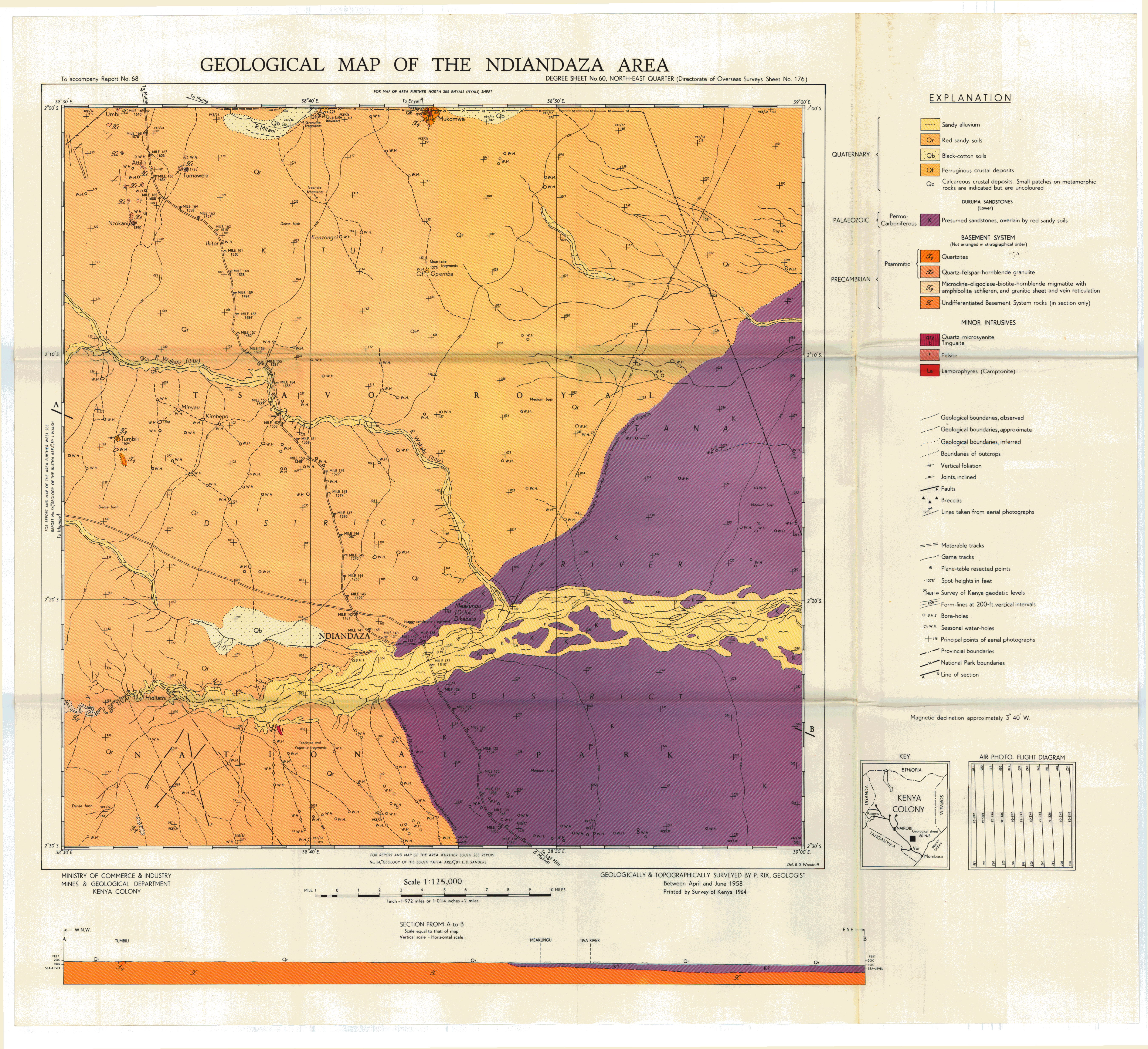

Provisional Geological Map of Nyeri County (43 NE)
Scale: 1:125000,
Sheet number/quarter: 43 NE
Year of publication: 1945
Filesize: 4 MB
Sheet number/quarter: 43 NE
Year of publication: 1945
Filesize: 4 MB
Map coordinates
Top left: 0° 00' S, 36° 30' E
Top right: 0° 00' S, 37° 00' E
Bottom left: 0° 30' S, 37° 00' E
Bottom right: 0° 30' S, 36° 30' E
Top left: 0° 00' S, 36° 30' E
Top right: 0° 00' S, 37° 00' E
Bottom left: 0° 30' S, 37° 00' E
Bottom right: 0° 30' S, 36° 30' E

Geological Map of the Rangwa Alkaline Igneous Complex
Scale: 1:15840,
Sheet number/quarter:
Year of publication: n/a
Filesize: 2,7 MB
Sheet number/quarter:
Year of publication: n/a
Filesize: 2,7 MB
Map coordinates
Top left: N/A
Top right: N/A
Bottom left: N/A
Bottom right: N/A
Top left: N/A
Top right: N/A
Bottom left: N/A
Bottom right: N/A

Geological map of the Ruri Hills, Tuige and Sokolo
Scale: 1:21120,
Sheet number/quarter:
Year of publication: n/a
Filesize: 47,9 MB
Sheet number/quarter:
Year of publication: n/a
Filesize: 47,9 MB
Map coordinates
Top left: N/A
Top right: N/A
Bottom left: N/A
Bottom right: N/A
Top left: N/A
Top right: N/A
Bottom left: N/A
Bottom right: N/A
Geological map of the Ruri Hills, Tuige and Sokolo (n/a)
Scale: 1:21120,
Sheet number/quarter: n/a
Year of publication: n/a
Filesize: 2,1 MB
Sheet number/quarter: n/a
Year of publication: n/a
Filesize: 2,1 MB
Map coordinates
Top left: N/A
Top right: N/A
Bottom left: N/A
Bottom right: N/A
Top left: N/A
Top right: N/A
Bottom left: N/A
Bottom right: N/A
Sabarei (Parts of Degree square 3 and 4)
Scale: 1:250000,
Sheet number/quarter: Parts of Degree square 3 and 4
Year of publication: 1987
Filesize: 6,6 MB
Sheet number/quarter: Parts of Degree square 3 and 4
Year of publication: 1987
Filesize: 6,6 MB
Map coordinates
Top left: 4° 30' N, 36° 00' E
Top right: 4° 30' N, 37° 40' E
Bottom left: 4° 00' N, 37° 40' E
Bottom right: 4° 00' N, 36° 00' E
Top left: 4° 30' N, 36° 00' E
Top right: 4° 30' N, 37° 40' E
Bottom left: 4° 00' N, 37° 40' E
Bottom right: 4° 00' N, 36° 00' E

Sekerr - Sketch showing profiles of erosion surfaces at the Maral-Argut escarpment, looking from the West.
Year of publication: N/A
Filesize: 0,3 MB
Filesize: 0,3 MB

Geological map of the Sekerr area (26 NW)
Scale: 1:125000,
Sheet number/quarter: 26 NW
Year of publication: 1964
Filesize: 7,7 MB
Sheet number/quarter: 26 NW
Year of publication: 1964
Filesize: 7,7 MB
Map coordinates
Top left: 2° 00' N, 35° 00' E
Top right: 2° 00' N, 35° 30' E
Bottom left: 1° 30' N, 35° 30' E
Bottom right: 1° 30' N, 35° 00' E
Top left: 2° 00' N, 35° 00' E
Top right: 2° 00' N, 35° 30' E
Bottom left: 1° 30' N, 35° 30' E
Bottom right: 1° 30' N, 35° 00' E

Geological map of the Sekerr area (26 NW)
Scale: 1:125000,
Sheet number/quarter: 26 NW
Year of publication: 1964
Filesize: 3,1 MB
Sheet number/quarter: 26 NW
Year of publication: 1964
Filesize: 3,1 MB
Map coordinates
Top left: 2° 00' N, 35° 00' E
Top right: 2° 00' N, 35° 30' E
Bottom left: 1° 30' N, 35° 50' E
Bottom right: 1° 30' N, 35° 00' E
Top left: 2° 00' N, 35° 00' E
Top right: 2° 00' N, 35° 30' E
Bottom left: 1° 30' N, 35° 50' E
Bottom right: 1° 30' N, 35° 00' E
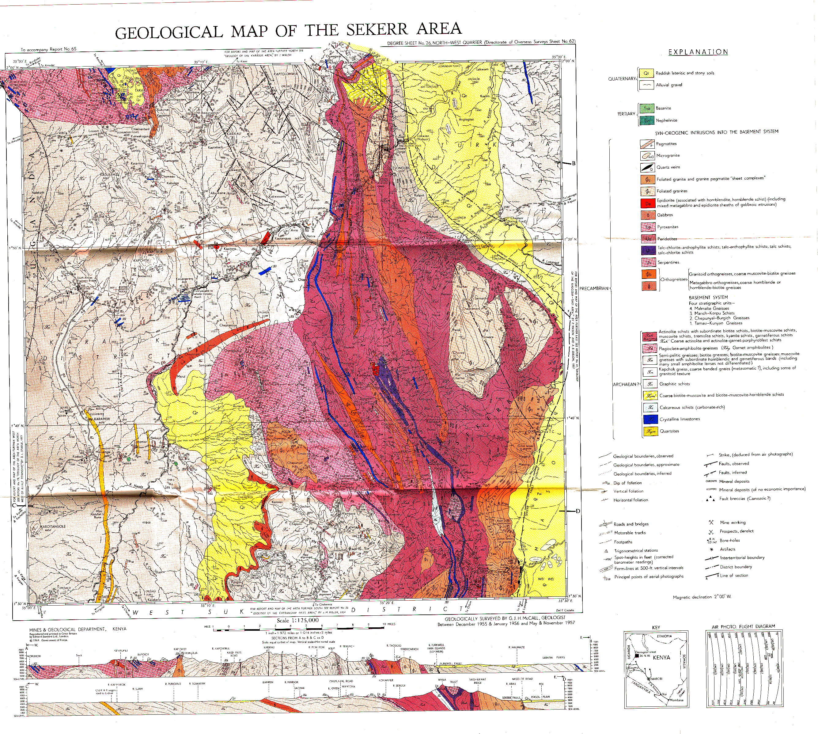
Structural map of the Sekerr area
Scale: 1:125000,
Sheet number/quarter:
Year of publication: n/a
Filesize: 1,1 MB
Sheet number/quarter:
Year of publication: n/a
Filesize: 1,1 MB
Map coordinates
Top left: 2° 00' N, 35° 00' E
Top right: 2° 00' N, 35° 30' E
Bottom left: 1° 30' N, 35° 50' E
Bottom right: 1° 30' N, 35° 00' E
Top left: 2° 00' N, 35° 00' E
Top right: 2° 00' N, 35° 30' E
Bottom left: 1° 30' N, 35° 50' E
Bottom right: 1° 30' N, 35° 00' E

Geology and mineral resources of the Seychelles Archipelago area
Year of publication: 1963
Filesize: 21,8 MB
Filesize: 21,8 MB
Geological map of the Sianna area (50 SW)
Scale: 1:125000,
Sheet number/quarter: 50 SW
Year of publication: 1964
Filesize: 4,1 MB
Sheet number/quarter: 50 SW
Year of publication: 1964
Filesize: 4,1 MB
Map coordinates
Top left: 1° 30' S, 35° 00' E
Top right: 1° 30' S, 35° 30' E
Bottom left: 1° 55' S, 35° 00' E
Bottom right: 1° 55' S, 35° 30' E
Top left: 1° 30' S, 35° 00' E
Top right: 1° 30' S, 35° 30' E
Bottom left: 1° 55' S, 35° 00' E
Bottom right: 1° 55' S, 35° 30' E

Geological map of the Sianna area (50 SW)
Scale: 1:125000,
Sheet number/quarter: 50 SW
Year of publication: 1964
Filesize: 1,3 MB
Sheet number/quarter: 50 SW
Year of publication: 1964
Filesize: 1,3 MB
Map coordinates
Top left: 1° 30' S, 35° 00' E
Top right: 1° 30' S, 35° 30' E
Bottom left: 1° 55' S, 35° 30' E
Bottom right: 1° 55' S, 35° 00' E
Top left: 1° 30' S, 35° 00' E
Top right: 1° 30' S, 35° 30' E
Bottom left: 1° 55' S, 35° 30' E
Bottom right: 1° 55' S, 35° 00' E
Geological map of the Simba - Kibwezi area (59 NE)
Scale: 1:125000,
Sheet number/quarter: 59 NE
Year of publication: Between 1956 and 1957
Filesize: 7,8 MB
Sheet number/quarter: 59 NE
Year of publication: Between 1956 and 1957
Filesize: 7,8 MB
Map coordinates
Top left: 2° 00' S, 37° 30' E
Top right: 2° 00' S, 38° 00' E
Bottom left: 2° 30' S, 38° 00' E
Bottom right: 2° 30' S, 37° 30' E
Top left: 2° 00' S, 37° 30' E
Top right: 2° 00' S, 38° 00' E
Bottom left: 2° 30' S, 38° 00' E
Bottom right: 2° 30' S, 37° 30' E
Geological map of Sotik District (42 SW)
Scale: 1:125000,
Sheet number/quarter: 42 SW
Year of publication: Between 1946 and 1947
Filesize: 45,6 MB
Sheet number/quarter: 42 SW
Year of publication: Between 1946 and 1947
Filesize: 45,6 MB
Map coordinates
Top left: 0° 30' S, 35° 00' E
Top right: 3° 00' S, 38° 00' E
Bottom left: 1° 00' S, 35° 30' E
Bottom right: 1° 00' S, 35° 00' E
Top left: 0° 30' S, 35° 00' E
Top right: 3° 00' S, 38° 00' E
Bottom left: 1° 00' S, 35° 30' E
Bottom right: 1° 00' S, 35° 00' E
Geological map of the Sultan Hamud area (59 NW)
Scale: 1:125000,
Sheet number/quarter: 59 NW
Year of publication: 1954
Filesize: 7 MB
Sheet number/quarter: 59 NW
Year of publication: 1954
Filesize: 7 MB
Map coordinates
Top left: 2° 00' S, 37° 00' E
Top right: 2° 00' S, 37° 30' E
Bottom left: 2° 30' S, 37° 30' E
Bottom right: 2° 30' S, 37° 00' E
Top left: 2° 00' S, 37° 00' E
Top right: 2° 00' S, 37° 30' E
Bottom left: 2° 30' S, 37° 30' E
Bottom right: 2° 30' S, 37° 00' E

Geological map of the Sultan Hamud area (59 NW)
Scale: 1:125000,
Sheet number/quarter: 59 NW
Year of publication: 1954
Filesize: 37,7 MB
Sheet number/quarter: 59 NW
Year of publication: 1954
Filesize: 37,7 MB
Map coordinates
Top left: 2° 00' S, 37° 00' E
Top right: 2° 00' S, 37° 30' E
Bottom left: 2° 30' S, 37° 30' E
Bottom right: 2° 30' S, 37° 00' E
Top left: 2° 00' S, 37° 00' E
Top right: 2° 00' S, 37° 30' E
Bottom left: 2° 30' S, 37° 30' E
Bottom right: 2° 30' S, 37° 00' E
Geological map of the Suswa area (51NW)
Scale: 1:125000,
Sheet number/quarter: 51NW
Year of publication: 1970
Filesize: 6,6 MB
Sheet number/quarter: 51NW
Year of publication: 1970
Filesize: 6,6 MB
Map coordinates
Top left: 1° 00' S, 36° 00' E
Top right: 1° 00' S, 36° 30' E
Bottom left: 1° 30' S, 36° 30' E
Bottom right: 1° 30' S, 36° 00' E
Top left: 1° 00' S, 36° 00' E
Top right: 1° 00' S, 36° 30' E
Bottom left: 1° 30' S, 36° 30' E
Bottom right: 1° 30' S, 36° 00' E

Geological map of the Suswa area (52NW)
Scale: 1:125000,
Sheet number/quarter: 52NW
Year of publication: 1970
Filesize: 43,5 MB
Sheet number/quarter: 52NW
Year of publication: 1970
Filesize: 43,5 MB
Map coordinates
Top left: 1° 00' S, 36° 00' E
Top right: 1° 00' S, 36° 30' E
Bottom left: 1° 30' S, 36° 30' E
Bottom right: 1° 30' S, 36° 00' E
Top left: 1° 00' S, 36° 00' E
Top right: 1° 00' S, 36° 30' E
Bottom left: 1° 30' S, 36° 30' E
Bottom right: 1° 30' S, 36° 00' E


Geological map of the area South of the Taita Hills (65 SW,65 NW,68 NW)
Scale: 1:125000,
Sheet number/quarter: 65 SW,65 NW,68 NW
Year of publication: 1955
Filesize: 7 MB
Sheet number/quarter: 65 SW,65 NW,68 NW
Year of publication: 1955
Filesize: 7 MB
Map coordinates
Top left: N/A
Top right: N/A
Bottom left: N/A
Bottom right: N/A
Top left: N/A
Top right: N/A
Bottom left: N/A
Bottom right: N/A
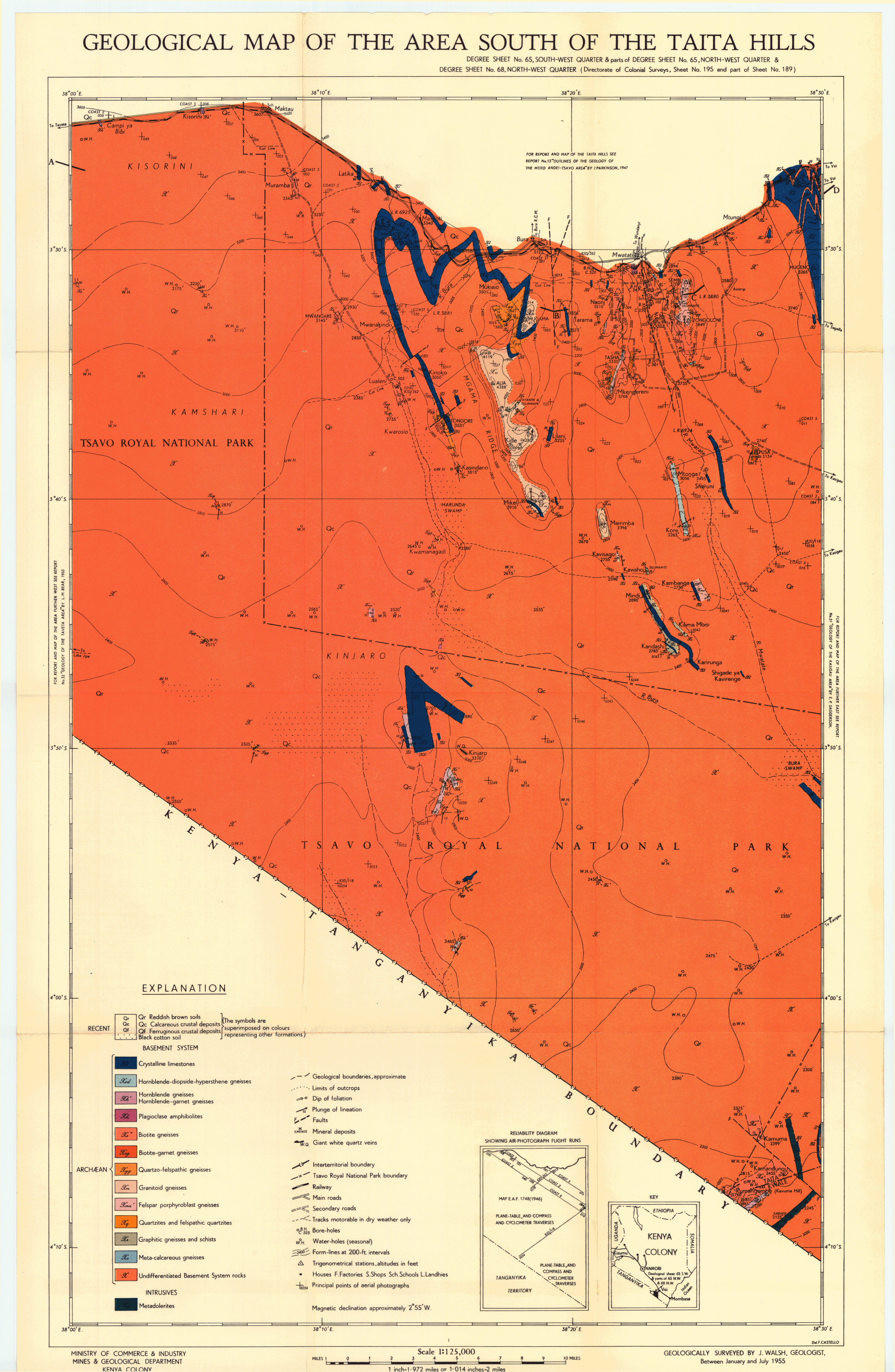
Geological map of the area South of the Taita Hills (65 SW parts of 65 NW and 68 NW)
Scale: 1:125000,
Sheet number/quarter: 65 SW parts of 65 NW and 68 NW
Year of publication: n/a
Filesize: 2,9 MB
Sheet number/quarter: 65 SW parts of 65 NW and 68 NW
Year of publication: n/a
Filesize: 2,9 MB
Map coordinates
Top left: N/A
Top right: N/A
Bottom left: N/A
Bottom right: N/A
Top left: N/A
Top right: N/A
Bottom left: N/A
Bottom right: N/A

Geological map of the Taita Hills (65 SW,65 NW,68 NW)
Scale: 1:125000,
Sheet number/quarter: 65 SW,65 NW,68 NW
Year of publication: 1978
Filesize: 11,1 MB
Sheet number/quarter: 65 SW,65 NW,68 NW
Year of publication: 1978
Filesize: 11,1 MB
Map coordinates
Top left: 3° 15' S, 38° 15' E
Top right: 3° 15' S, 38° 30' E
Bottom left: 3° 30' S, 38° 30' E
Bottom right: 3° 30' S, 38° 15' E
Top left: 3° 15' S, 38° 15' E
Top right: 3° 15' S, 38° 30' E
Bottom left: 3° 30' S, 38° 30' E
Bottom right: 3° 30' S, 38° 15' E

Geological map of the Takabba area (15 SW)
Scale: 1:125000,
Sheet number/quarter: 15 SW
Year of publication: 1953
Filesize: 7,2 MB
Sheet number/quarter: 15 SW
Year of publication: 1953
Filesize: 7,2 MB
Map coordinates
Top left: 3° 30' N, 40° 00' E
Top right: 3° 30' N, 40° 30' E
Bottom left: 3° 00' N, 40° 30' E
Bottom right: 3° 00' N, 40° 00' E
Top left: 3° 30' N, 40° 00' E
Top right: 3° 30' N, 40° 30' E
Bottom left: 3° 00' N, 40° 30' E
Bottom right: 3° 00' N, 40° 00' E
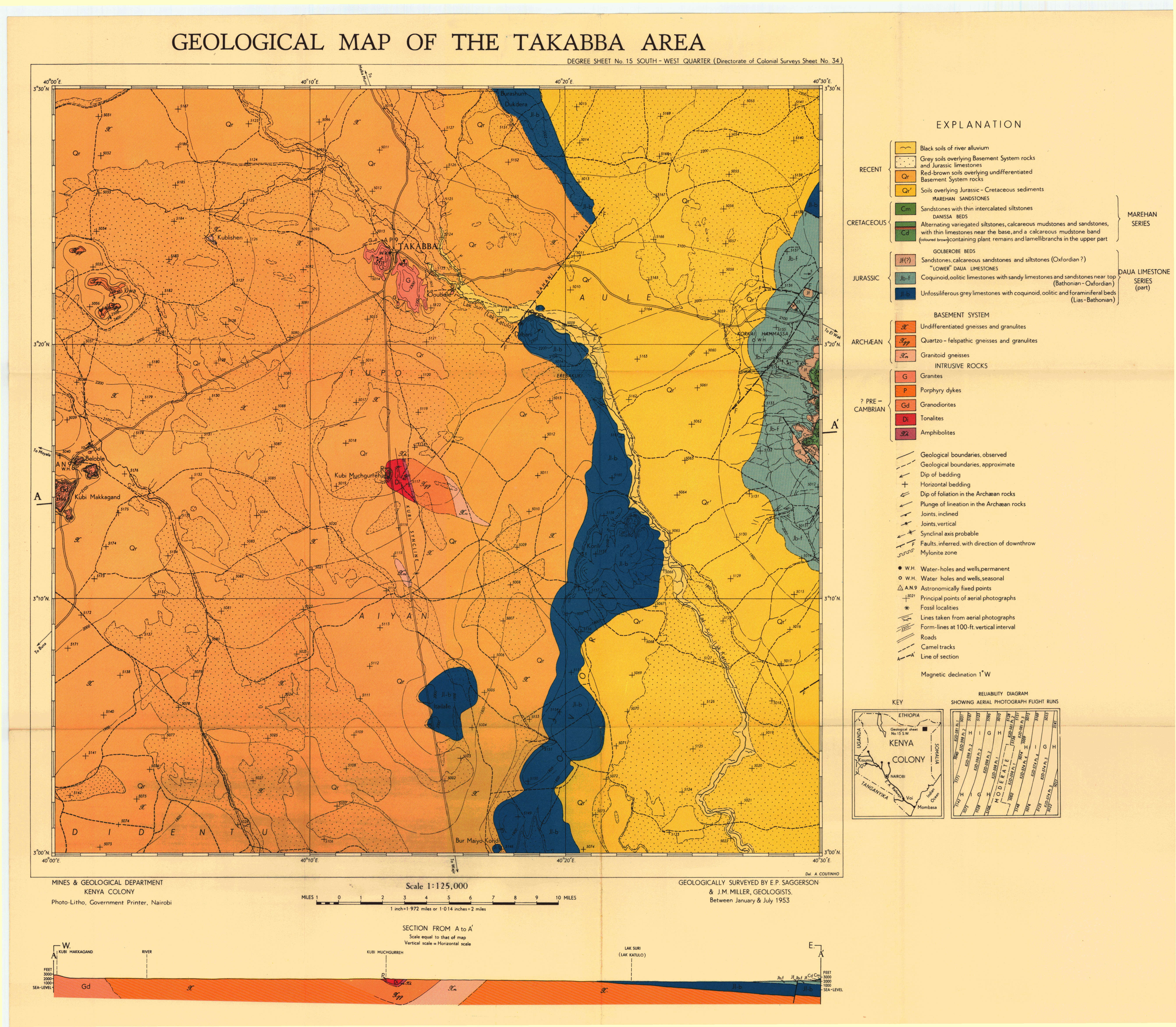
Geological map of the Tarbaj area (23 SW)
Scale: 1:125000,
Sheet number/quarter: 23 SW
Year of publication: 1954
Filesize: 5,6 MB
Sheet number/quarter: 23 SW
Year of publication: 1954
Filesize: 5,6 MB
Map coordinates
Top left: 2° 30' N, 40° 00' E
Top right: 2° 30' N, 40° 30' E
Bottom left: 2° 00' N, 40° 30' E
Bottom right: 2° 00' N, 40° 00' E
Top left: 2° 30' N, 40° 00' E
Top right: 2° 30' N, 40° 30' E
Bottom left: 2° 00' N, 40° 30' E
Bottom right: 2° 00' N, 40° 00' E
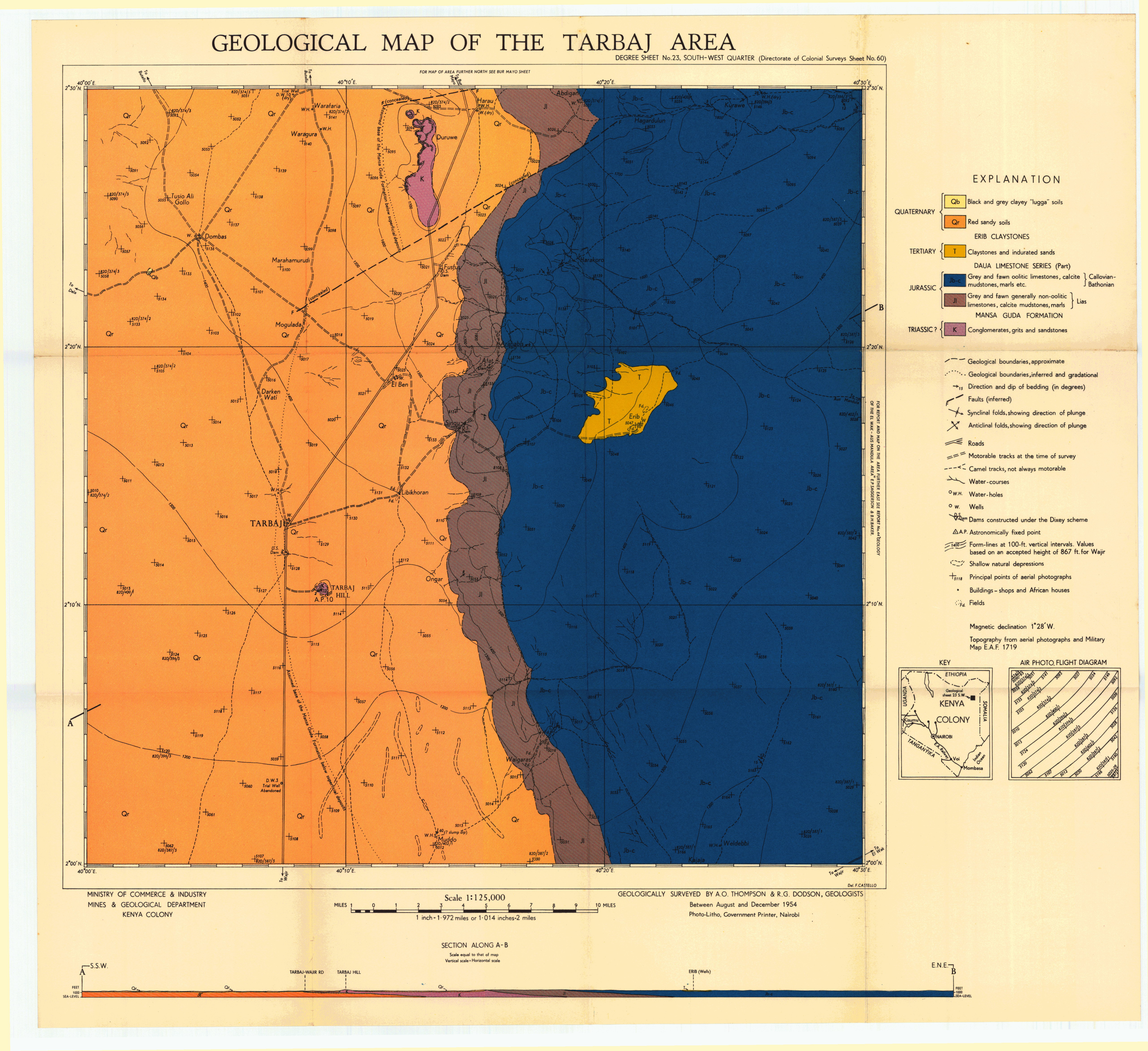
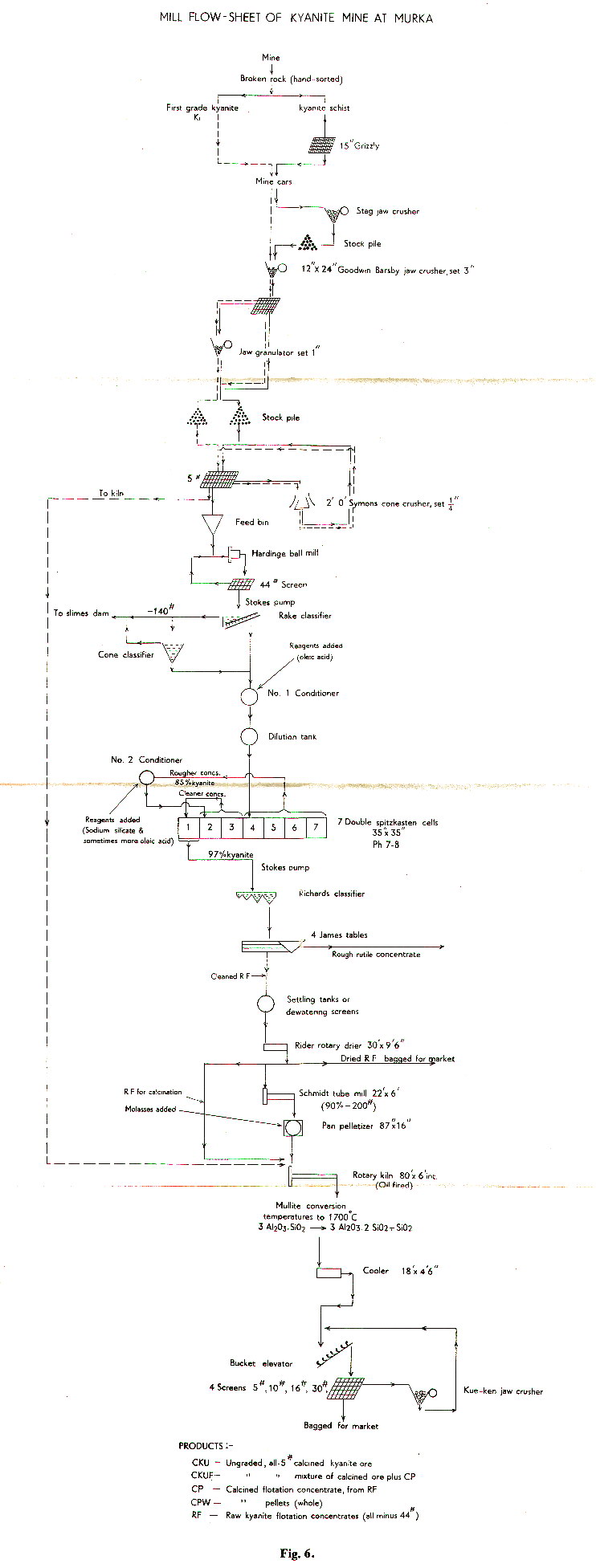
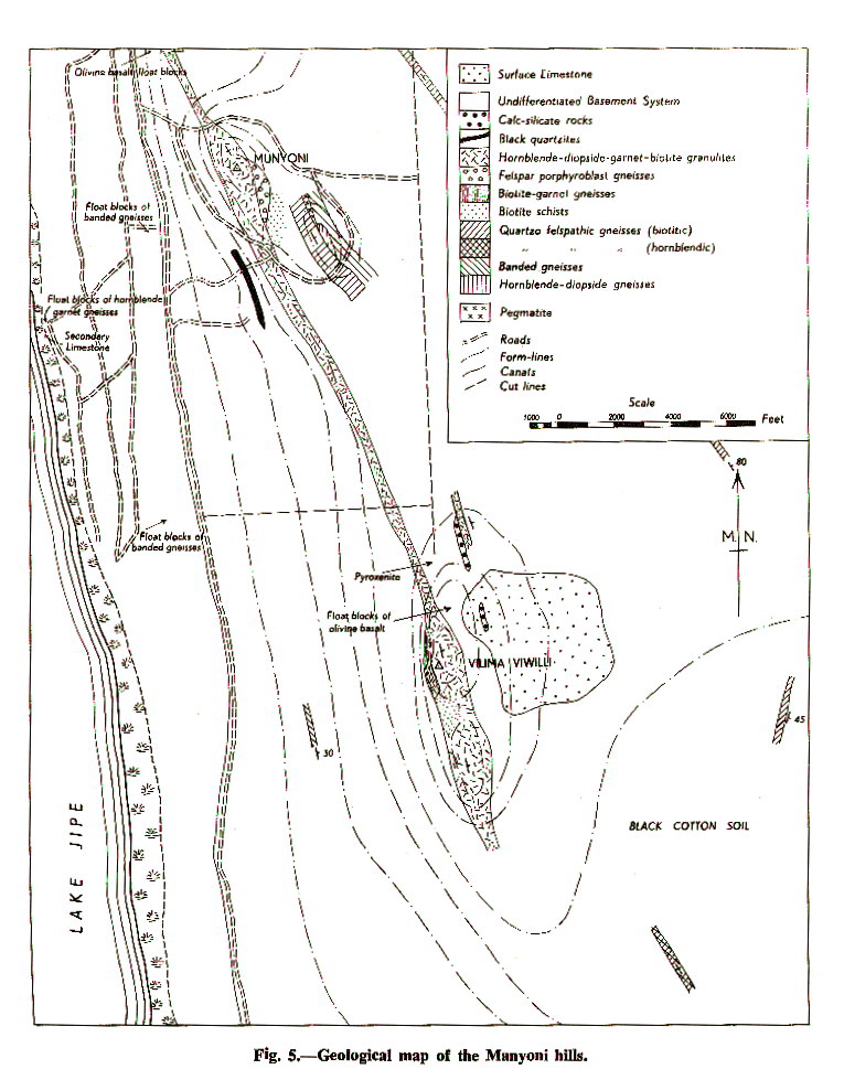

Geological map of the Taveta area (64 NE)
Scale: 1:125000,
Sheet number/quarter: 64 NE
Year of publication: 1954
Filesize: 1,8 MB
Sheet number/quarter: 64 NE
Year of publication: 1954
Filesize: 1,8 MB
Map coordinates
Top left: N/A
Top right: 3° 00' S, 38° 00' E
Bottom left: 3° 30' S, 38° 00' E
Bottom right: N/A
Top left: N/A
Top right: 3° 00' S, 38° 00' E
Bottom left: 3° 30' S, 38° 00' E
Bottom right: N/A

Geological map of the Taveta area (64 NE)
Scale: 1:125000,
Sheet number/quarter: 64 NE
Year of publication: 1954
Filesize: 5 MB
Sheet number/quarter: 64 NE
Year of publication: 1954
Filesize: 5 MB
Map coordinates
Top left: N/A
Top right: 3° 00' S, 38° 00' E
Bottom left: 3° 30' S, 38° 00' E
Bottom right: N/A
Top left: N/A
Top right: 3° 00' S, 38° 00' E
Bottom left: 3° 30' S, 38° 00' E
Bottom right: N/A
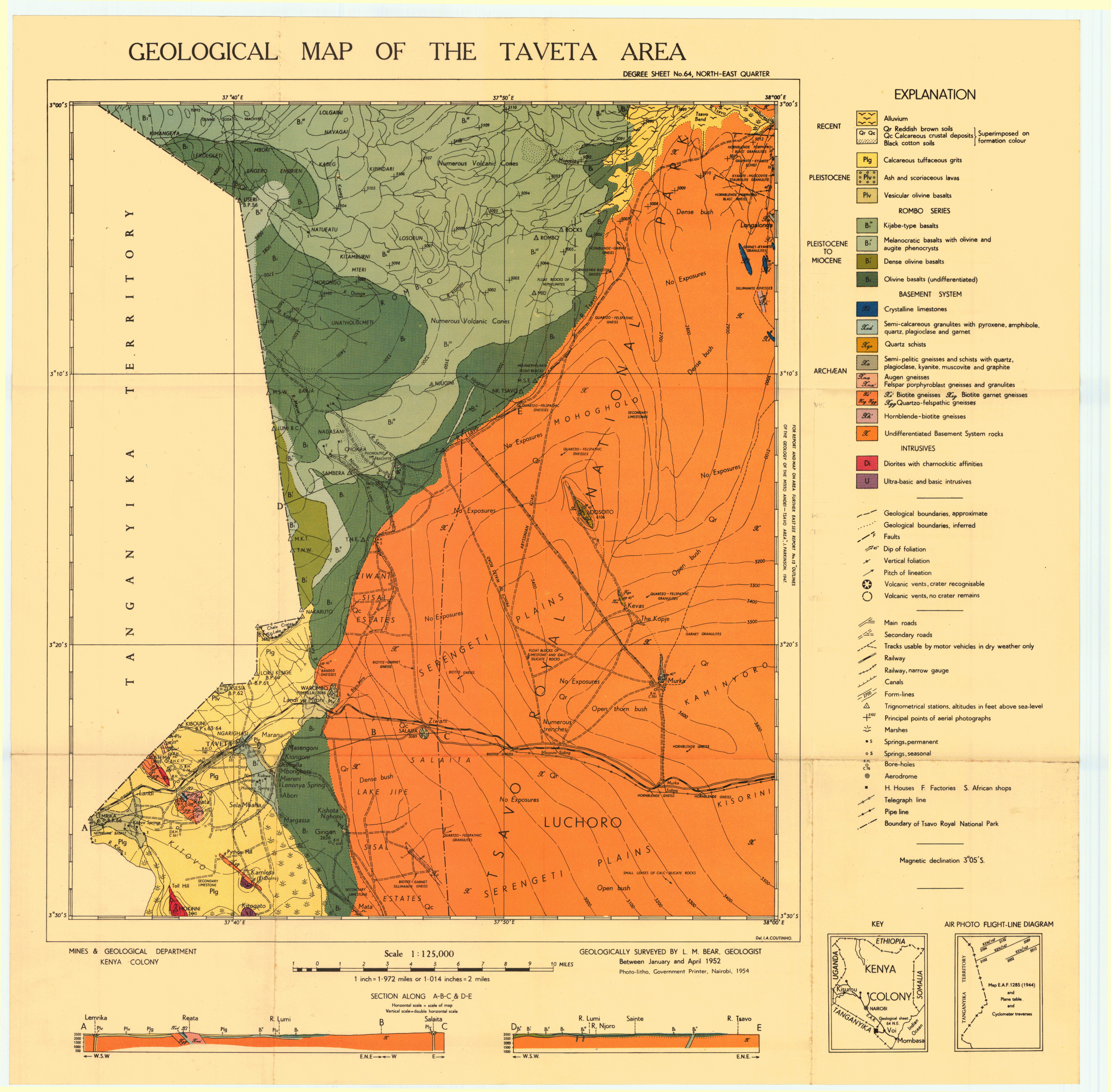
Geological map of the Taveta area (64 NE)
Scale: 1:125000,
Sheet number/quarter: 64 NE
Year of publication: 1954
Filesize: 32,7 MB
Sheet number/quarter: 64 NE
Year of publication: 1954
Filesize: 32,7 MB
Map coordinates
Top left: N/A
Top right: 3° 00' S, 38° 00' E
Bottom left: 3° 30' S, 38° 00' E
Bottom right: N/A
Top left: N/A
Top right: 3° 00' S, 38° 00' E
Bottom left: 3° 30' S, 38° 00' E
Bottom right: N/A

Geological map of the Thompson's Falls - Lake Hannington area (35 SW)
Scale: 1:125000,
Sheet number/quarter: 35 SW
Year of publication: 1966
Filesize: 3,4 MB
Sheet number/quarter: 35 SW
Year of publication: 1966
Filesize: 3,4 MB
Map coordinates
Top left: 0° 30' N, 36° 00' E
Top right: 0° 30' N, 36° 30' E
Bottom left: 0° 00' N, 36° 30' E
Bottom right: 0° 00' N, 36° 00' E
Top left: 0° 30' N, 36° 00' E
Top right: 0° 30' N, 36° 30' E
Bottom left: 0° 00' N, 36° 30' E
Bottom right: 0° 00' N, 36° 00' E
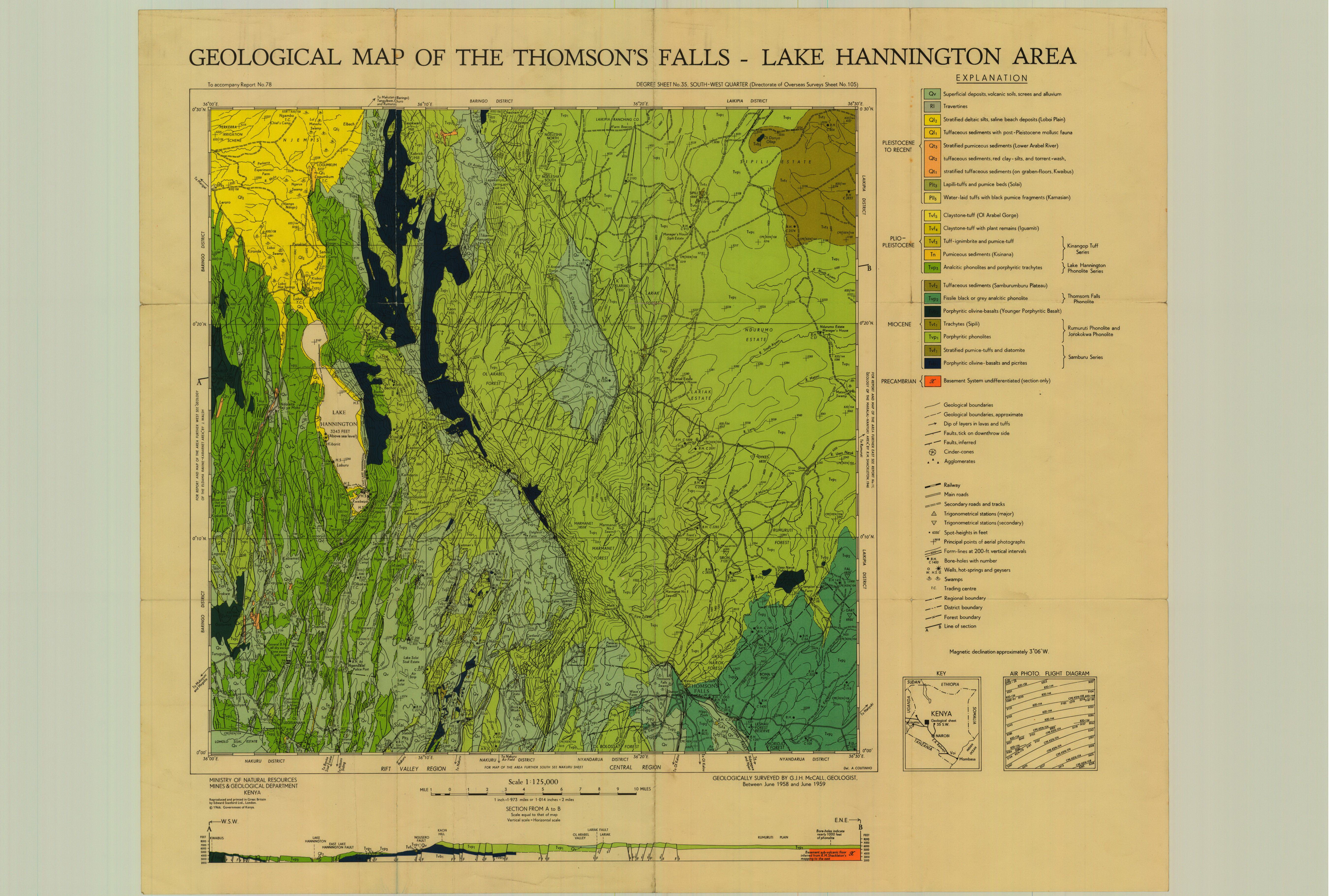
Geological map of the Thompson's Falls - Lake Hannington area (35 SW)
Scale: 1:125000,
Sheet number/quarter: 35 SW
Year of publication: 1966
Filesize: 43,4 MB
Sheet number/quarter: 35 SW
Year of publication: 1966
Filesize: 43,4 MB
Map coordinates
Top left: 0° 30' S, 36° 00' E
Top right: 0° 30' N, 36° 30' E
Bottom left: 0° 00' S, 36° 30' E
Bottom right: 0° 00' S, 36° 00' E
Top left: 0° 30' S, 36° 00' E
Top right: 0° 30' N, 36° 30' E
Bottom left: 0° 00' S, 36° 30' E
Bottom right: 0° 00' S, 36° 00' E

Geological map of the Thompson's Falls - Lake Hannington area (35 SW)
Scale: 1:125000,
Sheet number/quarter: 35 SW
Year of publication:
Filesize: 7,8 MB
Sheet number/quarter: 35 SW
Year of publication:
Filesize: 7,8 MB
Map coordinates
Top left: 0° 30' S, 36° 00' E
Top right: 0° 30' N, 36° 30' E
Bottom left: 0° 00' S, 36° 30' E
Bottom right: 0° 00' S, 36° 00' E
Top left: 0° 30' S, 36° 00' E
Top right: 0° 30' N, 36° 30' E
Bottom left: 0° 00' S, 36° 30' E
Bottom right: 0° 00' S, 36° 00' E

Geological map of the Tiati area (26 SE)
Scale: 1:125000,
Sheet number/quarter: 26 SE
Year of publication: 1952
Filesize: 7,3 MB
Sheet number/quarter: 26 SE
Year of publication: 1952
Filesize: 7,3 MB
Map coordinates
Top left: 1° 30' N, 36° 00' E
Top right: 1° 00' N, 36° 00' E
Bottom left: 1° 30' N, 35° 30' E
Bottom right: 1° 00' N, 35° 30' E
Top left: 1° 30' N, 36° 00' E
Top right: 1° 00' N, 36° 00' E
Bottom left: 1° 30' N, 35° 30' E
Bottom right: 1° 00' N, 35° 30' E
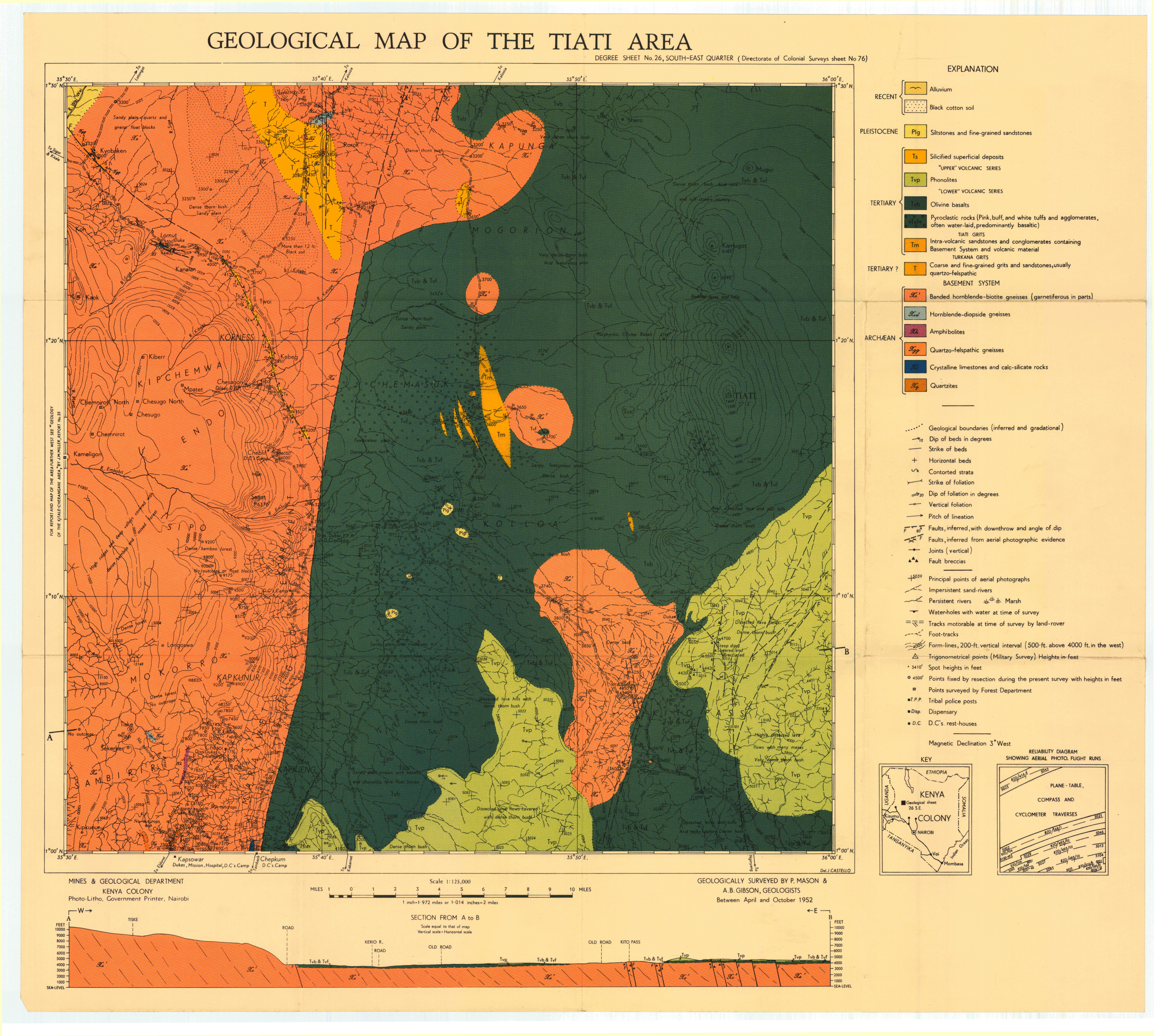
Geological map of the Northern Tugen Hills (34 NE)
Scale: 1:125000,
Sheet number/quarter: 34 NE
Year of publication: Between 1965 and 1970
Filesize: 2,9 MB
Sheet number/quarter: 34 NE
Year of publication: Between 1965 and 1970
Filesize: 2,9 MB
Map coordinates
Top left: 1° 00' N, 35° 30' E
Top right: 1° 00' N, 36° 00' E
Bottom left: 0° 30' N, 36° 00' E
Bottom right: 0° 30' N, 35° 30' E
Top left: 1° 00' N, 35° 30' E
Top right: 1° 00' N, 36° 00' E
Bottom left: 0° 30' N, 36° 00' E
Bottom right: 0° 30' N, 35° 30' E

Geological map of the Northern Turkana area (10)
Scale: 1:500000,
Sheet number/quarter: 10
Year of publication: 1966
Filesize: 5,6 MB
Sheet number/quarter: 10
Year of publication: 1966
Filesize: 5,6 MB
Map coordinates
Top left: 4° 40' N, 34° 00' E
Top right: 4° 40' N, 36° 40' E
Bottom left: 3° 00' N, 36° 40' E
Bottom right: 3° 00' N, 34° 00' E
Top left: 4° 40' N, 34° 00' E
Top right: 4° 40' N, 36° 40' E
Bottom left: 3° 00' N, 36° 40' E
Bottom right: 3° 00' N, 34° 00' E
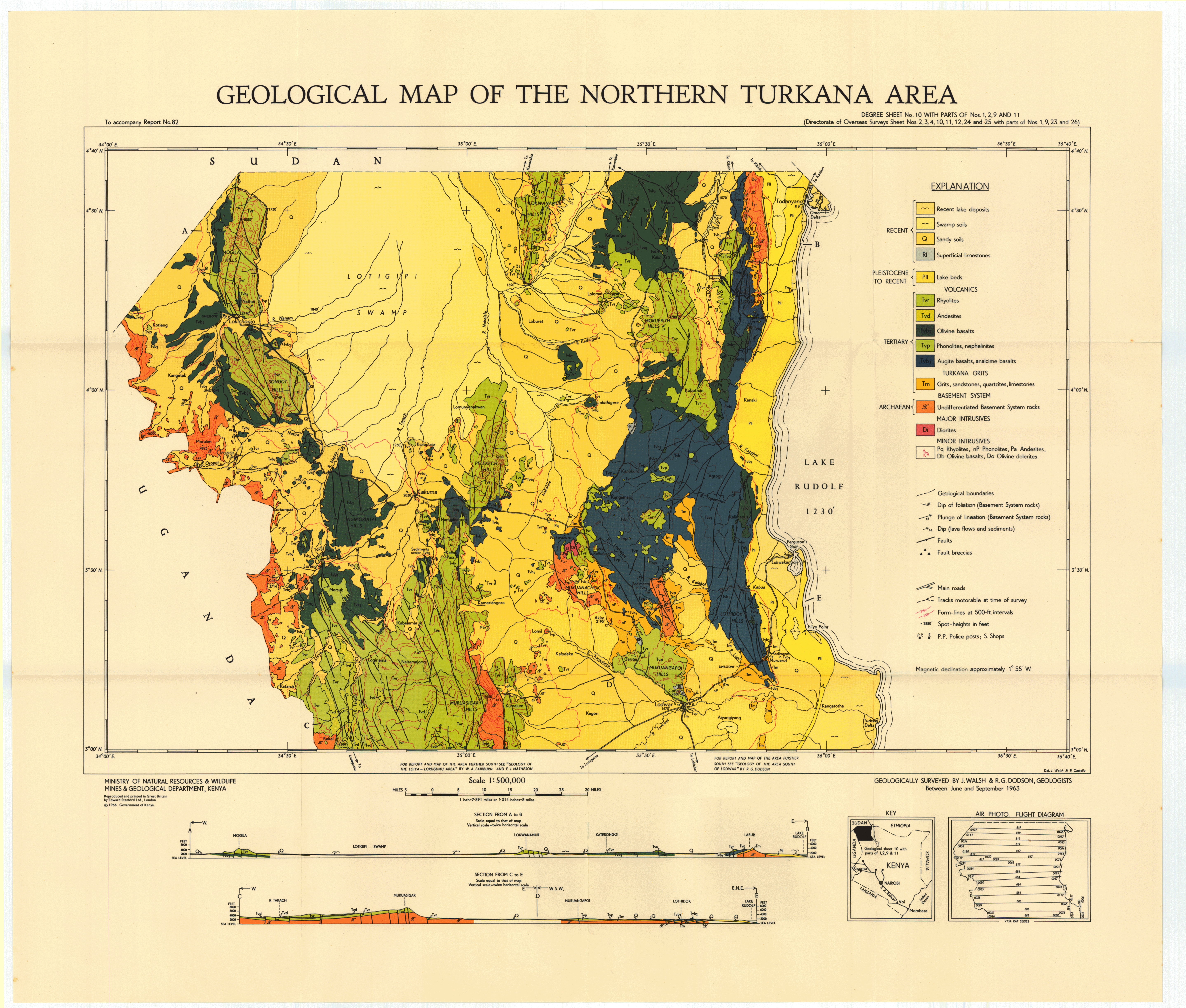
Geological map of the Northern Turkana area (10)
Scale: 1:500000,
Sheet number/quarter: 10
Year of publication: 1966
Filesize: 4,8 MB
Sheet number/quarter: 10
Year of publication: 1966
Filesize: 4,8 MB
Map coordinates
Top left: 4° 40' N, 34° 00' E
Top right: 4° 40' N, 36° 40' E
Bottom left: 3° 00' N, 36° 40' E
Bottom right: 3° 00' N, 34° 00' E
Top left: 4° 40' N, 34° 00' E
Top right: 4° 40' N, 36° 40' E
Bottom left: 3° 00' N, 36° 40' E
Bottom right: 3° 00' N, 34° 00' E

Geological map of the Nothern Turkana area (10 with parts of Nos. 1,2,9 and 11)
Scale: 1:500000,
Sheet number/quarter: 10 with parts of Nos. 1,2,9 and 11
Year of publication: 1966
Filesize: 2,2 MB
Sheet number/quarter: 10 with parts of Nos. 1,2,9 and 11
Year of publication: 1966
Filesize: 2,2 MB
Map coordinates
Top left: 4° 40' N, 34° 00' E
Top right: 4° 40' N, 36° 40' E
Bottom left: 3° 00' N, 36° 40' E
Bottom right: 3° 00' N, 34° 00' E
Top left: 4° 40' N, 34° 00' E
Top right: 4° 40' N, 36° 40' E
Bottom left: 3° 00' N, 36° 40' E
Bottom right: 3° 00' N, 34° 00' E
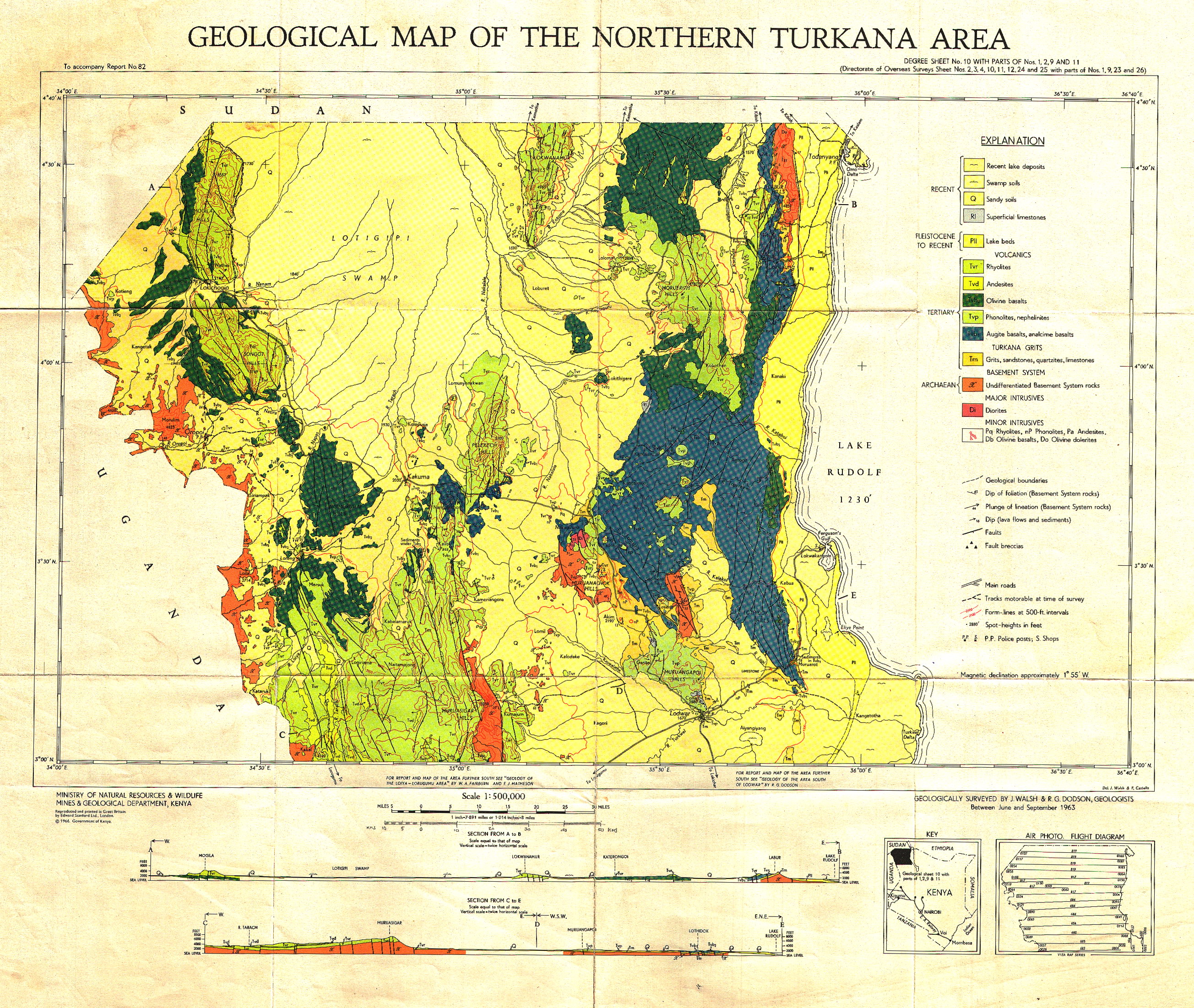
Geological map of the Voi area (65 NE)
Scale: 1:125000,
Sheet number/quarter: 65 NE
Year of publication: 1962
Filesize: 9,1 MB
Sheet number/quarter: 65 NE
Year of publication: 1962
Filesize: 9,1 MB
Map coordinates
Top left: 3° 00' S, 38° 30' E
Top right: 3° 00' S, 39° 00' E
Bottom left: 3° 30' S, 39° 00' E
Bottom right: 3° 30' S, 38° 30' E
Top left: 3° 00' S, 38° 30' E
Top right: 3° 00' S, 39° 00' E
Bottom left: 3° 30' S, 39° 00' E
Bottom right: 3° 30' S, 38° 30' E

Geological map of the Wajir area (31 NE)
Scale: 1:125000,
Sheet number/quarter: 31 NE
Year of publication: 1956
Filesize: 7,4 MB
Sheet number/quarter: 31 NE
Year of publication: 1956
Filesize: 7,4 MB
Map coordinates
Top left: 2° 00' N, 40° 30' E
Top right: 2° 00' N, 41° 00' E
Bottom left: 1° 30' N, 41° 00' E
Bottom right: 1° 30' N, 40° 30' E
Top left: 2° 00' N, 40° 30' E
Top right: 2° 00' N, 41° 00' E
Bottom left: 1° 30' N, 41° 00' E
Bottom right: 1° 30' N, 40° 30' E

Geological map of the Wajir Bor area (31 NE)
Scale: 1:125000,
Sheet number/quarter: 31 NE
Year of publication: 1956
Filesize: 6,7 MB
Sheet number/quarter: 31 NE
Year of publication: 1956
Filesize: 6,7 MB
Map coordinates
Top left: 2° 00' N, 40° 30' E
Top right: 2° 00' N, 41° 00' E
Bottom left: 1° 30' N, 41° 00' E
Bottom right: 1° 30' N, 40° 30' E
Top left: 2° 00' N, 40° 30' E
Top right: 2° 00' N, 41° 00' E
Bottom left: 1° 30' N, 41° 00' E
Bottom right: 1° 30' N, 40° 30' E
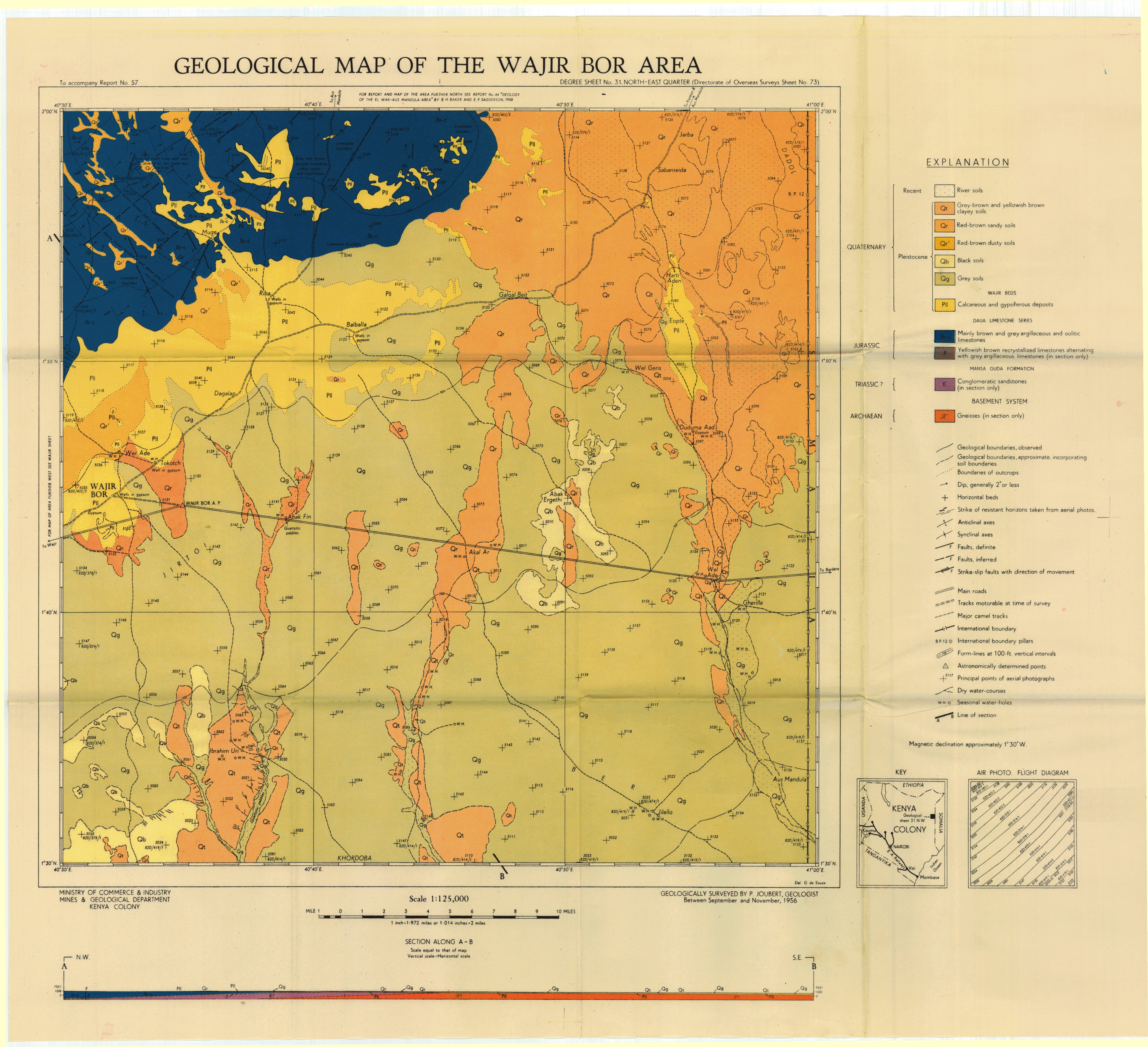
Wajir-Mandera - Composite columnar section of the rocks in the Wajir-Mandera area
Year of publication: N/A
Filesize: 0,4 MB
Filesize: 0,4 MB

Wajir-Mandera - Correlation of detailed sections in the Wajir-Mandera area
Year of publication: N/A
Filesize: 0,3 MB
Filesize: 0,3 MB


Wajir-Mandera - Reconnaissance geological map of North East Kenya
Year of publication: N/A
Filesize: 0,9 MB
Filesize: 0,9 MB
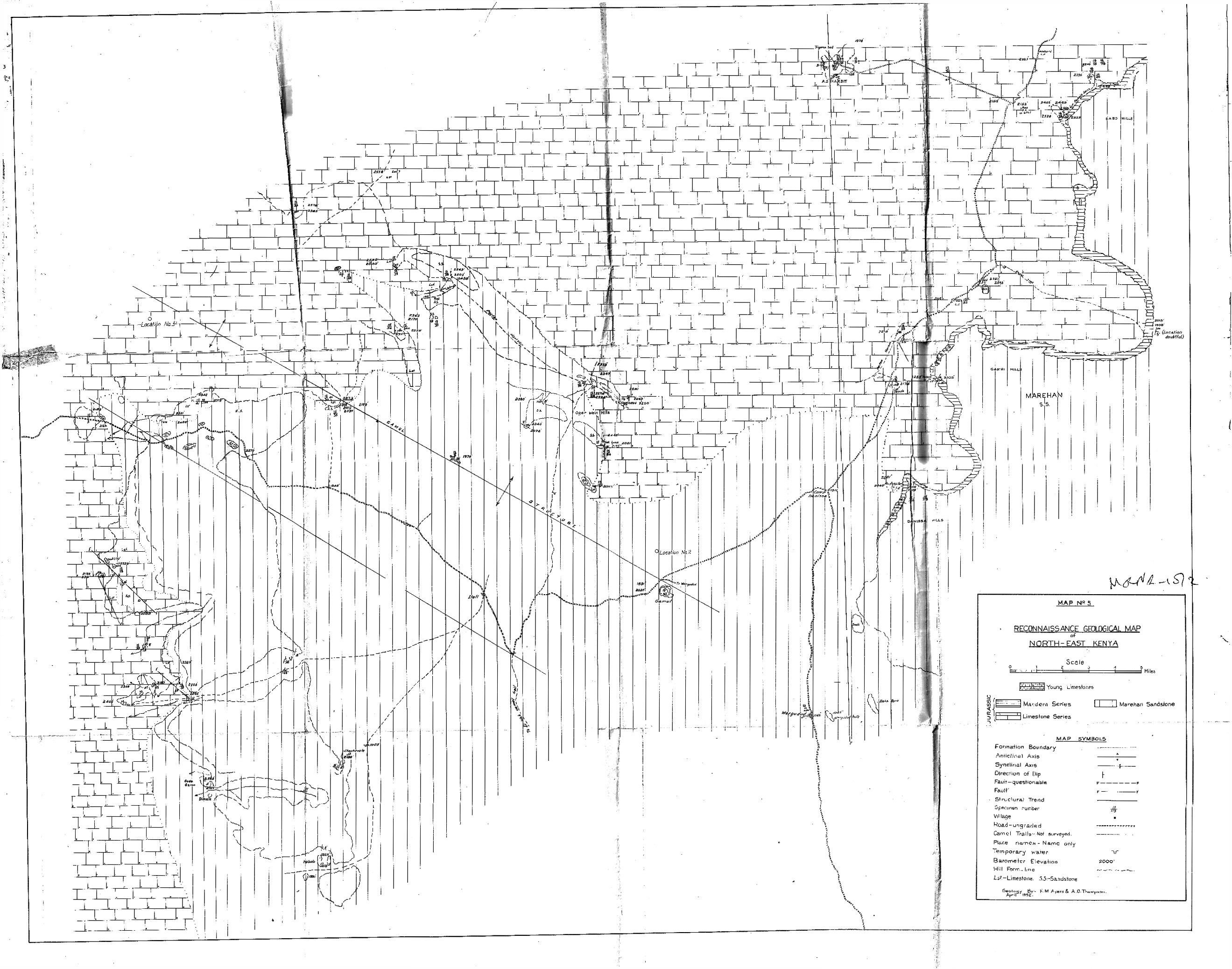
Wajir-Mandera - Stratigraphical map of the Mandera-Hafura Dedacha area
Year of publication: N/A
Filesize: 0,3 MB
Filesize: 0,3 MB

Geological map of the Wergudud area (15 SE)
Scale: 1:125000,
Sheet number/quarter: 15 SE
Year of publication: 1953
Filesize: 6,7 MB
Sheet number/quarter: 15 SE
Year of publication: 1953
Filesize: 6,7 MB
Map coordinates
Top left: 3° 30' N, 40° 30' E
Top right: 3° 30' N, 41° 00' E
Bottom left: 3° 00' N, 41° 00' E
Bottom right: 3° 00' N, 40° 30' E
Top left: 3° 30' N, 40° 30' E
Top right: 3° 30' N, 41° 00' E
Bottom left: 3° 00' N, 41° 00' E
Bottom right: 3° 00' N, 40° 30' E

Yatta South (60 SE, 60SW, NW and NE)
Scale: 1:125000,
Sheet number/quarter: 60 SE, 60SW, NW and NE
Year of publication: 1962
Filesize: 9,2 MB
Sheet number/quarter: 60 SE, 60SW, NW and NE
Year of publication: 1962
Filesize: 9,2 MB
Map coordinates
Top left: N/A
Top right: N/A
Bottom left: 3° 00' S, 39° 00' E
Bottom right: N/A
Top left: N/A
Top right: N/A
Bottom left: 3° 00' S, 39° 00' E
Bottom right: N/A
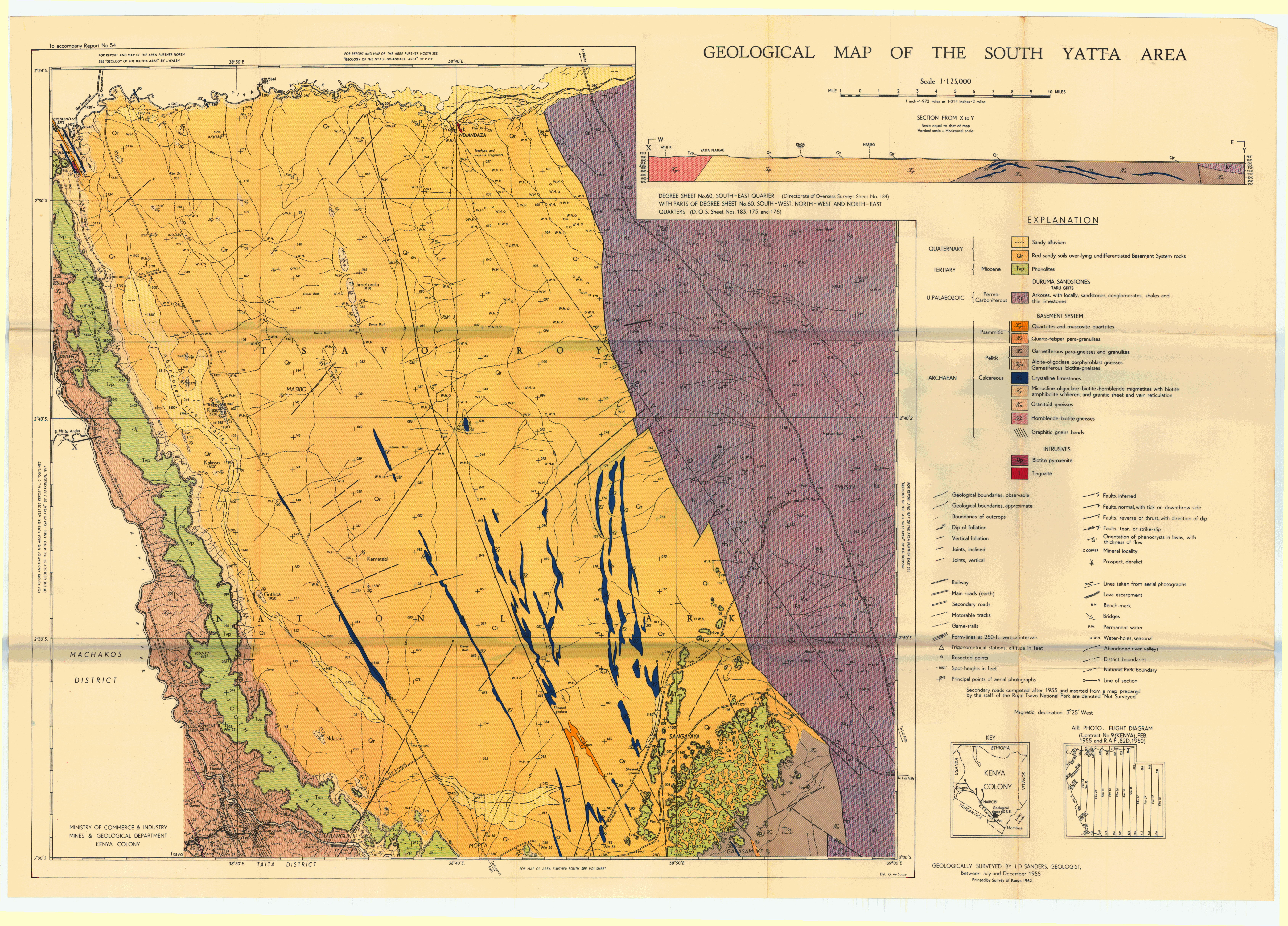


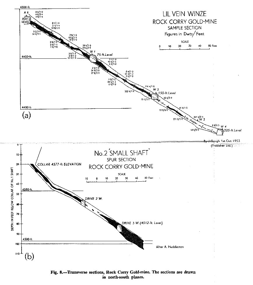